78.4 km one way
Mountain biking is only allowed from 1 May - 30 November.
Image gallery
Video
The Heaphy Track has reopened as a through route with a new bridge across the Heaphy River.
Explore on Google Street View | Watch videos
Places to stay
There are 6 huts and 9 campsites, which must be booked well in advance all year round.
Hut facilities
Huts have: bunks. mattresses, heating, toilets, basic cooking facilities
Check individual huts for cooking facilities and lighting provided. Huts do not have food, cooking utensils, showers or bedding.
A DOC ranger may be present.
Campsite facilities
Campsites have basic facilities including toilets, sinks and a water supply. Some also have picnic tables and cooking shelters. Campers cannot use hut facilities.
The track is well marked and signposted, but some sections may be steep and rough and the track could be muddy.
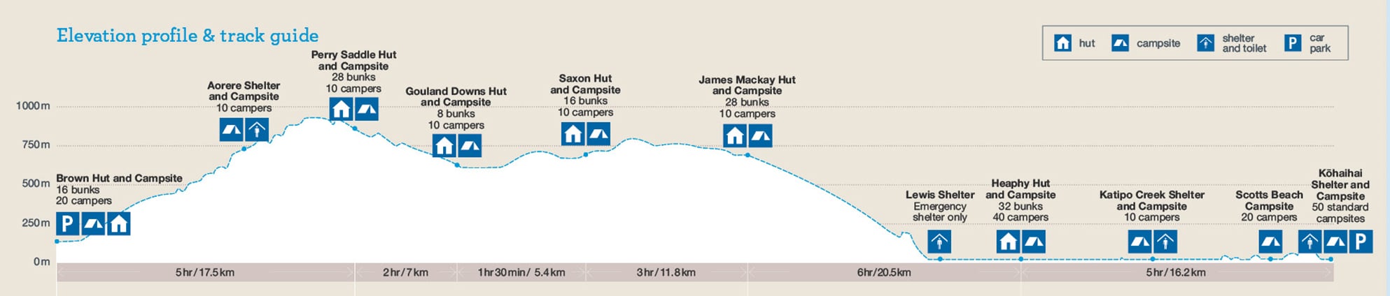
Brown Hut to Perry Saddle Hut
Time: 5 hr walking, 2 hr 30 min–3 hr 30 min mountain biking
Distance: 17.5 km
About 180 m upstream from the hut, cross the bridge over the Brown River, then a grass flat, before winding up a well-defined track and into the bush. The track climbs gradually, following a route once surveyed for a road.
After 4 hours, you'll reach Aorere Shelter. From here, the Aorere Valley is seen extending northwards and on clear days it is possible to see Mt Taranaki/Egmont. Thirty minutes before Perry Saddle Hut, a short track leads to a viewpoint at Flanagans Corner. At 915 m, this is the highest point on the track.
Perry Saddle Hut is 880 m above sea level. Near the hut in Gorge Creek is a deep but cold pool, popular for swimming.
Mountain biking: The ride starts with a consistently graded steady climb, passing Aorere Shelter and winding up to 890 m through beech forest to Perry Saddle Hut.
Take extra care between the turnoff to Shakespeare Flat and the lookout at Flanagans Corner especially when descending. There are a number of steep drops beside the track.
Campsites and huts between Brown Hut and Perry Saddle
Perry Saddle to Gouland Downs Hut
Time: 2 hr walking, 1-2 hr mountain biking
Distance: 7 km
Cross Perry Saddle and sidle above Perry Creek through tussock clearings and patches of beech. Soon the valley widens and the track climbs a small rise to where the Gouland Downs, an open tussock area, is revealed stretching out to the west.
The track meanders easily down to Cave Brook, passing the famed pole to which trampers have tied old boots over the years. Just beyond the brook is Gouland Downs Hut. Nearby, a small patch of beech grows on a limestone outcrop which has escaped erosion. This area is worth exploring. The track crosses one of several limestone arches, which are the remnants of old caves. Nearby, a small waterfall flows out of another cave passage.
Mountain biking: A mainly downhill ride to Gouland Downs on a wide, well-formed track. Initially, the track is quite steep with technical stony sections and deep streams.
Campsites and huts between Perry Saddle and Gouland Downs Hut
Look and listen out for great spotted kiwi/roroa and takahē around Gouland Downs.
Gouland Downs Hut to Saxon Hut
Time: 1 hr 30 min, 1-2 hr mountain biking
Distance: 5.4 km
Beyond Gouland Downs Hut the track is relatively level as it crosses the northern part of Gouland Downs. The tussock country and riverbeds make for good exploring but, when the mist lowers, the featureless downs can be confusing and it is easy to become disorientated.
Saxon Hut, nestled near the end of the downs, is named after John Saxon, who surveyed the track in 1886.
Campsites and huts between Gouland Downs Hut and Saxon Hut
Saxon Hut to James Mackay Hut
Time: 3 hr walking, 2-3 hr mountain biking
Distance: 11.8 km
From Saxon Hut the track drops slightly to grassy flats beside the Saxon River and then climbs gently up to a broad ridge, which joins Gouland Downs to Mackay Downs.

Flood prone area between Saxon and James Mackay huts
A section on Mackay Downs floods in extremely wet conditions. This is a 70 m piece of the track across a wetland and a bridge. It becomes impassable and quite dangerous. Walkers should wait for the water to recede.
The track now skirts the edge of Mackay Downs to James Mackay Hut, winding in and out of several small streams, just before they tumble off the downs and fall to the Heaphy River on the left. The vegetation is alternately tussock field and shrub-fringed patches of beech forest. Small creeks dissect the landscape and the pink granite sparkles and crunches beneath your feet.
James Mackay Hut is situated just above the track on an open terrace. The Tasman Sea and Heaphy River mouth can be seen from here, 15 km to the west and 750 m below. It is named after the explorer who first pressed for a bridle track to be established between Collingwood and the West Coast.
Campsites and huts between Saxon Hut and James Mackay
James Mackay Hut to Heaphy Hut via Lewis Shelter
Time: 6 hr walking, 2.5 hr - 4.5 hr mountain biking
Distance: 20.5 km
Beyond James Mackay Hut, a gradual descent to the Heaphy River begins. The track is through beech forest at first but soon the richer and taller forest typical of the West Coast becomes dominant. Occasional tantalising glimpses of the Heaphy River below are seen through the forest. The sounds of rushing water grow louder and suddenly Lewis Shelter appears at the junction of the Heaphy River with the smaller Lewis River, along with sandflies and the first nikau palms.
Lewis Shelter is an emergency shelter - no overnight stays. Charles Lewis was a Collingwood surveyor who, in the 1880s, was first to investigate Mackay’s proposed bridle route.
From Lewis Shelter, continue to the 101m long Lewis River swing bridge and enjoy the views to the confluence of the Heaphy river. After a short distance you cross the Heaphy River swing bridge, as you reach the bridge notice the two large rata trees, possibly the oldest and largest in New Zealand.
The track continues along the left bank to the river mouth through a forest of kahikatea, rimu and rata. Glossy-leaved shrubs perch precariously in the tall trees, flourishing in the abundant light and extracting nutrients from humus (accumulated plant debris) in their hosts’ branches.
In dry spells, the sluggish river meanders along peacefully, but in times of heavy rain especially when it’s high tide, sections of the track and bridges get flooded. An area of limestone and karst locally known as Cave Stream about 15 min before Heaphy Hut, floods after periods of heavy rain.
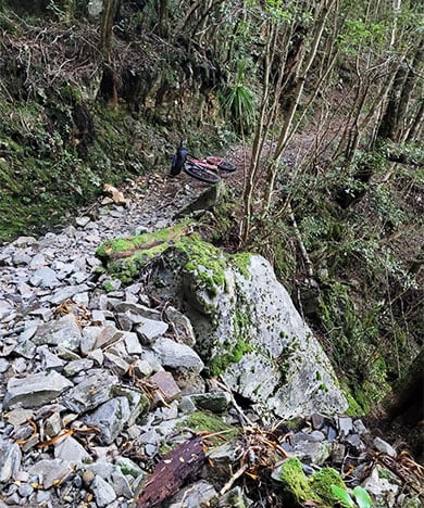
Mountain biking: This section is technical but an invigorating descent to Lewis Shelter. The track is rocky, rutted and soft in places. Get off your bike and walk these soft, muddy sections to avoid damage to the track or yourself.
Take extra care through this section, particularly in the approach to Lewis Shelter. There are a number of steep drops beside the track, especially in the section of track 2.5-1km before Lewis Shelter.
From Lewis Shelter there are a number of suspension and swing bridges on this section. The suspension bridges are ride-able or alternatively use the approved MTB swing bridge crossing method. This method involves flipping your bike on its back with the rear wheel angled away from you at 45 degrees. With the stem in one hand move yourself by gripping the top wire with your other hand.
Stay in Heaphy Hut if the track is flooded. It's not safe to proceed when the track is flooded – you should wait in either Lewis Shelter or Heaphy Hut.
Towards the river mouth, nikau palms become more common, the sea’s incessant roaring grows louder and, in some conditions, small waves can be seen running upriver. Heaphy Hut is situated far enough back from the sea to be spared the worst of the winds.
The river mouth is at the junction of two pounamu (greenstone) trails and archaeological work has uncovered evidence of occupation by Māori that extends back 500 years. In 1905, an extensive European settlement was surveyed in the lower valley, but it was never built.
Warning: Do not swim at the Heaphy River mouth as strong currents may wash you out to sea.
Campsites and huts between James Mackay Hut and Heaphy Hut
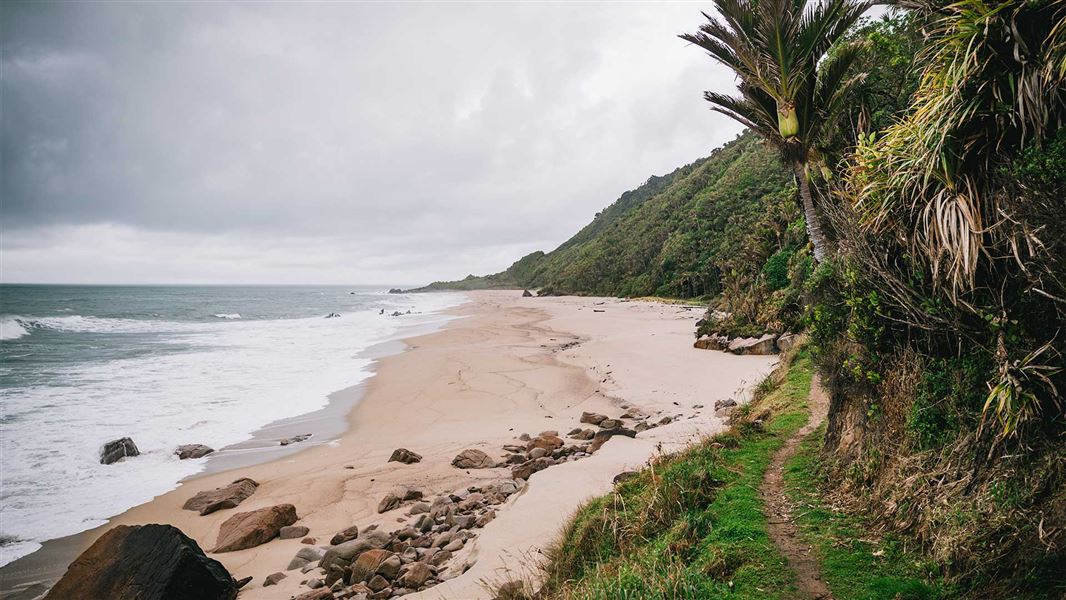
Heaphy Hut to Kohaihai River Mouth
Time: 5 hr walking, 3-4 hr mountain biking
Distance: 16.2 km
Warning: Sections of the coastal track between Heaphy Hut and Kohaihai may be affected by large wave surges during high tides and rough seas which can cause the track to be temporarily impassable. Check tide timetables
The Heaphy River mouth is an exciting place. The river surges out through a narrow gap into the sea - in-coming waves halt the flow and the churning of salt and fresh waters is spectacular.
The track south to Kohaihai is through forest although beach walking is possible in some places. Some of the small streams are not bridged and can be dangerous after heavy rain. The forest has rata and karaka trees, many vines and groves of nikau palms. Be careful of the stinging nettle that grows in places.
Just beyond Katipo Creek is Crayfish (Koura) Point. Crayfish Point no longer requires visitors to traverse the beach and plan around high tide. There is a high level track above the beach well away from the sea. The only risk that still faces people here is to take care crossing Crayfish Stream particularly after or during rainfall as it can flood quickly (and drops quickly).
Soon Scotts Beach is reached – the clearing here is a good spot to rest before climbing over Kohaihai Saddle and down through wind-blasted shrubs to a bridge across the Kohaihai River. The track follows the riverbank for 400 m to Kohaihai carpark where there is a shelter and phone.
The section of track around the Kohaihai River mouth may experience flooding issues when the river mouth becomes blocked. An alternative track has been put in place to allow visitors to bypass this area when this occurs.
Warning: It's dangerous to wade or swim at the mouth of the Kohaihai River due to extreme tidal currents and rips.
Campsites and huts between Heaphy Hut and Kohaihai Campsite
Ōparara Arch
On the road from Kohaihai to Karamea you'll pass the entrance to Ōparara Arch – a 35 million year-old limestone arch. You can reach the arch via a 30 min walk through beech and podocarp forests and limestone outcrops. It's a great side trip.
Fees are charged per person, per night to stay in huts and campsites on the Heaphy Track. There are no fees to complete a day walk on the track or for entry into the Kahurangi National Park.
Hut fees
Prices are per person, per night. NZ rates are for New Zealand visitors and INT rates are for international visitors.
|
Date range |
Adult NZ |
Adult INT |
Child NZ |
Child INT |
Infant NZ |
|---|---|---|---|---|---|
|
1 October – 30 April |
$44 |
$66 |
$22 |
$33 |
Free |
|
1 May – 30 June |
$38 |
$38 |
$19 |
$19 |
Free |
|
1 July – 31 August |
$30 |
$30 |
$15 |
$15 |
Free |
|
1 – 30 September |
$38 |
$38 |
$19 |
$19 |
Free |
Proof of eligibility is required for the New Zealand rate.
Campsite fees
Prices are per person, per night. NZ rates are for New Zealand visitors and INT rates are for international visitors.
|
Date range |
Adult NZ |
Adult INT |
Child NZ |
Child INT |
Infant NZ |
|---|---|---|---|---|---|
|
1 October – 30 April |
$19 |
$28 |
$9 |
$14 |
Free |
|
1 May – 30 September |
$19 |
$19 |
$9 |
$9 |
Free |
Proof of eligibility is required for the New Zealand rate.
Bookings
All huts and campsites on the Heaphy Track must be booked in advance all year round.
If you don’t have a valid booking for your stay, you may be charged a penalty, or turned away if the hut/campsite is full.
The Heaphy Track is not a circuit track.
You can start the track either from:
- Brown Hut in Golden Bay – 156 km from Nelson – at the end of Aorere Valley Rd, or
- Kohaihai on the West Coast – 110 km from Westport – at the end of Kohaihai Rd.
Air access
Air services make it possible to walk the track one way and return by air to near your starting point.
Air New Zealand flies into Nelson, the closest regional airport to the Brown Hut, and Sounds Air flies into Westport, the closest regional airport to Kohaihai.
A number of local operators provide air transport into Takaka in Golden Bay and Karamea on the West Coast.
Road access
Brown Hut is 156 km and a 2 hr 25 min drive from Nelson. To reach this eastern end of the track:
- take SH 60 from Nelson to Collingwood (128 km)
- at Collingwood take the road up the Aorere Valley to Brown Hut (28 km).
Kohaihai is 110 km and a 1 hr 45 min drive from Westport. To reach this western track end:
- take SH 67 from Westport to Karamea (95 km)
- at Karamea head north to the car park and campsite at the Kohaihai River (15 km).
Track transport
Bus and taxi services are available to reach either end of the track from nearby towns. Regular bus services link Nelson and Westport. Vehicle relocation services are also available.
There is mobile phone coverage at both ends of the Heaphy Track. The landlines at Brown hut and Kohaihai campsite have both been removed.
Some transport businesses may not operate in winter
Transport, activity, equipment and accommodation businesses operate in the summer. Some businesses do not operate in winter. Check with the operator.
Have a safe and enjoyable trip by making sure you have the right equipment and clothing.
Stay safe in the outdoors and follow the five essential steps of the Land Safety Code
Weather
Weather on the Heaphy Track changes quickly and annual rainfall averages over 4,000 mm. It rains heavily with little warning and even small streams are dangerous in a flood.
Check the forecast and expect weather changes. Kahurangi National park weather forecast – NIWA website.
Be prepared for rain, snow and wind, especially on the exposed sections of the track.
Bad weather can damage the track during winter. These areas will be marked by signs and warning tape. You should check with the Nelson DOC Visitor Centre before your walk.
Be aware that landslides and rock falls can occur on the Heaphy Track, particularly during and after rain. These can occur without warning. Sections of the track can also subside (collapse).
Average temperatures
Table showing average temperatures on Heaphy Track.
Flooding and tides
There are sometimes large floods in the Heaphy valley, between Lewis Shelter and Heaphy Hut. It's not safe to proceed when the track is flooded – you should wait in either Lewis Shelter or Heaphy Hut.
Check tide charts
Large waves can wash over parts of the coastal track when the tide is high and the sea is rough. This can mean the track is not safe to walk. When planning your trip, check tide charts and allow extra time in case you are delayed.
Tsunami risk
The New Zealand coastline is at risk from tsunamis, including Heaphy Hut and the coastal sections of the Heaphy Track. If you feel a long or strong earthquake, see a sudden rise/fall in sea level, or hear loud/unusual noises from the sea, go to higher ground immediately.
Giardia
There is a small risk of giardia in water – treat your water before you use it.
Mobile phone coverage
Generally, mobile phone coverage is poor and unreliable. Coverage is usually available at Aorere Shelter, on the beach near the Heaphy River mouth and along the coast track between the Heaphy Hut and Kohaihai Scotts Beach, coverage is usually available, although this depends on which telephone company you use.
Rules
- Bikers must give way to walkers.
- Night riding is not permitted.
- Electric bikes are not allowed on the track.
- You're not permitted to take a mountain bike into any hut or shelter, or onto hut porches.
You're responsible for:
- obeying the mountain bikers code. The track is shared with hikers and other bikers – show respect for other users.
- following signs and other markers that clearly identify where mountain bikes can be ridden and where they are not allowed
- removing your bike from the national park should it break down.
- obeying the closure of the track to mountain bike use. This will usually be after storms, heavy rain, snow or high-tide events, which may damage the track, particularly on the West Coast side.
When you can mountain bike
 Example of drops by track and terrain
Image: Nick Sutcliffe | DOC
You can mountain bike the Heaphy Track in the winter season from 1 May to 30 November. Walkers will also be on the track during this time.
Where you can bike
You can ride mountain bikes on the Heaphy Track:
- in both directions
- in a group, provided there are no more than 6 riders in the group
- during the day only from half an hour before sunrise to half an hour after sunset. This is to protect two threatened nocturnal species found on parts of the track: the Powelliphanta snail and roa (great spotted kiwi).
You are not permitted to take a mountain bike:
- in or out of the national park by helicopter
- into any hut or shelter, or onto hut verandas or porches
- off the formed and designated route.
Track advice
The Heaphy Track is a tough ride – it is not a cycle trail.
To ride safely, you need to be fit, experienced, have good equipment and ideally have tested it out before arriving on the track.
The track is suited to riders that can do advanced Grade 4 mountain biking tracks. Fit, experienced riders should plan for two full days, staying overnight in a hut or designated campsite. Less experienced riders should anticipate a 3 day, 2-night trip.
Mountain bike track grade description
You can expect:
- a well-formed 78.4 km track maintained to DOC Great Walk standard
- bike stands at Perry Saddle, Gouland, Saxon, James Mackay and Heaphy huts
- numerous bridges, like swing and suspension, bridges
- some rough track on the West Coast side. This area is more vulnerable to damage from rutting and erosion
- changeable weather, including extremely cold temperatures, rain, wind and possibly snow. There are steep slopes, many bridges, avoidable obstacles and sections of track prone to deep flooding.
- some steep drops beside the track
Watch out for takahē and the giant land snail:
- takahē have been released into Gouland Downs and are sometimes seen on or near the track. Ride with caution in this area
- the giant land snail, Powelliphanta, maybe on the track during the day, particularly after rain Ride carefully and slowly through these areas, which are marked by signs – these snails are rare and unique to this part of New Zealand.
Beware:
- of tight corners and slippery rock between James Mackay Hut and Lewis Shelter
- of steep drops beside the track, especially between the turnoff to Shakespeare Flat and the lookout at Flanagans Corner, and on the descent to Lewis Shelter
- kea at James Mackay Hut have become attracted to bike seats and hydraulic brake lines When staying overnight in a hut, remove your seat from your bike, keep it with your other personal items, and cover your brake lines
- flooding in the Saxon/James Mackay section and the lower Heaphy Valley can reach 1.5 metres deep over the track. Be prepared to wait until it’s safe to continue, or return to James Mackay Hut
- a section between Heaphy Hut and Kohaihai Shelter is on a sandy beach. High tide or rough seas may delay your ride.
Fitness and what to take
You need to have a good standard of fitness, a reliable bike, and to carry all your food, clothes, overnight and personal gear, and bike tools and equipment.
This is a backcountry environment where you need to be self-reliant. At least one member of your party should know how to fix a bike.
If you plan to stay overnight, book your huts or campsites. Take your hut or campsite ticket with you if that is what you're using.
Heaphy Track has unique wildlife including spotted kiwi/roroa and takahē.
Nature and conservation on the Heaphy Track.
The human history of Heaphy Track dates back hundreds of years.
Stay safe in the outdoors
- Choose the right trip for you. Learn about the route and make sure you have the skills for it.
- Understand the weather. Check weather forecasts.
- Pack warm clothes and extra food. Check gear lists.
- Share your plans and take ways to get help. Leave your intentions with a trusted contact and take a distress beacon.
- Take care of yourself and each other.
Nelson/Tasman/Marlborough information
| Phone: | +64 3 546 9339 |
| Email: | nelsonvc@doc.govt.nz |
| About: | Whakatū/Nelson visitor services provide information for this area |
Paparoa National Park Visitor Centre
| Phone: | +64 3 731 1895 |
| Email: | paparoavc@doc.govt.nz |
| Address: | 4294 Coast Road Punakaiki RD 1 Runanga 7873 |
| Hours: | Visitor centre hours and services |