It reaches beyond wind-whipped Lakes Wanaka and Hāwea, through golden tussock-covered hills, to wind among steep mountains cloaked in lush rainforest and cross tumbling rivers. It then skirts undulating forests that seemingly float in tea-stained swamps, to finally reach the foaming surf of the Tasman Sea.
Explore walks along the way and stop at one of the four campsites.
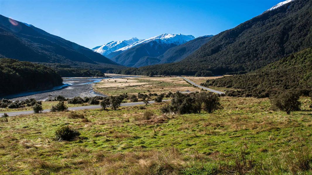
Walks
- Roaring Billy Falls Walk
- Thunder Creek Falls Walk
- Fantail Falls Walk
- Bridle Track
- Haast Pass Lookout Track
- Cameron Lookout Walk
- Blue Pools Track
- Makarora Bush Walk
- Kidds Bush Nature Walk
- Sawyer Burn Track
Campsites
Other activities
Introduced brown and rainbow trout are found in the Makarora, Young and Wilkin Rivers and provide excellent fishing – with the required licence.
Most of the rock along the Haast Pass/Tioripatea road is schist, formed under intense heat and pressure. An important geological feature, the Alpine Fault, which runs the length of the Southern Alps/Kā Tiritiri o te Moana, crosses the road just east of Haast, though unseen by travellers.
During the Ice Ages huge glaciers scoured and shaped the landscape, including the pass, to leave U-shaped and hanging valleys in their wake, as well as ice-smoothed granite outcrops such as Mosquito Hill near Haast. Silt and gravel spread by rivers in the millennia since now covers the valley floors, creating the classic wide terrace flats of both the Haast and Makarora Valleys.
Rainfall varies considerably in the area: 3800 mm a year at Haast to more than 8300 mm on the lower western slopes, to drop to 4500 mm at Haast Pass/Tioripatea itself, and only 2000 mm at the head of Lake Wanaka. Combined with altitude, this has a significant effect on vegetation.
West of the pass, kāmahi is the most common tree, with swamp forests of rimu, kahikatea and silver pine thriving on the boggy lower slopes and terraces. From Thunder Creek to Makarora, silver beech dominates, with remnants of matai, miro, kahikatea and rimu in places such as Makarora Bush. At the drier, lower end of the Makarora Valley a few pockets of mountain beech survive amongst the scrub and pasture.

Female paradise shelduck
Insect eating birds such as the fantail/pïwakawaka, tomtit/miromiro, and rifleman/titipounamu, are common through out the forest, and mohua/yellowhead and kakariki/yellow-crowned parakeet, are locally common. The striking paradise shelduck/pūtakitaki is a familiar sight on the open river flats.
.")
Haast Highway construction (1930s)
Haast Pass/Tioripatea has always been an important route between Central Otago and the West Coast. Māori from the West Coast, Foveaux Strait and Coastal Otago crossed the pass to trade pounamu (greenstone) and food and named it Tiori-patea, meaning ‘the way ahead is clear.’ They had camps around Lakes Wanaka and Hawea and in the Makarora Valley, which they called Kaika Paekai, ‘The place of abundant food.’ Some journeys weren’t as peaceful; Te Puoho, a northern chief brought his warriors through the pass in 1836 to raid the southern Kāi Tahu and Kati Mamoe tribes. Initially, Te Puoho’s raid was successful, winning an early skirmish near Wanaka, but further south all of his party were either killed or taken prisoner and used as slaves
Charles Cameron, an explorer and gold prospector, is generally acknowledged as the first European to cross the pass, in 1863. A short time later, Julius von Haast, Canterbury’s Provincial Geologist, led a party of four over the pass and on to the West Coast where they ‘...stood in the surf giving three hearty cheers.’
By 1876 there was a narrow pack track over Haast Pass/Tioripatea. In the following decade a government grant paid for the first construction work to be carried out on what some hoped would be a railway as well as a road, as it was cleared to as much as 10 m wide. Prospectors and early settlers at Haast were the first to use the route. Next came our earliest tourists – on horse back – then livestock being moved to and from Haast on the coast.
Most of the work on the Haast Pass/Tioripatea road was carried out during the 1930s depression when up to 400 men were employed. They lived in temporary camps and spent long hard days with pick, shovel and horse-drawn carts. The onset of World War II stopped this and the road to Haast was finally completed in 1960. The last stretch, north of Haast, linking the rest of Westland with Otago wasn’t finished until 1965.
At 563 m above sea level, Haast Pass/Tioripatea is virtually an all-weather road and the lowest of the three road passes that link Westland with the east coast.
Wānaka Tititea/Mount Aspiring National Park
Visitor Centre
| Phone: | +64 27 269 6871 |
| Email: | wanakavc@doc.govt.nz |
| Hours: | Visitor centre hours and services |