Fitness required: High
Gradient: Steep
16 km return via same track
- The track is closed for lambing from the 1 October - 10 November each year. It reopens on the 11 November (in time to hike the track for sunrise).
- Snow and ice present in winter.
Image gallery
Video
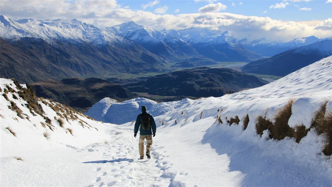
With beautiful Wānaka as the backdrop, you’ll climb from lake level through farmland then up into the tussock tops to the 1578 m summit.
The sounds of grasshoppers and skylarks surround you as you climb 1,500 m on a well-formed track with the most spectacular views of Lake Wānaka, its islands, bays, and the mighty snow-capped mountains of the Southern Alps/Kā Tiritiri o te Moana, including Mount Aspiring/Tititea.
This track crosses private land. Respect the landowner's livestock and property. Stay on the marked track, leave gates as you find them and use stiles where provide.
During the lambing closure, a good alternative track of similar length and difficulty that offers an equally spectacular view is the Isthmus Peak Track.
Roys Peak Track virtual guide
Watch a NZ Mountain Safety Council video.
From Wanaka, drive west along the Wanaka - Mount Aspiring Road for about 6 km until you reach the large car park on your left, from where you can start the track.
At times of high use, during summer, consider walking or cycling to the car park (via the Waterfall Creek Track that links to the Roys Peak Track) as there is limited parking available.
Transport providers are available, contact the Mt Aspiring National Park Wanaka Visitor Centre for options.
What to expect
- Change in elevation: 1,228 m

Hazards
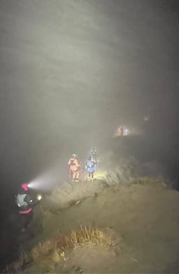 Head torches, spare batteries and very warm clothes are essential if attempting to hike in the dark.
Image: Kinisi Running | ©
The weather changes rapidly in this region. Hypothermia is a real risk even in summer.
Winter
Snow and ice maybe present, crampons, good hiking boots and walking poles maybe required. In winter the top section of the track has challenging avalanche terrain above the 1000 m mark. Find out more about this on the New Zealand Avalanche Advisory website or check with the Tititea/Mt Aspiring National Park Visitor Centre.
Weather forecast
Roys Peak weather forecast – NIWA website
Prevent wildfires: If using a gas camp cooker in the Stack Conservation area choose a site that is clear of combustible materials. Campfires are not permitted.
Amenities
- Toilets at beginning and end of the track.
What to take
How to pack for a day walk
All drone use must be authorised by DOC
You must have a permit to fly a drone on public conservation land.
Visit our Drone use on conservation land page for more information.
Nature's in trouble
Thousands of New Zealand’s native species are heading towards extinction. Once they’re gone, they’re gone for good. Nature needs your help.
Stay safe in the outdoors
- Choose the right trip for you. Learn about the route and make sure you have the skills for it.
- Understand the weather. Check weather forecasts.
- Pack warm clothes and extra food. Check gear lists.
- Share your plans and take ways to get help. Leave your intentions with a trusted contact and take a distress beacon.
- Take care of yourself and each other.
Wānaka Tititea/Mount Aspiring National Park
Visitor Centre
| Phone: | +64 27 269 6871 |
| Email: | wanakavc@doc.govt.nz |
| Hours: | Visitor centre hours and services |