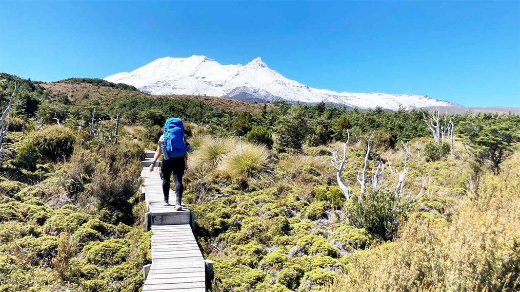
Image gallery
Walking options
- You can walk the Round the Mountain Track in either direction; here we describe it going clockwise. Consider recent or forecast rainfall in choosing your route, given the unbridged river crossings.
- You can also do a part of the track over 2 or 3 days, for example between Whakapapa Village and Ohakune Mountain Road on either the western or eastern side of Ruapehu. There are shuttle services available.
Places to stay
There are six huts available on the Round the Mountain Track: Waihohonu, Rangipo, Mangaehuehu, Blyth, Mangaturuturu and Whakapapaiti. There is also a campsite at Waihohonu.
Waihohonu Hut and Campsite require advance booking in the Great Walks season. Book all huts before you start hiking.
Hut rangers are not present, although DOC rangers do periodically check facilities. There is a resident Hut Warden at Waihohonu Hut during the Great Walks season.
Camping outside the designated campsites is allowed in the National Park, except:
- Within 500 m of the Tongariro Northern Circuit Track, which includes the track between Whakapapa and Waihohonu Hut
- Within 200 m of the Round the Mountain Track
Whakapapa Village to Waihohonu Hut
Time: 5 hr 30 min
Distance: 14.3 km
The track begins along Ngauruhoe Place, 100 m below Whakapapa Visitor Centre. There are two options. The Lower Taranaki Falls Track crosses tussock and shrubland before following the Wairere Stream through mountain beech forest to the base of Taranaki Falls. On leaving the falls, the track climbs a set of steps and brings you to the junction with the Upper Taranaki Falls Track (1 hr, 25 min to this point). Alternatively, the Upper Taranaki Falls track takes you over tussock and shrubland to the same point in 1 hr.
After leaving the Taranaki Falls Track, it is a further 2 hr to Tama Saddle and Tama Lakes junction. From here a side trip can be made to the Tama Lakes. Tama Saddle is exposed and conditions can be windy in bad weather.
From Tama Saddle the track gradually descends for 2.5 hr down the Waihohonu Stream to Waihohonu Hut. A side trip can be made from the Round the Mountain track to the historic Waihohonu Hut, about 10 minutes before you reach the new Waihohonu Hut.
Side trip: Tama Lakes
Time: 20 min return to Lower Tama from the junction, 1.5 hr return to Upper Tama from the junction.
Tama Lakes, two infilled explosion craters, are named after Tamatea, the high chief of the Takitimu Canoe, who explored the area six centuries ago.
The lower lake (at 1200 m), is 10 min from the junction. Volcanic debris is slowly washing in and filling the crater. The upper lake (at 1314 m) is a further 40 minutes up a steep ridge. This beautiful lake is reputed to be very deep.
Side trip: Historic Waihohonu Hut
Time: 20 min return from the new Waihohonu Hut, 10 min return from the Round the Mountain Track, 3 hr (6.3 km) return from Desert Road (State Highway 1)
Built in 1903/04, this was the first hut built in Tongariro National Park. It's the oldest example of a typical early two-room mountain hut in New Zealand. Historic Waihohonu Hut
Waihohonu Hut to Rangipo Hut
Time: 5 hr
Distance: 12.5 km
The track from Waihohonu Hut to Rangipo Hut is in one of the most unique areas in the park. It is the only true desert landscape in the North Island, and as such, features vast plains of wind sculptured sands and volcanic rock. The Rangipo Desert is dryer than most areas in Tongariro National Park as it is sited in the rain shadow to the east of Mt Ruapehu.
The track passes Ohinepango Springs then traverses the eastern side of Ruapehu, past the Tukino Mountain Road, the Whangaehu River, eventually arriving at Rangipo Hut. The hut is perched on the southern edge of the desert with views east to the Kaimanawa mountains.
Side trip: Ohinepango Springs
Time: 1 hr return from new Waihohonu Hut, 5 min return from Round the Mountain Track
Crystal clear cold water bubbles up from beneath the old lava flow and discharges at an enormous rate into the Ohinepango Stream.
The springs are signposted on the Round the Mountain Track heading towards Rangipo Hut.
Rangipo Hut to Mangaehuehu Hut
Time: 5 hr 30 min
Distance: 8.5 km
The trip from Rangipo to Mangaehuehu is an undulating traverse. It leaves the desertlands of Rangipo, re-entering the mountain beech forest on the southern flanks of Mt Ruapehu. A feature of this section of track is crossing the awesome Waihianoa Gorge which cuts a path down the mountain into Karioi Forest.
Mangaehuehu Hut to Ohakune Mountain Road
Time: 3 hr
Distance: 8.9 km
The gradual downhill traverse from Mangaehuehu weaves through open alpine tussock country and mountain beech stands.
After 1 hr 30 min, a track junction gives walkers the option of a side trip to Blyth Hut (1 hr return) or continuing out to the Ohakune Mountain Road. About 20 min past the track junction are the Waitonga Falls (39 m), reputedly the highest falls in Tongariro National Park. The track out to the road passes Rotokawa, an alpine tarn featuring several alpine wetland species and spectacular views of Ruapehu on a clear day.
A second junction indicates the Old Blyth Track (1 hr 30 min to the 7 km point on the Ohakune Mountain Road) on the left, or 15 minutes to continue on to Waitonga Falls carpark (the 11 km point on the Ohakune Mountain Road). Walk 3 km up the road to link up with the next section of Round the Mountain Track.
Side trip: Blyth Hut
Time: 1 hr return from the junction east of Waitonga Falls
Access Blyth Hut from the junction just east of Waitonga Falls on the Round the Mountain Track.
Following a gentle climb through mountain beech forest, you emerge out into the open, from where the hut is a short climb above the headwaters of the Mangateitei Stream. The hut site features expansive views of the mountain and the countryside to the south.
Ohakune Mountain Road to Mangaturuturu Hut
Time: 1 hr 30 min
Distance: 3 km
The track begins 3 km further up the road from the exit of Mangaehuehu Hut and Waitonga Falls track (15 km from Ohakune township).
Follow the track down into the Makotuku Valley, then cross a lava ridge covered in alpine herbs.
The track then descends into the expansive Mangaturuturu Valley via the Cascades, where a mountain stream tumbles over a spectacular rockfall. The rocks are coated with a creamy-coloured silica deposit left behind by the fast flowing stream. Caution: the rocks can be slippery during wet or icy conditions.
Mangaturuturu Hut, situated on the valley floor, is maintained jointly by DOC and the Wanganui Tramping Club.
Mangaturuturu Hut to Whakapapaiti Hut
Time: 5 hr 30 min
Distance: 10.3 km
Shortly after leaving the hut, the track crosses the Mangaturuturu River. Caution: It may not be possible to cross safely when the river is high during or following rain. The river bed was scoured out in 1975 by a lahar (volcanic mud flow), thus the sides of the river are devoid of established vegetation.
A climb out of the valley brings you to Lake Surprise, a shallow alpine tarn. The staircase that climbs up from Lake Surprise onto the ridge above, was constructed to protect the fragile alpine environment.
The traverse to Whakapapaiti features two magnificent river valleys, the Manganui-o-te-Ao and the Makatote. This part of the track features views of Hauhungatahi, a conical peak to the northwest of Ruapehu, as well as spectacular waterfalls tumbling off lava bluffs in the Whakapapaiti Valley.
At the junction just before Whakapapaiti Hut, you have the option of continuing on to Scoria Flat on the Bruce Road (1 hr 30 min), or turning off to Whakapapaiti Hut (15 min) and on to Whakapapa Village (2 hr 30 min).
Whakapapaiti Hut to Whakapapa Village
Time: 2 hr 30 min
Distance: 8.7 km
From the Whakapapaiti Hut the track continues down the valley. 15 min below the hut it crosses Whakapapaiti River. When the river flow is low, you can boulder hop across - but after rain it is not possible to cross safely. You can avoid the main river crossing, and exit along the top return route to the Bruce Road at Scoria Flat, 5 km above Whakapapa Village.
About 45 minutes below the hut the Mangahuia Track branches off to the left (to Mangahuia Campsite and SH47). The track to the village continues straight on then veers east. Interesting features of this area are the groves of kaikawaka and cabbage trees amongst the beech forest.
From here the track undulates for a number of easy climbs and descents before joining the well formed Silica Rapids Track, for the last 45 min to Whakapapa Village.
Hut details and tickets
Waihohonu requires advance reservation in the peak season, as it is a Great Walk hut/campsite. Backcountry tickets or passes are required in the off peak season.
The other five huts/campsites are on a first come basis year round, and backcountry tickets or passes are required.
You can access the Round the Mountain Track from several locations.
From Whakapapa Village
There is a parking area in Whakapapa village opposite the Visitor Centre.
From Whakapapa Village to Waihohonu Hut (clockwise direction)
The walk to Waihohonu Hut is 5 hr 30 min. The track entrance is from Ngauruhoe Place, 100 m below the Visitor Centre.
From Whakapapa Village To Whakapapaiti Hut (anti-clockwise direction)
The track entrance is just above Whakapapa Holiday Park, and is also the track entrance for the Silica Rapids / Whakapapaiti Valley Track. The walk to Whakapapaiti Hut is 2 hr 30 min.
Alternatively, there is an entrance 5 km further up Bruce Road from Whakapapa Village. From here the walk is 1 hr 30 min to the Whakapapaiti Hut, or 7 hr to the Mangaturuturu Hut.
From Desert Road (SH1)
There is a parking area just off the Desert Road, 31 km from Tūrangi or 21 km from the Rangipo Junction. It is approximately 1 hr 30 min to Waihohonu Hut, then a further 5 hr to Rangipo Hut.
Ohakune Mountain Road
The Ohakune Mountain Road has two access points for the Round the Mountain Track; Waitonga Falls carpark (at 12 km - anti-clockwise direction) and Wanganui Corner (at 15 km - clockwise direction). Both have parking areas, and shuttle services are available from Ohakune.
Tongariro Northern Circuit
The Round the Mountain Track connects with the Tongariro Northern Circuit track at two points; Whakapapa Village and the Waihohonu Track junction.
Tukino Road
This is not a regular access point for the track; it is the access road to Tukino ski field. It is a rough gravel road and a four wheel drive is required. In winter it is often impassable due to snow.
From where the Round the Mountain Track crosses the road, it is an 2 hr walk to either Rangipo Hut or Waihohonu Hut.
Vehicle security
When leaving your vehicle at track entrance parking areas, take valuable items with you and lock your vehicle. Alternatively, there are parking areas at Whakapapa Village and local towns, and transport is easy to arrange to and from the tracks.
Transport options
- Shuttle bus transport to and from the various trail heads is available with several local operators. You can arrange services from local towns Whakapapa Village, National Park, Ohakune and Tūrangi.
- There are no scheduled services - all transport arrangements must be made direct with transport operators before departure.
What to expect
Your safety is your responsibility. Stay safe in the outdoors and follow the five essential steps of the Land Safety Code.
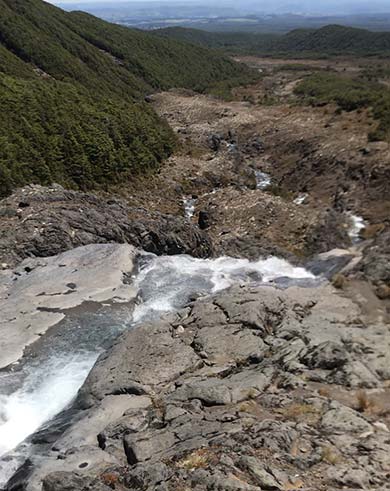
The Cascades are slippery when wet or icy
Image: DOC
On the Round the Mountain Track, be aware that:
- Most of the track is on rugged and exposed alpine terrain, there are just a few sections of forest around the western and southern sides. The lowest altitude of the track is about 1100 m, and the highest (at Rangipo Hut) is close to 1600 m.
- There are some unbridged streams and river crossings, including the two larger rivers - the Whakapapaiti and Mangaturuturu rivers on the western side of Ruapehu. You will need to know how to cross rivers safely.
- Major hazards on the track are generally managed during summer (October to April). In winter the main hazard is snow/ice on the track.
- We recommend you treat stream water to guard against risk of infection from giardia and other bugs.
- All huts need to be booked in advance.
Fill in the visitors' book if you are staying in a hut.
In the peak summer season (October to April), there is a resident warden at Waihohonu Hut, who can give weather and track information or assist should an emergency arise. No other huts have resident wardens, but sometimes rangers are present.
Weather
The weather in Tongariro National Park is often more extreme than other places in the North Island. Be prepared for cold, wet, snowy/icy, or windy weather at any time of year.
Check the weather forecast – NIWA website.
Heavy rain can make the unbridged streams and rivers impassable on this track. Be prepared to wait for water levels to drop. Never cross a flooded river.
Winter conditions
During winter months snow/ice can cover all or parts of the track, and avalanche risk may apply. Walking and/or navigation can become more difficult.
Alpine experience and equipment may be required during this period (crampons, ice axe, possibly avalanche transceiver, shovel and probe).
- Find out more about winter tramping
- Check the webcam on the Geonet website for snow coverage
Avalanches
Avalanches are possible during and after heavy snow falls. Check the avalanche advisory before you leave. If risk applies, carry a transceiver, shovel and probe and know how to use them. If the risk is 'considerable' or above - don't go!
Avalanche terrain ratings in Tongariro National Park
Stay safe when crossing rivers and streams
If you plan to cross unbridged rivers or side streams, know how to cross safely and be prepared for if you cannot cross.
Do not cross if the river or stream is flooded, you cannot find safe entry and exit points or are unsure it’s safe. Turn back or wait for the river to drop. If in doubt, stay out.
NIWA river flow forecasts: View a video of national followed by regional river flows
Fitness and experience
The track is classed as a tramping track suitable for people with reasonable fitness and experience. The track is mostly rough and not well formed; some sections are steep, rocky or muddy. The track however is well marked with signs, poles or markers. There are unbridged stream and river crossings.
You can expect:
- To walk up to 6 hours a day and longer depending on your fitness and trip plan
- To carry a pack of up to 15 kg for 66.2 kms
- For a 4 day trip, to walk up to 16 km per day - plus one longer day
- For a 5 day trip, to walk up to 13 km per day
- Most of the track has a hard, rocky and uneven surface. Forest sections can be muddy following rain.
Volcanic hazards
Mount Ruapehu is an active volcano. Eruptions can happen without warning. The last eruption was on 25 September 2007.
If you are on the mountain when an eruption happens, you could be in danger. Whangaehu and Whakapapaiti river valleys are lahar paths, particularly Whangaehu River on the eastern side of Ruapehu, which is the outlet from the Crater Lake. The track crosses these two valleys so don't linger.
- Know the volcanic risks and what to do in an eruption
- Get the latest volcanic status on the Geonet website and watch for signs of an eruption
 No unauthorised drone use in the national park
Unauthorised use of drones is prohibited. You must have a permit to fly a drone.
DOC does not generally approve permits to fly drones in this national park and we do not recommend you apply for one.
Personal equipment
- Backpack – 40–60 litre size for multi-day hiking
- Waterproof or plastic pack liner
- Sleeping bag – 3–4 season
- First aid kit including blister treatment materials - see Mountain Safety Council first aid advice
- Map and compass – how to navigate using map and compass
- Head torch/flashlight and spare batteries
- Rubbish bag – all rubbish must be taken out with you
- Distress beacon – options and why you should take one
- Survival kit including survival blanket, whistle, paper, pencil, high energy snack food
- Emergency shelter
Cooking and food equipment
- Drink bottle – 1–2 litre capacity – you may need to carry more depending on resupply options
- Equipment to boil water or water treatment tablets
- Gas cooker and fuel, for example, gas canister
- Eating and cooking utensils – knife, fork, spoon, plate, cup, pot/pan/billy, cleaning kit, tea towel.
- Matches or lighter in waterproof container
More about cooking in the outdoors
Toiletries
- Toiletries, including insect repellent, sunscreen, and personal medication, for example, antihistamine for allergy to wasp stings
- Toilet paper – do not wash or use soap in lakes or streams
Optional personal equipment
- Ear plugs for communal bunkrooms
- Candles
- Navigational tools such as GPS
- Walking poles
- Rain proof pack cover
- For routes where there are few toilets lightweight trowel to bury your toilet waste – how to dig a hole for toilet waste. Another option is a poo pot or bag.
If camping
- Tent
- Sleeping mat
- Ground sheet
Clothing
It’s not possible to dry clothes in huts. Cotton clothing such as jeans, T-shirts and sweatshirts are not suitable. It won’t keep you warm when it's wet. Expect to get wet while in New Zealand's outdoors.
- For multi-day walking you'll need at least one set of clothes to walk in and another dry set to change into at night
- Tramping/hiking boots or firm footwear – should be comfortable and well broken in with good ankle support for uneven ground
- Socks – wool or polypropylene
- Shorts – quick dry material
- Shirt – wool, polypropylene, nylon or polyester
- Under layers, top and bottom – wool, polypropylene, nylon or polyester
- Mid-layers – wool or polar fleece
- Raincoat – waterproof, windproof with hood
- Overtrousers – wind and waterproof
- Warm hat, scarf and gloves
- Sunhat and sunglasses
- Extra socks, underwear, shirt/lightweight jersey
- Clothing to wear around the hut
- Warm clothing to sleep in - hut bunkrooms don't have heating and can be cold
Optional clothing:
- Gaiters
- Lightweight shoes for inside the huts
Food
You cannot buy food on the track. Carry all the meals and snacks you will need, plus some spare, and a water bottle. We recommend food that is lightweight, fast cooking and high in energy value.
We do not provide emergency food in huts. You will need to carry emergency food supplies in case you are delayed by weather.
Store your food in a rodent-proof container or bag. This is especially important if you are camping
Winter
- Ice axe and crampons - and know how to use them
- Avalanche equipment (probe, transceiver, shovel) - and know how to use them
- Snow gaiters
- Snow goggles
Tramping the Round the Mountain Track in winter should only be attempted by experienced, well equipped people.
During the winter season, snow and ice on all or parts of the track makes the Round the Mountain Track more challenging. Alpine equipment and route finding skills are essential when there is snow and ice on the track.
Winter conditions and hazards
- Snow and ice often covers all or parts of the track. Snow conditions vary from deep drifts to hard ice. The amount of coverage varies during the season.
- Deep snow can hide the track markers and route finding can be difficult. Deep snow can also make travel much slower - allow extra time.
- Avalanche risk applies to parts of the track during and after heavy snowfalls.
- Cold, wet, snowy and windy weather, and sub zero temperatures, are common. During the day temperatures may only rise a few degrees. Wind chill makes the temperature feel a lot colder.
- River/stream crossings may be unsafe or not possible during or following rainfall, or in spring during snowmelt. This particularly applies to the two wider crossings on the western side of Ruapehu - the Mangaturuturu and Whakapapaiti rivers.
- During winter the daylight hours are shorter - prepare your trip to avoid walking in darkness.
Remember, there are day walk or shorter options, if weather or track conditions are not suitable for the whole trip. Check with the Tongariro National Park Visitor Centre for options.
Avalanche risk
You should be prepared for avalanche risk, and know when it's not safe to go.
Parts of the Round the Mountain Track pass through simple terrain, however the section of track through the Wahianoa Gorge contains challenging terrain.
A large proportion of the Tongariro National Park below 1700 m is classed as simple avalanche terrain. Elevations above this altitude are mainly challenging or complex avalanche terrain. The highest altitude on the Round the Mountain Track is just below 1600 m at Rangipo Hut.
During periods when there is snow present you should not venture onto the track without avalanche expertise and equipment.
- Check the avalanche advisory for Tongariro
- Avalanche terrain ratings for Tongariro National Park
- Be avalanche alert - backcountry avalanche advisory and ATES terrain classes
Be prepared - your safety is your responsibility
If you are considering tramping during the winter, you must be confident that you have the necessary skills, fitness and equipment to hike in snow/ice and be safe on your trip.
- Check conditions before you go with the Tongariro National Park Visitor Centre.
- Always leave trip intentions with a trusted contact and fill in hut visitor books as you walk. Read more about leaving your trip intentions on the NZ Mountain Safety Council website
- Carry a personal locator beacon in case of emergency.
- Ensure all in your party are suitably fit and experienced in winter tramping, including navigation skills, alpine conditions, safety judgement.
- Be properly equipped. Carry the right supplies and gear for alpine and winter conditions.
Huts in winter
Book all huts before you start hiking.
- Cooking stoves are not provided at any of the huts - you need to bring your own.
- All huts have a wood burner for heating. An annual supply of firewood is flown in. Limit your use of firewood so there is enough for everyone.
- All huts have rainwater tanks. Sometimes water pipes freeze – you may need to get water directly from the tank. We recommend that you treat all stream water in case of giardia or other bugs.
- Hut rangers are not present, although DOC rangers do periodically check facilities and hut bookings.
Mount Ruapehu has a remarkable variety of flora and fauna, despite its apparent harsh living conditions.
Walk through mountain beech and podocarp forests and notice the abundance and diversity of forest plants, fungi, and birdlife.
Within the volcanic alpine environment, you can explore tussock lands and wetland areas.
You can see a stunning array of alpine flowers in the summer months - including daisies, hebes, gentians, orchids, sundews, and buttercups.
You can see a variety of birds around Ruapehu. From the forest dwelling tui, rifleman, tomtits and robins, to whio/blue duck on mountain rivers, to pipits and the more rare falcon and kaka.
Kiwi and pekapeka/bats live in the forests too - but don't expect to see them, they are nocturnal and elusive!
Stay safe in the outdoors
- Choose the right trip for you. Learn about the route and make sure you have the skills for it.
- Understand the weather. Check weather forecasts.
- Pack warm clothes and extra food. Check gear lists.
- Share your plans and take ways to get help. Leave your intentions with a trusted contact and take a distress beacon.
- Take care of yourself and each other.
Tongariro National Park Visitor Centre
| Phone: | +64 7 892 3729 |
| Email: | tongarirovc@doc.govt.nz |
| Address: | Whakapapa Village State Highway 48 Mount Ruapehu 3951 |
| Hours: | Visitor centre hours and services |