18 km one way
During severe weather, such as sustained or heavy rainfall, the Copland Track may be closed (often at short notice) due to flooding or other damage. If closed, notices will be placed at the start of the track and parties with bookings notified. If you are at Welcome Flat Hut, you will need to wait until the track has reopened. Check the weather and conditions at the nearest DOC office before you depart.
Video
Note: True left and true right refer to the side of the valley or river when facing and looking downstream.
Warning: When Rough Creek is running high, all unbridged side creeks on the walk will also be running high and you will not be able to cross them safely. Do not start the walk in these conditions. There is a flood bridge across Rough Creek for emergency use to exit the valley (located 45 minutes upstream from the car park).
Cross Rough Creek to the orange marker on the other side then follow the well-formed path through the forest. The track is marked across open areas and river crossings by orange triangle markers. From the confluence of the Karangarua River to Architect Creek, the track alternates mostly between boulder hopping on rocky riverbed and forest tracks, with occasional grassy clearings. Architect Creek is considered to be roughly halfway to Welcome Flat.
There are two active landslide areas to be crossed on the track to Welcome Flat Hut. The landslide areas are approximately 30 minutes upstream of Architect Creek, and on the true left of Shiels Creek. Both are signposted. Due to unstable slopes, you will need to take particular care during and just after heavy rain.
Beyond Architect Creek the track climbs very gradually towards Palaver Creek as the valley narrows. The climb becomes more noticeable once you have crossed Open Creek. After crossing the Shiels Creek bridge there is a short zigzag to the highest point of the track, after which you descend through forest before emerging at Welcome Flat Hut.
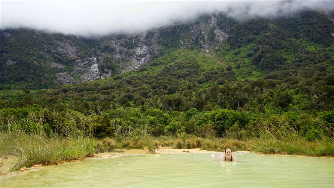
The hot pools are just a short stroll from the hut with fine views of the Sierra Range on a clear day. These pools are a fragile environment so please do not use soaps or shampoo or dig more pools. Always keep your head above the water to avoid the risk of amoebic meningitis.
Understand if you are ready for the Copland Valley Track
Watch the NZ Mountain Safety Council’s walk-through video which takes you through how to prepare for this track. Including facilities, key decision points, hazards and typical conditions for the area.
Access is off SH 6, 26 km south of Fox Glacier. The turn-off to the car park is well signposted on the northern side of the Karangarua River bridge. After turning off, drive approximately150 m down the gravel road to the car park. Close the gate on your way through.
Bus transport may be available but must be booked in advance.
Experience: Suitable for people with limited backcountry (remote area) experience. Watch the Mountain Safety Council video about the Copland Track before you go.
The track will be closed for heavy rain events as side streams on the track become impassable. There is a flood bridge across Rough Creek for emergency use only to exit the valley (located 30 min upstream from the carpark).
Best time to go: Summer and autumn.
Maps: NZTopo50 BX14 Gillespies Beach
Safety
Hazards: Flooded rivers, rock fall, landslide and avalanche.
Rivers and streams
This valley is subject to flooding at any time of year. Do not attempt this trip in severe weather or when heavy rain is forecast. If rivers and side streams are in flood, do not attempt to cross. The Copland River can flood sections of track making it impassable.
Stay safe when crossing rivers
If you plan to cross unbridged rivers, know how to cross safely and be prepared for if you cannot cross.
Do not cross if the river is flooded, you cannot find safe entry and exit points or are unsure it’s safe. Turn back or wait for the river to drop. If in doubt, stay out.
NIWA river flow forecasts: View a video of national followed by regional river flows
Copland Car Park
No camping
There are no camping facilities at the road end.
Take valuables with you
It is recommended that you do not leave any valuables in your vehicle.
Kea are present at the car park
Kea are a native parrot. Their natural range takes them from the sea to mountain tops. They are highly intelligent and inquisitive birds.
Kea can damage cars, items on car roofs, aerials, bikes, motorbikes, helmets, and tramping equipment. Using a car cover is recommended. Loose items should be packed away or covered. Any interesting objects left exposed are likely to attract kea, who will pull it apart to see how it works.
Do not feed the kea as this encourages them to areas like carparks and is harmful to their health.
The forests of the Copland valley are visually dominated by a healthy canopy of southern rātā, a spectacular sight during the summer flowering season. The forest gives way at higher altitudes to the upper montane vegetation of tree daisies and dracophyllums, which in turn give way to the truly alpine habitats of tussock grasslands and native herbs.
Regular possum control has been undertaken since the mid-1980s, and as a result the forest damage is significantly less than in the neighbouring Karangarua valley, which has extensive canopy dieback.
The Copland Track was built by the Tourist and Health Resorts Department to provide a tourist route across the Southern Alps linking the West Coast with the Hermitage, a popular lodge at Mt Cook.
In 1901 New Zealand became the first country in the world to form a government department to develop and promote tourism. Along with places such as Rotorua, the Chateau (Tongariro) and Milford, The Hermitage and the Southern Alps were becoming popular destinations with the growing number of international tourists.
Construction
The track was constructed over several years from c1901-1913. Construction was slow and hampered by labour shortages. The harsh alpine weather made it impossible to work on the track during winter, so work was restricted to the summer months. Work was also delayed by the unstable nature of the landscape and high rainfall in the area. This meant sections of track often had to be rebuilt due to damage from flooding, erosion and landslides.
At first the track was little more than a blazed line through the bush that had the tendency to become quickly overgrown. Eventually the track was widened and developed into a pack track.
There were no other tracks of this scale constructed solely for tourist use on the West Coast. The doggedness with which the completion of the track was pursued by the Government highlights the importance the Copland Track had in their plans for tourism in the South Island.
Welcome Flat hot pools
During the construction of the track, workers came across the natural hot pools at Welcome Flat. This was a great find - thermal attractions were proving popular with visitors and seen by the government as key to stimulating tourism. The route quickly became a popular tourist trip and was one of the key tourist attractions that sustained the fledgling tourist industry in the area.
Nature's in trouble
Thousands of New Zealand’s native species are heading towards extinction. Once they’re gone, they’re gone for good. Nature needs your help.
Stay safe in the outdoors
- Choose the right trip for you. Learn about the route and make sure you have the skills for it.
- Understand the weather. Check weather forecasts.
- Pack warm clothes and extra food. Check gear lists.
- Share your plans and take ways to get help. Leave your intentions with a trusted contact and take a distress beacon.
- Take care of yourself and each other.
Awarua/Haast Visitor Centre
| Phone: | +64 27 303 4890 |
| Email: | haastvc@doc.govt.nz |
| Address: | Haast Junction Corner SH6 and Jackson Bay Road Haast 7886 |
| Hours: | Visitor centre hours and services |
Westland Tai Poutini National Park Visitor Centre
| Phone: | +64 3 752 0360 |
| Email: | westlandnpvc@doc.govt.nz |
| Address: | 69 Cron Street Franz Josef Glacier 7856 |
| Hours: | Visitor centre hours and services |