Mt Arthur/Tableland hunting
Located in Motueka hunting in the Nelson/Tasman region
|
Introduction
Mt Arthur/Tableland is a distinctive area between the Cobb, Karamea and Baton Valleys to the north-west of the Motueka Valley. Red and fallow deer, pigs and goats are present.Species
- Deer - Fallow
- Deer - Red
- Goats
- Pigs
Permit requirements
This hunting area is covered by an 'open area permit' – get it online or from a DOC office.
Seasonal restrictions
Closed for hunting between sunset 22 December and sunrise 9 February.
Dog access
About this hunting block
General information
Mt Arthur/Tableland is a distinctive area between the Cobb, Karamea and Baton Valleys to the north-west of the Motueka Valley, and covers an area of roughly 6,000 ha.
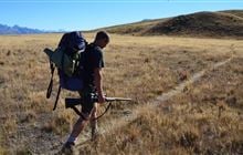
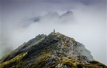
The rolling tussock grassland and mixed beech forest offers a mixture of open grassland and bush hunting. The geology is a mixture of ancient peneplain and marble landforms that were once buried deep in the earth crust.
Winter will see severe frosts and snow fall in the coldest months from June to August. In the summer, temperatures are milder but winter conditions can arrive unexpectedly. Rainfall is around 2500 mm per year and falls throughout the year.
Red deer and fallow deer are found in the area as well as a few pigs and goats.
Access
The access road into the Mount Arthur area (Graham Valley Road) is steep and narrow and prone to corrugations and slips – check any alerts for road status. During the winter months a 4WD vehicle is recommended to access Flora carpark. Chains may be needed if snow and ice are present
The access road is narrow and steep.
It's also possible to access the Tableland from tracks leading from the Cobb Reservoir Road.
Landholders
The Tableland is bordered on three sides by national park whereas private land extends well up the Graham Valley. If you are in any doubt where the private land boundaries are, call into your nearest DOC office for further information.
Maps
Park Map 274-13, Topo50-BP23, BP24, BQ23 and BQ24.
Dogs
Dog are only permitted on the front faces of the Mt Arthur Range, providing a dog permit is obtained, and must not be taken on overnight stays in the park. Great spotted kiwi have recently been reintroduced into the Flora River and a ‘No Dogs’ policy is strictly enforced in this area.
Huts
A number of back country huts are provided in the area from basic huts and rock shelters that are free, to serviced huts that require the purchase of Back Country Hut tickets.
Additional information
Much of the upper and mid regions of the Flora River are under a sustained animal pest control programme managed by a volunteer group known as Friends of Flora. Volunteers check traps on a monthly basis with much of the work taking place off marked tracks.
Contacts
| Motueka Office | |
| Phone: | 0800 275 362 |
| Email: | motueka@doc.govt.nz |
| Address: |
406 High Street Motueka 7120 |
| Postal Address: |
406 High Street Motueka 7120 |
| Full office details | |
| Whakatū/Nelson Visitor Centre | |
|---|---|
| Phone | +64 3 546 9339 |
| nelsonvc@doc.govt.nz | |
| Address | Millers Acre/Taha o te Awa 1/37 Halifax Street Nelson 7010 |
| Hours | See visitor centre hours |