Kaweka Forest Park
Located in the Hawke’s Bay region
|
Introduction
Kaweka Forest Park has alpine shrublands, tussock valleys and beech forests. It offers rafting, canoeing, hunting and fishing, hot springs and tramping for both experienced trampers and day walkers.- Picnic and camping spots are located at roadends.
Find things to do and places to stay Kaweka Forest Park
The Mohaka, Makino and Ngaruroro Rivers are popular fishing rivers for rainbow and brown trout. Trout here breed naturally as opposed to being introduced from hatcheries and they are known for their size and fighting ability.
There is a variety of fishing water available including rapids and bouldery runs of clear water to deep, calm pools.
There is scope for both the novice and experienced; using wet flys, nymphs or spinners.
The Mohaka and Ngaruroro Rivers are two remaining ‘wild and scenic’ rivers in the North Island offering multi-day trips and are not affected by hydro development.
Mohaka River
Commercial rafting companies operate trips on the upper Mohaka, starting from the boundary of Kaimanawa Forest Park and Poronui Station, or from the confluence of the Mohaka and Taharua Rivers. These trips pass through the Te Puia and Mangatutu areas and end where the Mohaka is crossed by the Napier-Taupo highway.
Because of difficulty of access through private land, however, few individual groups raft the upper Mohaka.
A feasible option is the 22 km stretch from Pakaututu Road to the Napier - Taupo highway. This section contains mainly Grade 2 rapids and takes 3 - 4 hours to complete. Entry point is by the bridge over the Mohaka River, about 5 km along Pakaututu Road from the Makahu Road turnoff. A track leads to the left from the Puketitiri side of the bridge down to an entry point to the river.
A second option for a short rafting trip is from the end of Makahu Road to the bridge on Pakaututu road. This section has Grade 2 rapids and takes 2 - 3 hours to complete. Access to the river from the Mangatutu Hot springs is difficult but feasible.
Ngaruroro River
Rafting the Ngaruroro River is a popular wilderness experience. Commercial and private groups use Kuripapango as an exit or entrance point to the river, which is usually rafted in two sections.
The upper river, from Boyd Hut in the Kaimanawa Forest Park to Kuripapango, is a 3 - 4 day trip through the remote country of the Kaimanawa and Kaweka Forest Parks. The rapids are not technically difficult (generally Grade 2 rapids).
A popular short rafting excursion at Kuripapango itself is to travel the Ngaruroro River’s “Oxbow”, putting in at the Cameron Carpark and pulling out at Kuripapango. There are Grade 2 rapids along this scenic stretch of the river.
From Kuripapango downriver is a 1 - 2 day trip, initially through remote gorge country (Grade 2 and 3 rapids), then through farmland (Grade 1 and 2 rapids) to Whanawhana Road.
Kaweka Forest Park is north-west of Napier.
Safety
This is a mountainous area. Visitors should be prepared for sudden weather changes, whiteouts, high winds on the ranges and rapidly rising water levels in rivers and streams. The Puketitiri area is in the rain shadow of the Kaweka Ranges.
Weather forecast
Kaweka J Summit weather forecast – NIWA website
Fires
Extreme fire conditions can exist during summer. The park is a restricted fire area, which means permits to light fires are required all year round.
Kuripapango (Ox Bow) and the Mangatutu campsites have a year round total fire ban for public safety. No fires are permitted in these areas
Maps
The Land Information New Zealand (LINZ) topographical maps that cover the Kaweka Forest Park are:
Topo50 map BH36 - Motutere
Topo50 map BH37 - Rangitaiki
Topo50 map BH38 - Te Haroto
Topo50 map BJ36 - Tawake Tohunga
Topo50 map BJ37 - Kuripapango
Topo50 map BJ38 - Te Pohue
Topo50 map BK37 - Tikokino
Natural vegetation on the eastern facing country has been extensively affected by fire and introduced animals. The former blanket of forest has almost totally gone. In its place are remnants of rapidly regenerating manuka and kanuka.
On the open tops of the Kaweka Range there are sub alpine shrublands, tussock and hardy alpine herbs and flowers. On the flanks of the range red and mountain beech are the predominant trees.
At lower altitudes, in the river valleys, there are pockets of podocarp forest (rimu, miro, matai) and varied broadleaved species such as lacebark, five finger and kohuhu.
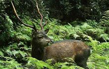
Despite the modification that has occurred several rare, threatened species have been recorded in the area. These include the North Island brown kiwi, New Zealand falcon (karearea), North Island kaka, and blue duck, dactylanthus and mistletoe.
Visitors to the area may be treated to the sight or sound of yellow crowned parakeet, whitehead (popokatea), North Island fernbird (matata), bellbird (korimako), tui, North Island robin (toutouwai), grey warbler (riroriro) tomtit (miromiro), NZ pigeon (kereru), rifleman (titipounamu) kingfisher (kotare), NZ pipit (pihoihoi) fantail (piwakwaka), silver eye (tauhou), welcome swallow, and, in summertime, long tailed cuckoo (koekoe), are all present.
A total of ten native freshwater fish species has been recorded in the Mohaka River.
Learn about the history of Kaweka Forest Park - it goes back to pre-European times. Today, there are several heritage sites - Iron Whare, Manson Hut, and Robson's Lodge.
Contacts
| Ahuriri / Napier Office | |
| Phone: | 0800 275 362 |
| Fax: | +64 4 471 1117 |
| Email: | napier@doc.govt.nz |
| Address: |
Level 2 Dunvegan House 215 Hastings Street Napier 4110 |
| Postal Address: |
PO Box 644 Napier 4140 |
| Full office details | |