Public access to Mount Hikurangi is closed from 12 noon on 31 December to 12 noon on 1 January each year for the Hikurangi Maunga Dawn Event.
The track from carpark to the hut will be closed every October for lambing.
Time:
Car park to Hikurangi Hut: 4 - 5 hr
Hikurangi Hut to summit: 2 - 3 hr
Walk across Pakihiroa station to Hikurangi summit. Yellow markers show the route from the carpark to the hut and most of this section follows a farm track.
Once at the hut, marker poles show the route from the hut up the mountain. However the last 400m up a steep scree slope is unmarked and not maintained – keep left all the way.
Note: Hikurangi Hut is a basic 10-bunk hut available for public use on the track. To make a booking go to www.maungahikurangi.com/book-online.
The track starts 25 km from Ruatoria. Turn off SH 35 onto the Tapuaeroa Valley Road and follow the signs for Pakihiroa Station.
There is a formal car park just below the station manager's house. There is no public vehicle access past this point.
Track condition
Only attempt the track if you have backcountry tramping experience, including good wayfinding skills.
Private farmland
Te Ara ki Hikurangi track crosses private farmland. Leave gates as you find them. Don't disturb stock – keep your distance, and walk around cattle if safe.
The track may be closed for short periods during the year for farming or cultural reasons. All closures will be publicly notified.
Te Runanganui o Ngāti Porou offers tours of the Maui Whakairo (including options for hikers).
Experience required
You need above average fitness, and a high level of experience in backcountry navigation and survival.
What to expect
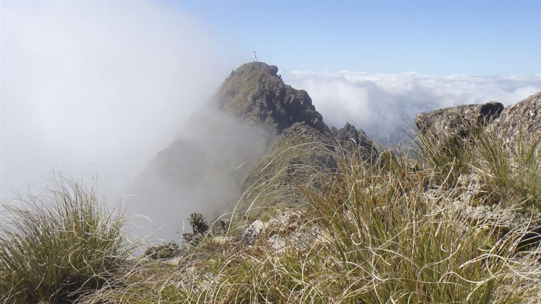
Mt Hikurangi is an alpine environment (1752 m). The weather is unpredictable and can change rapidly. Expect rain, fog, cloud, strong winds, snow and extreme cold at any time of the year. Be prepared to turn back if weather conditions deteriorate.
This track is designed for walking during daylight hours only and is not safe to attempt in poor visibility.
The last 400 m is a scree slope. It's steep with unstable footing. Watch your footing to avoid causing rockfall and injury – extreme care is required. Do not attempt in conditions that are wet, windy, icy or visibility is poor.
What to take
Take warm and waterproof clothing, some form of communication, carry water and food.
Use map NZTopo50 BE44 Te Puia Springs. These can be purchased from local map stockists.
Accommodation
There is a hut available for public use on the track administered by Te Runanganui o Ngāti Porou. Address: 1 Barrys Avenue, Ruatoria 4032, Phone: +64 6 864 9004, Email: info@maungahikurangi.com.
- For hut bookings see www.maungahikurangi.com/book-online
- Check alerts on this page to find out if the track is closed
- Camping is not permitted.
Be aware
No dogs, no guns and no mountain bikes are to be taken onto Pakihiroa Station.
Stay safe in the outdoors
- Choose the right trip for you. Learn about the route and make sure you have the skills for it.
- Understand the weather. Check weather forecasts.
- Pack warm clothes and extra food. Check gear lists.
- Share your plans and take ways to get help. Leave your intentions with a trusted contact and take a distress beacon.
- Take care of yourself and each other.
DOC Customer Service Centre
| Phone: | 0800 275 362 |
| Email: | gisborne@doc.govt.nz |
| Address: | Tūranganui-a-Kiwa / Gisborne Office |