
Whakapapaiti Valley Track
Located in Tongariro National Park and Whakapapa Village area in the Central North Island region
|
Introduction
Winding through stunted beech forest, the Whakapapaiti Valley Track makes its way to the Whakapapaiti Hut. From here you can continue in a loop back to Whakapapa Village.16 km loop
Dog access
Image gallery
-
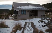
Whakapapaiti Valley Track Image: Wei-Hang Chua | Creative Commons

-
Whakapapaiti Hut Image: Wei-Hang Chua | Creative Commons

-
Whakapapaiti Hut Image: Wei-Hang Chua | Creative Commons


This track can be walked in either direction, but is described going counter-clockwise.
Follow Silica Rapids Track for about 45 minutes to the junction with Whakapapaiti Track.
The track goes through forest then an open tussock-covered area. There is a bridged crossing of Whakapapaiti River, then the track continues up the valley, passing the junction with Mangahuia Track (2-3 hours to campsite).
Further up the valley there is an unbridged river crossing - it may not be possible to cross safely when the river is high following or during rainfall. Whakapapaiti Hut is 10-15 minutes further up the track.
Leaving the hut, the track winds its way through stunted beech forest, then up the valley to the Round the Mountain Track junction. Turn left here towards Bruce Road.
The track zig-zags up and over a moraine ridge with great views of Whakapapaiti Valley and the surrounding landscape. Continue to the Scoria Flat area on the Bruce Road. Form here it is approximately 5 kilometres down the road to Whakapapa Village.
The Whakapapaiti Valley track begins in Whakapapa Village 250 metres above the Tongariro National Park Visitor Centre. The upper section begins 5 kilometres up the Bruce Road from Whakapapa Village.
Stay safe when crossing rivers
If you plan to cross unbridged rivers, know how to cross safely and be prepared for if you cannot cross.
Do not cross if the river is flooded, you cannot find safe entry and exit points or are unsure it’s safe. Turn back or wait for the river to drop. If in doubt, stay out.
 No drones
Unauthorised use of drones is prohibited. You must have a permit to fly a drone.
DOC does not generally approve permits to fly drones in this national park and we do not recommend you apply for one.
Stay safe in the outdoors
- Choose the right trip for you. Learn about the route and make sure you have the skills for it.
- Understand the weather. Check weather forecasts.
- Pack warm clothes and extra food. Check gear lists.
- Share your plans and take ways to get help. Share directly or use the Outdoor Intentions form or Plan My Walk. Take a distress beacon.
- Take care of yourself and each other.
Contacts
| Tongariro National Park Visitor Centre | |
|---|---|
| Phone | +64 7 892 3729 |
| tongarirovc@doc.govt.nz | |
| Address | Whakapapa Village State Highway 48 Mount Ruapehu 3083 |
| Hours | Visitor centre hours and services |