
Ahuriri Valley Track
Located in Ahuriri Conservation Park in the Canterbury region
|
Introduction
This track follows the Ahuriri River. Three huts on route provide several options.14.5 km
Mountain biking
Intermediate: Grade 3Other activities
- Horse riding
Dog access
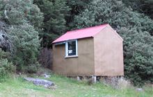
Birchwood Road end to Shamrock Hut
Time: 2 hr one way
Distance: 4 km
The track to Shamrock Hut is generally well-formed but you will need to cross Canyon Creek on the way. There may be the odd washed-out ford to negotiate.
Shamrock Hut to Hagens Hut
Time: 2 hr one way
Distance: 6 km
After Shamrock Hut the track descends towards Ahuriri River. To avoid crossing the river, hug the true right riverbank and make your own way to the hut - there is no formed track. Otherwise, cross the river and use the a well-formed track on the true left of the river. You will need to cross the Ahuriri River again to reach Hagens Hut.
Hagens Hut to Top Hut
Time: 2 hr one way
Distance: 4.5 km
The track is a bit rougher to Top Hut. In good conditions trampers can cross the range into South Huxley Valley or South Temple Valley.
Mountain biking
Birchwood Road end to Shamrock Hut
Track category: Intermediate/Grade 3
Time: 1 - 2 hr
Distance: 4 km
You may need to cross Canyon Creek on foot if high river flow. From there the riding is good until you get to a washed out creek bed. You will need to lower your bike down a small bank to cross the often dry creekbed. It is easy riding again from the creekbed to Shamrock Hut.
Shamrock Hut to Hagens Hut
Track category: Intermediate/Grade 3
Time: 1 - 2 hr
Distance: 6 km
From Shamrock Hut the track descends gently to Ahuriri River. Look out for marker poles on the other side of the river (true left). You need to cross the river and pick up the good track that is marked on the river flats. You then need to cross the river once again to reach Hagens Hut.
Some mountain bikers do carry on to Top Hut (2 hr ride) but it requires a bit of bike pushing as there is no well-formed track.
This is a shared-use track. Follow the mountain bikers code: respect others, respect the rules, respect the track.
Horse riding
The Ahuriri Valley is suitable for horse riding from the start of the 4WD track. Easy access makes the valley a good venue.
Access to the park is via Birchwood Road which leaves SH 8 about 17 km west of Omarama township.
Birchwood Road runs for 21 km up to the park boundary, however Waitaki District Council only maintain it as far as Ben Avon ponds. From there a high clearance 4WD vehicle is required 16 km up to the road end.
Map: NZTopo50 BZ14 Mount Barth
Dogs: dogs must be kept in your vehicle until you reach the conservation park boundary.
Check the flow of the Ahuriri River if you intend to cross before you go. It is safe to cross when the river flow is 18 cubic metres per second (cumecs) or less.
Stay safe when crossing rivers
If you plan to cross unbridged rivers, know how to cross safely and be prepared for if you cannot cross.
Do not cross if the river is flooded, you cannot find safe entry and exit points or are unsure it’s safe. Turn back or wait for the river to drop. If in doubt, stay out.
Stay safe in the outdoors
- Choose the right trip for you. Learn about the route and make sure you have the skills for it.
- Understand the weather. Check weather forecasts.
- Pack warm clothes and extra food. Check gear lists.
- Share your plans and take ways to get help. Share directly or use the Outdoor Intentions form or Plan My Walk. Take a distress beacon.
- Take care of yourself and each other.
Contacts
| Te Manahuna / Twizel Office | |
| Phone: | 0800 275 362 |
| Fax: | +64 4 471 1117 |
| Email: | info@doc.govt.nz |
| Address: |
15 Wairepo Road Twizel 7901 |
| Postal Address: |
Private Bag 951 Twizel 7944 |
| Full office details | |