Styx-Arahura hunting
Located in Hokitika hunting in the West Coast region
|
Introduction
Hunt red deer, low numbers of chamois (in alpine areas) and hares in the Styx-Arahura.Species
- Chamois
- Deer - Red
Permit requirements
This hunting area is covered by an 'open area permit' – get it online or from a DOC office.
Dog access
About this hunting block
General information
The Styx-Arahura is a popular area for hunters and trampers. The two rivers are linked by Styx Saddle and the upper Arahura continues through the Browning Pass to Canterbury. There are several gorges in the Arahura but the Styx is a far more gentle gradient stream.
The upper reaches of the two valleys are a mix of river terraces, clearings and narrow sections but are quite accessible. The Styx and Arahura are fairly small catchments with a few large side streams, steep forested hillsides and tussock tops.
Styx Valley Track is now very rough with numerous slips to be negotiated. These slips are moving after each rain event and can be difficult to cross by inexperienced people.
The alternative via the Arahura Track has a major slip south of Snowball Creek. Caution is advised when crossing this slip.
Carry a PLB or radio. Mobile phone coverage is often poor and should not be relied on.
Access
Access to these valleys is from gravelled roads. The Arahura roadend is reached by taking the Milltown turn off at Lake Kaniere to the start of the walking track immediately across the Arahura road bridge. This track crosses private land initially then after the Cesspool footbridge follows a cut track the length of the valley. There is a side track that leads to Newton Hut. The Milltown Road continues for about 8 km past the Arahura Track start and provides access to areas near the Kawhaka Pass.
Access to the Styx Valley is off the upper Kokatahi to Lake Kaniere Road 500m past the upper Styx Bridge. Through the gate there is a rough farm track that crosses several grassed flats to the start of the marked tramping track that follows the true right of the river to Grassy Flat. Styx saddle is one hour's walk beyond Grassy Flat. From Grassy Flat a steep track leads to Browning Range Bivvy and Lathrop Saddle.
Warning 15 February 2013: The Styx River has cut into a vertical gravel cliff 20 minutes from the Styx car park. To continue up the valley be prepared to cross the river at normal flow below and above this slip. Parties or individuals that are not confident with river crossing should travel through via the Arahura valley.
The alternative via the Arahura Track has a major slip south of Snowball Creek. Caution is advised when crossing this slip.
The Styx Valley Track is now very rough with numerous slips to be negotiated. These slips are moving after each rain event and can be difficult to cross by inexperienced people.
Landholders
The landowner at the Arahura road end allows foot access along the farm track to the Cesspool Bridge, but permission to hunt on the freehold land must be obtained from him. The lower Styx Valley is grazed by cattle but foot access is allowed. Do not disturb stock in either place. Contact Mike Milne +64 27 371 4360.
Maps
NZTopo50 BV19, BV20.
Dogs
All conservation land areas are prohibited to dogs except where authorisation has been granted by DOC. People wishing to take a dog into this area should seek authorisation from the local DOC office. To take dogs across private property you must get permission from the landowner.
Huts
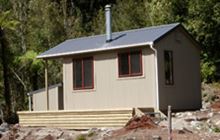
There are several standard or basic DOC huts in the area:
- Lower Arahura Hut
- Newton Creek Hut
- Mudflats Hut
- Harman Hut
- Mid Styx Hut
- Grassy Flat Hut
- Campbell Bivvy
- Browning Range Bivvy
Hunting
- Red deer can be found throughout the area at any time of the year however spring hunting on the grass flats and the Roar is most popular.
- Chamois are found mainly in the alpine areas in low numbers.
- Hares are found throughout.
- Possums are controlled by TBfree in the lower parts of both valleys.
- Feral pigs and goats are uncommon.
Additional information
Avoid disturbing the cattle in the lower Arahura and Styx.
Contacts
| DOC Customer Service Centre | |
|---|---|
| Phone | 0800 275 362 |
| hokitika@doc.govt.nz | |
| Address | DOC offices |


