Leatham Conservation Area (including Wye River) hunting
Located in South Marlborough hunting in the Marlborough region
|
Introduction
The Leatham Conservation Area covers the catchments of the Branch and Leatham Rivers, it is a popular hunting area with red deer, goats, pigs and chamois (in low numbers).Species
- Chamois
- Deer - Red
- Goats
- Pigs
Permit requirements
This hunting area is covered by an 'open area permit' – get it online or from a DOC office.
Dog access
About this hunting block
General information
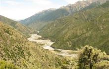
The Leatham Conservation Area covers the catchments of the Branch and Leatham Rivers. It is steep, rugged and rocky.
The higher reaches of the valleys consist of mixed beech and podocarp or pure beech forests, with alpine tussock tops, and scree slopes. The lower reaches are scrubby regenerating bush and wilding pine.
It is a popular hunting area, with red deer, goats, pigs and chamois (in low numbers). Pigs are generally only found in the lower Branch valley. Popular hunting spots include Scott’s Creek in the Branch and Wild Sheep Creek in the Leatham.
The Wye River flows from reserve areas adjoining the eastern side of the Leatham Conservation Area.
Check the weather forecast for Nelson Lakes as well as Marlborough if you are planning a trip to this location.
Access
There is good 4WD access into the area, when the rivers are in low flow. This is via the Leatham Road, which turns off SH63, approx 70 km west of Blenheim. It requires a high clearance, off-road 4WD vehicle and river crossing experience.
Visitors need to take note of weather reports in advance as the rivers are not crossable when flows are medium to high, and the fords can be affected by flood events.
River flow information can be accessed on the Marlborough District Council website.
Access to the Wye
There is a tramping track from the Leatham Road to the Hidden Hut at the top of the Wye River.
Alternatively, access may be available through private property via the Wye River.
Access to the Gosling Stream is via Stronvar Station in the Upper Waihōpai Valley.
Helicopter access
Some areas are not accessible by road or track. Helicopter operators must have a landing concession.
Landholders
No prior permission is required to access the Leatham or Branch Roads.
Wye River and Waihōpai/Gosling access is through private land and requires permission from the landowners. DOC does not have a list of contacts for this area.
Maps
NZTopo50 – BR25, BR26, BS25, BS26
Dogs
Dogs are allowed with a dog permit from DOC's Wairau / Renwick Office.
Permission to take dogs through private property must be obtained from the landowners.
Huts
Leatham
Branch
- Greigs Hut
- Siberia Hut
- Branch Bivvy
- Bottom Misery Hut
- Silverstream Bivvy
- Mid Silverstream Hut
- Top Misery Hut
- Lost Stream Bivvy
Wye
Gosling Hut can be booked by contacting the Marlborough Tramping Club:
Additional information
No additional restrictions apply.
For further mapping and access information refer to Walking Access Aotearoa or DOC maps.
Contacts
| Whakatū/Nelson Visitor Centre | |
|---|---|
| Phone | +64 3 546 9339 |
| nelsonvc@doc.govt.nz | |
| Address | Millers Acre/Taha o te Awa 1/37 Halifax Street Nelson 7010 |
| Hours | Visitor centre hours and services |


