This track is part of Te Araroa Trail.
The track is flat and easy to walk. It is within easy walking distance of Waikanae Beach.
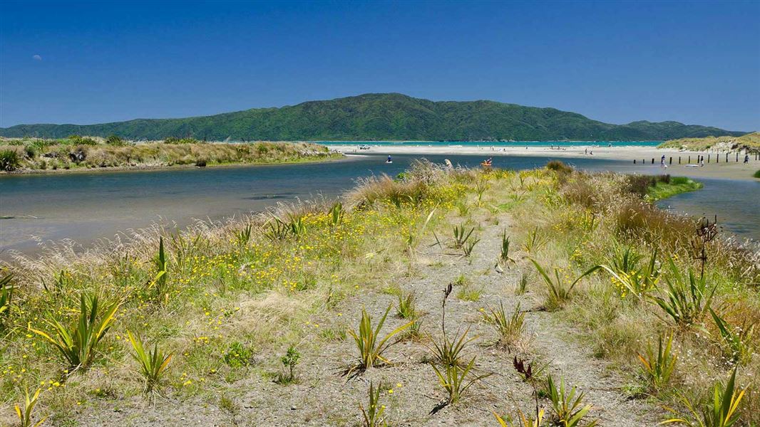
This nationally-significant reserve is connected to the Tararua Forest Park, Kapiti Marine Reserve and Kapiti Island Nature Reserve.
It provides a rare sequence of protection for animals which move between sea, river and land habitats. It also protects a natural mosaic of freshwater lakelets, saltwater lagoons and marshes, tidal sand flats and sandy beach at the mouth of the Waikanae River.
The track is accessed from multiple entry points in Waikanae - at Manly Street, Takahe Drive, Otaihanga Road end, or the Otaihanga Boat Club
There is good parking on Manly Street and on Makora Road near the boat club or in the Otaihange Domain.
Public transport: the 280 bus connects Waikanae Station with the Tutere Street shops and northern access to the Waikanae Estuary Scientific Reserve.
Beware of soft sand near water. The changing course of the river affects the water table beneath the sand and can cause quicksand conditions.
To protect the reserve’s special ecological values, restrictions include:
- no vehicles or cycling in the reserve
- no horses apart from on the dunes track from the Tutere St car park to the beach
- no dogs, except with on leads on.
Species in the reserve
The river and estuary are a tidal home and airport to a variety of waders and sea birds. More than 60 species of birds are found there, including banded dotterel, pukeko, dabchick, and variable oystercatcher. They occupy the sandspit where the river affords some protection from the increasing numbers of cats, ferrets, dogs and vehicles on the other side of the reserve. Flocks of white-fronted terns, shags, gulls and penguins roost on land but rely on the sea for small fish and shrimps.
Domestic travellers – such as wrybills and black-fronted terns from Canterbury – stop over, as do the international migratory birds, such as godwits and knots from Siberia.
Royal spoonbills have nested on Kapiti Island since the early 1990s, and they regularly visit to feed in the shallow waters of the estuary. The birds depend upon the constant movement of the river and the tide which opens up twice a day to reveal a feast of worms, shellfish and crabs. If the river and sand is stabilised too much these intertidal flats will dry out, forcing the birds to leave.
As a part of their life cycle, many native fish species require both freshwater and saltwater. For example, the whitebait species mature in the freshwater, spawn in the inter-tidal zone and their young go out to sea to return as whitebait. Eels mature in the river, go out to sea to spawn and return as transparent glass eels.
Five species of galaxiid fish make up the whitebait catch. The īnanga, kōaro and banded kōkopu are the most common but the giant and short-jawed kōkopu are rare.
Modification of the catchment area, such as the removal of stream vegetation, urban development, increased sediment and pollutant levels, and obstructions to fish passage such as culverts have impacted on the fisheries values. Fish need unimpeded access from the marine environment to the upper catchment areas. Some species use the river as a highway, sometimes climbing huge waterfalls to reach their preferred habitat.
Living carpets
Carpets of remuremu, Selliera radicans, grow in the firm mud along the waters of the estuary. They vary according to the flow of the river and the development of the wetland. The mosaic of tidal sandflats, sand dunes, salt marshes and lakelets provide a home for this and more vulnerable plants such as two regionally rare carex species. Many of these plants have disappeared because they are very sensitive to changes in water quality and introduction of weeds.
River's end
From the Tararua Range, the Waikanae River once flowed through dense forest which reached almost to the sea. At a point near the present railway bridge, the river split into two channels flowing through swamp forest and salt marsh, meeting again at the dunes and lakelets of the estuary. Here they cut through sandhills, some 10 metres high. The river now flows through a single channel to the sea.
Middens, observation posts, pā and burial grounds are reminders of early Māori who moved through the area. Ngāti Apa, Rangitāne and Muaūpoko were followed by Ngāti Toa, Te Ātiawa and Ngāti Raukawa.
The estuary is the site of the 1839 Battle of Kuititanga where Te Atiawa, who had established pa on both sides of the estuary, fought Ngāti Raukawa, forcing them to flee to Ōtaki. The area is sacred to the people of Ātiawa ki Whakarongotai who are tangata whenua of this area.
In 1886 the Manawatū Railway opened the coast to more European settlement. Flaxmilling and farming settlements ripped away much of the coastal forest, exposing the river’s flanks to erosion. Since then, housing, flood protection, gravel extraction, stormwater, farm waste and industrial discharges have further diminished the power of the river.
Wellington/Kapiti information
| Phone: | +64 3 546 9339 |
| Email: | nelsonvc@doc.govt.nz |
| About: | Whakatū/Nelson visitor services provide information for this area |