There are two tools to help you assess avalanche danger:
- New Zealand Avalanche Advisory (NZAA) - based on the stability of snow and changes with the weather.
- Avalanche Terrain Exposure scale system (ATES) - based on terrain and does not change with the weather.
Anytime that snow and steep slopes are combined there is potential for an avalanche.
New Zealand Avalanche Advisory (NZAA)
The best way to understand the avalanche danger in Fiordland National Park is to check the New Zealand Avalanche Advisory (NZAA). The NZAA provides daily assessments of avalanche likelihood at different elevation bands and aspects, primary and secondary dangers, along with recent avalanche activity, current snowpack conditions and mountain weather. The NZAA is also available at DOC visitor centres.
The NZAA is provided by the Mountain Safety Council (MSC) as an advisory only. We recommend you also check the Fiordland National Park weather forecast as part of your trip planning.
Avalanche Terrain Exposure Scale (ATES)
The Avalanche Terrain Exposure Scale (ATES) rates avalanche terrain based on the angle and shape of the ground or the number of established avalanche paths.
How ATES applies in Fiordland National Park
Fiordland National Park covers 1.3 million hectares of remote mountainous terrain and avalanche conditions can vary throughout. The majority of the avalanche threat is on several of Fiordland’s tracks and all the Great Walks (Milford, Routeburn and Kepler Tracks.) It is common to receive over 15 metres of snow in the northern area of the park during the winter and spring months.
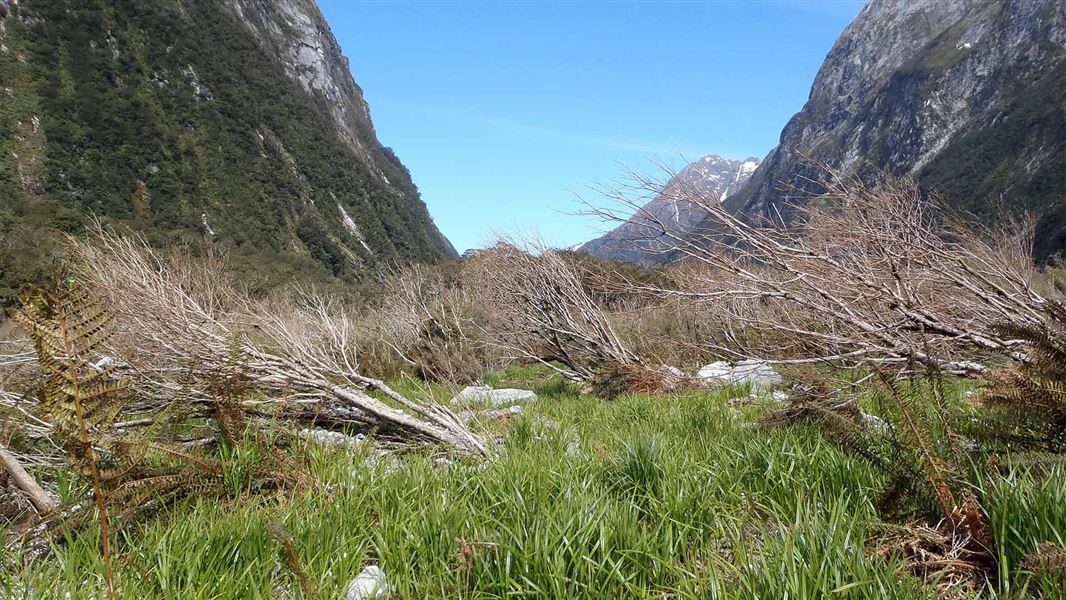
The majority of Fiordland tracks meander along valleys that are clear of winter snow. However, due to the surrounding steep-sided mountains and wet snow, avalanches have a great impact on valley floors, usually travelling at speed and leaving little chance of avoidance. Avalanche run-out zones in valley floors are usually self-evident, with little vegetation and clearings in these zones.
Great Walks
There is avalanche threat on all of the Great Walks in the area. For information see:
- Milford Track: May to late October
- Routeburn Track: May to early November
- Kepler Track: May to late October
ATES ratings for popular tracks in Fiordland National Park
You need to have the right level of experience to safely travel simple, challenging or complex terrain. To find out what experience is needed for each, check our avalanche safety page.
Simple
- Dusky Track (excluding the alpine areas)
- West Arm to Percy Saddle to bush line
- Hanging Valley Track, Deep Cove
- Kepler Track (below Luxmore Hut and below Hanging Valley Shelter)
- East Branch Eglinton (Milford Road)
- Boyd Creek to bush line (Milford Road)
- George Sound Track
- Pass Creek (Hollyford Road)
- Key Summit
- Divide to Lake Howden
- Deadmans Track (not beyond the Routeburn Track)
- The Gantry (not above the Gantry/Hollyford Road)
- Tutoko Valley (not beyond Leader Creek Junction)
- Hollyford/Pyke Track
- Routeburn Falls Hut to Glenorchy road end
- Milford Track (between Glade Wharf and Clinton Hut)
- Milford Track (between Sand fly Point and Giant Gate Falls)
Challenging
- Dusky Track alpine areas (Centre Pass and Lake Roe)
- Borland Road (Borland Lodge to South Arm)
- Percy Pass (above bush line to Borland Road junction)
- Wilmot Road
- Mavora, Livingstone and Snowdon Ranges
- Lake Marian (Hollyford Road)
Complex
- Takitimu Mountains
- Hunter Mountains
- SW Fiordland
- Kepler Mountains/Jackson Peaks
- Kepler Track (above Luxmore Hut and Hanging Valley Shelter)
- Serpentine Range, Ailsa Mountains and Humboldt Range in Fiordland/Mt Aspiring National Parks area
- Homer Saddle Nature Walk
- Routeburn Track (Lake Howden Hut to Routeburn Falls Hut)
- Mistake Creek, Hut Creek (Milford Road)
- Falls Creek (Milford Road)
- Dore Pass
- Milford Track (between Clinton Hut and Giant Gate Falls)
- Gertrude Valley
- Grave – Talbot Pass Track
- Darran Mountains
- Moraine Creek (Hollyford Road)
Be avalanche aware!
If you are going into places avalanches could occur, make sure you:
- have checked the ATES class for where you want to go and the NZAA for the avalanche rating
- have the skills for the ATES class you are going into
- take an avalanche transceiver, a snow shovel and a probe. Know how to use these tools.