Tiritiri Matangi has been the site for one of the Hauraki Gulf's most important aids to navigation, the Tiritiri Light, for over a century.
Located at the entrance to the inner Hauraki Gulf, Tiritiri Matangi was an ideal base for early Māori, who relied on the coast for food. The island was settled by Kawerau-ā-Maki, an iwi who built the pā (earthwork fortification) from which the island takes its name. Ngāti Paoa later established the Papakura Pā.
Māori history
In Māori tradition Tiritiri Matangi island is one of the floats of an ancestral fishing net. It is named after a Kawerau pā on the island. The Kawerau people occupied the island from very early times to the 1820s, and again briefly in the 1830s-50s. Ngāti Paoa also occupied the island and built a second, smaller pā known as Papakura towards the northern end of the island. Ngāi Tai ki Tāmaki and the Marutūāhu iwi also have ancestral links with Tiritiri Matangi.
There are a number of archaeological sites on Tiritiri Matangi, now mostly covered by regenerating vegetation but still intact below the ground surface. In addition to the two pā, they include whare (house) terraces, food storage pits, and midden (food refuse) sites.
Archaeological excavation of a midden site found during the construction of the wharf showed that Māori were living on the island by the 14th century and catching marine mammals, coastal birds, sharks, rays and other fish for food. By the beginning of the 19th century the catching and drying of sharks for later consumption had become an important seasonal activity in the waters north of Tiritiri Matangi.
European farming
The forest on Tiritiri Matangi was partially burned off in pre-European times. European farmers grazed livestock on the island from the early 1850s. Farming operations were centred around Hobbs Beach, where there was a woolshed, cottage, boatshed, sheepyards and cattle run.
The island continued to be farmed until the 1970s and retained little of its original vegetation. Since 1984 Tiritiri Matangi has been transformed by a community-based habitat restoration programme and is now home to a range of threatened bird species.
Lighthouse settlement
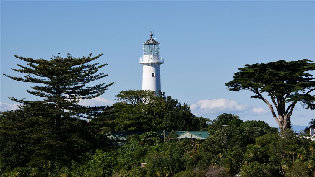
The Tiritiri lighthouse complex is one of only a few surviving lighthouse settlements in New Zealand, and the only one easily accessible to the public.
Built in 1864, the lighthouse is the New Zealand's oldest operational – and Auckland's first – lighthouse station.
It is made of cast iron pre-fabricated in Britain and brought out by ship in sections which were bolted together on site. Over 21 m tall and 4.7 m in diameter at the base, it was initially painted bright red.
The Tiritiri Matangi light incorporated the most modern lantern design and lamp of its period and has been regularly upgraded as new energy sources and technologies were adopted.
Originally fuelled by Colza (rapeseed) oil it was converted in 1880 to paraffin. In 1926 an automatic acetylene light was installed and the lighthouse staff reduced by two, but a watched light was reinstated in 1949 when work began on the electrification of the island.
In 1965 a Xenon gas lamp, equivalent to 11 million candlepower and reputed to the brightest light in the southern hemisphere, was fitted. It was replaced in 1984 by a less powerful quartz iodine light because of problems in obtaining replacement bulbs. In 1990 the light was solar powered and fully automated and the lighthouse de-manned.
Two small cottages for the lighthouse keepers were built in 1864 but replaced with larger houses in 1918. The new houses were a standard Marine Department design first used for the Cape Brett lighthouse in 1908. They are still used (with some alterations), one by the Ranger and the other for volunteers and visitors. Other buildings were progressively added to the complex as technology advanced and requirements changed. Many of these have survived.
Foghorns and signals
In 1898 a Slaughter's Cotton Powder fog station with foghorn and gun cotton store was built on the eastern cliffs. The apparatus involved a descending counterweight and a circular revolving steel plate carrying individual steel encased cartridges which were detonated to produce an explosion audible up to 7 miles (11 kilometres) away. The gun cotton store and remains of the mechanism still survive.
A concrete building southeast of the lighthouse contains the 1935 diaphonic foghorn which replaced the gun cotton foghorn. It was operated by a simple compressed air system. Diesel motors ran a compressor which filled a boiler with a reservoir volume of high-pressure air. This was released through several valves operated by a rotating eccentric cam. Each time the cam lifted the valve a measured volume of air would pass through the diaphone. The diaphonic foghorn was in turn replaced by an electronic version, now also obsolete.
The signal station immediately to the east of the lighthouse was built in 1912 for the Auckland Harbour Board, its purpose to signal ships approaching the port to see if they needed a pilot. A workshop and engine house to the north of the lighthouse dates from the 1950s.
World War II
The island was occupied by the Ministry of Defence between 1940 and 1945 as part of the coastal defence network guarding Auckland harbour and its approaches. A Port War Signal Station to identify approaching ships shared facilities with the Harbour Board initially but shifted to the centre of the island in 1942.
A Fortress Observation Post linked to the Whangaparāoa, Waiheke and Motutapu defences was built in 1940-41 to the east of the lighthouse. Remnants of these structures still survive.