7 km return via same track
About the walk
- Auckland and Hauraki Gulf panoramas
- Pōhutukawa forest and rare native birds
- Steady uphill climb over rough volcanic rock
From Rangitoto Wharf, Rangitoto Summit Track takes you up the dormant volcano of Rangitoto to Summit Lookout.
You can take a side trip around the crater rim or explore lava caves high up on the volcano – a great option for kids. Allow plenty of extra time for side trips and rest stops.
For access to Summit Lookout from other parts of the island, see Rangitoto Island longer walks.
Rangitoto Summit Track
2 hr / 7 km (return)
Easy to intermediate walking track
From Rangitoto Wharf, pass through the waharoa/carved gateway representing the ancestor Peretū.
It’s a short walk from the orientation kiosk to the start of Rangitoto Summit Track. Take the signposted track on your left, just past the historic Scouts bach.
The track leads you through volcanic lava fields and the world’s largest pōhutukawa forest to the summit/tihi of Rangitoto.
It’s a steady uphill walk with:
- 250 m of height gain
- rough and uneven volcanic terrain
- loose, slippery gravel and stones
- little shade on a hot day.
A viewing platform at the junction with Crater Rim Track gives you a unique perspective into Rangitoto’s 60-metre-deep crater, forested with pōhutukawa and rewarewa.
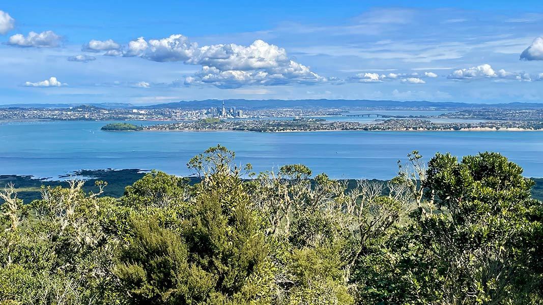
From here, it’s 2 min to Rangitoto Summit Lookout – a great picnic spot. You’ll get panoramic views of Auckland/Tāmaki Makaurau and the Hauraki Gulf/Tīkapa Moana. There’s seating and a historic fire command post – a remnant of the island’s military history.
You can complete the Crater Rim Track before returning to Rangitoto Wharf the same way you came.
Side trips
Crater Rim Track
20 min / 850 m (loop)
Easy to intermediate walking track
Circle Rangitoto’s volcanic crater on this rewarding side trip. You’ll see remnants of the island’s military history too.
Lava Caves Track
15 min / 500 m (one way)
Easy to intermediate walking track
Lava Caves Track is signposted from Summit Track on your right (going up). The turnoff is 45 min from Rangitoto Wharf, and 15 min from the summit.
The track leads to natural tunnels and caves formed during an eruption of Rangitoto.
Alternative routes
Wilson’s Park Track
1 hr / 1.4 km (one way)
Easy to intermediate walking track
Wilson’s Park Track is signposted from Summit Track on your left (going up). The turnoff is 40 min from Rangitoto Wharf.
The track is an alternative, longer route to Summit Lookout and has good shade for hot days. It passes through lava fields with uneven surfaces and loose stones.
Rangitoto Island lies in the Hauraki Gulf/Tīkapa Moana, close to Auckland city. It can only be accessed by ferry, boat and kayak.
Rangitoto Wharf, at the island’s southern end, is the arrival point for public ferries. From here, it’s a short walk to the start of Rangitoto Summit Walk.
Keep Rangitoto pest free
Check, clean and seal your gear to make sure you don’t bring pests, soil and seeds.
Ferry
Rangitoto Wharf is:
- 25 min from Queens Wharf, in downtown Auckland
- 20 min from Devonport, on Auckland’s north shore.
Allow plenty of time to get back to the wharf so you don’t miss your return ferry.
Water taxi and charter boat
You can arrange a water taxi or charter boat to drop you at Rangitoto Wharf.
Private boat
Private boats can load and unload passengers at:
- Rangitoto Wharf, for access to Rangitoto Summit Track
- Islington Wharf, on the island’s eastern side.
Private boats cannot be moored at either wharf.
Kayaks
Experienced kayakers can reach Rangitoto Wharf by kayak. It takes about 2 hr from Devonport or Takapuna Beach.
Kayak tours and hire from central Auckland are also available.
Safety and hazards
- Rough terrain: The track crosses lava fields with rough and uneven surfaces and loose gravel. Wear sturdy footwear with good grip.
- Lava caves: The lava caves are dark with low ceilings, jagged rock and uneven surfaces. Bring a torch, mind your head and keep children close. Rocks inside the caves are unstable – keep off.
- Wasps: Wasps and wasp nests may be present. Bring antihistamines if you are allergic to wasp stings.
When to go
- Black volcanic rock reflects intense heat. Come prepared for very hot temperatures, especially in summer.
- Weather on Rangitoto Island changes quickly. Check the weather forecast before you go, and be prepared for wet and windy conditions year-round.
- Visit in December and early January to see the world’s largest pōhutukawa forest in bloom.
Plan your visit
- Bookings are not required for Rangitoto Summit Walk.
- Toilets are located at Rangitoto Wharf and on Rangitoto Summit Track, near the summit. No accessible toilets are available.
- Food and drinking water are not available on Rangitoto.
- Shelters with seating are provided near Rangitoto Wharf. There is also seating at the first viewpoint and Summit Lookout.
- Camping is not permitted. Historic baches are available to book for overnight stays through Rangitoto Island Historic Conservation Trust.
- Mobile phone coverage is unavailable in places.
What to take
- Packed lunch and snacks
- 1 to 2 litres of drinking water per person
- Sun protection
- Warm and waterproof clothing
- Sturdy footwear with good grip
- Torch for exploring the lava caves
For a complete list, see Day Hikes gear list.
Care for nature
- Keep Rangitoto pest free. Check, clean and seal your gear to make sure you don’t bring pests, soil and seeds.
- Rubbish bins are not provided on Rangitoto. Take your rubbish with you.
- A total fire ban is in place. No fires, cigarettes, BBQs or cookers are permitted.
- Rangitoto is in the Hauraki Gulf Marine Park. If you’re heading out on the water, follow all marine protection rules.

Rangitoto was declared pest-free in 2011. It’s now home to rich bird and plant life, and the world’s largest pōhutukawa forest.
Rangitoto Island nature and conservation
Birds
Rangitoto is a safe haven for native birds, including threatened species rare on the mainland.
On Rangitoto Summit Track, you may see or hear:
- tīeke/saddleback
- kākā
- kākāriki
- bellbird/korimako
- whitehead/pōpokotea
- tūī.
Closer to shore, you may see:
- New Zealand dotterel/tūturiwhatu
- variable oystercatcher/tōrea.
Plants
More than 200 species of native trees and flowering plants grow from the inhospitable lava fields on Rangitoto. You’ll see:
- pōhutukawa
- mingimingi
- koromiko
- kidney ferns
- Kirk’s daisy (an epiphyte rare on the mainland).
Many plants on Rangitoto form unusual hybrids or have adopted strange behaviours because of the lack of soil and scorching heat.
Origins
Rangitoto erupted from the sea 600 years ago. It’s the youngest volcano in Auckland/Tāmaki Makaurau, and the biggest.
The full name of Rangitoto is Te Rangi-i-totongia-ai-te-ihu-o-Tamatekapua (‘the day the blood of Tamatekapua was shed’).
Tamatekapua was chief of the waka/voyaging canoe Te Arawa. He fought a major battle on Rangitoto at Islington Bay against resident iwi/tribe Tainui.
Military history
Rangitoto’s position at the entrance to Waitematā Harbour made it an important part of Auckland’s military defences between 1935 and 1957.
The historic fire command post at the summit has information panels explaining the island’s military history.
Check you are pest-free
Check, clean, and seal your gear to ensure you don't bring pests, soil, and seeds.
Auckland information
| Phone: | +64 7 867 9080 |
| Email: | kauaerangavc@doc.govt.nz |
| About: | Kauaeranga Visitor Centre provides visitor information for this area |