17.2 km one way return via same track
Raspberry Creek car park to Aspiring Hut
Time: 2 hr – 2 hr 30 min
Distance 9 km
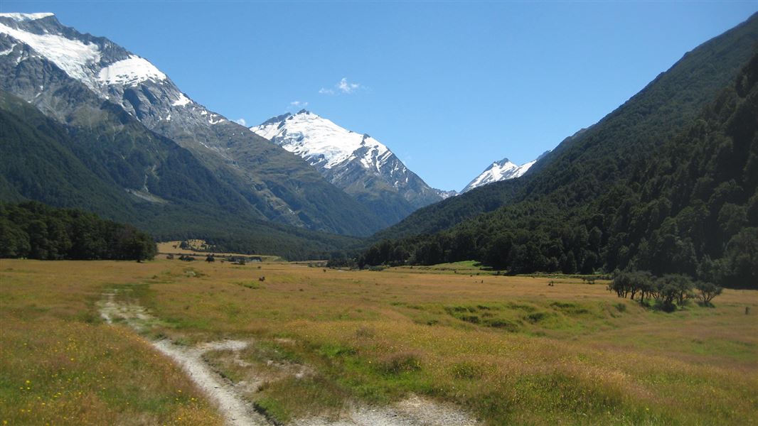
A great first overnight tramp for families with younger children, the walk to Aspiring Hut is mainly over grassed farm flats with a couple of easily negotiated small bluffs that give great views up and down the valley.
The locked historic Cascade Hut managed by the New Zealand Alpine Club can be seen from the last bluff. Aspiring Hut is twenty minutes beyond this.
Aspiring Hut to Pearl Flat
Time: 1 hr 30 min
Distance: 5 km
The track has eroded at the head of Shovel Flat. Proceed with caution and allow extra time. Follow the orange poles towards the bush, instead of following the riverbank. After 400 m, you will reach Pearl Flat.
At Pearl Flat, the West Matukituki Track connects with French Ridge Track and Liverpool Track.
Warning: Challenging avalanche terrain between Rough Creek (just beyond Aspiring Hut) and the intersection with the Liverpool Track can make travel hazardous from late autumn to early summer. Avalanche debris may reach the valley floor at Shovel Flat, do not camp there.
Pearl Flat to head of the valley
Time: 2 hr
Distance: 3.2 km
From the top of Pearl Flat the track enters the bush on the West Matukituki River’s true right. 10 minutes up valley from the Liverpool Swing Bridge, cross the French Ridge Swing Bridge to the beginning of the French Ridge Track.
After a climb of 100 m, a track branching off to the left sidles through beech forest before reaching open scrubby country – approximately 500 m upstream and 50 m from the river from this point is Scotts Rock Biv, a small and not entirely waterproof rock shelter marked with a cairn on top. Easy open travel leads from the biv back across the river to the head of the valley.
The route beyond the head of the valley to Bevan Col is for experienced trampers and climbers only.
Warning: Complex avalanche terrain between the bridge at the beginning of the Liverpool Track and the head of West Matukituki Valley can make travel hazardous from late autumn to early summer.
The track starts at the Raspberry Creek car park, 54 km west of Wanaka on the Wanaka-Mount Aspiring Road. The drive takes about 1 hour 20 minutes. The last 30 km are gravel.
There are several creeks to drive through in the last 10 km of the road. These rise in heavy rain and can become impassable to 2WD and sometimes 4WD vehicles. After 24 hours of little or no rain, the fords are usually passable for 2WD vehicles, including campervans.
Check the weather forcast on NIWA website.
Drive slowly through the fords and, if in doubt, get out of your vehicle to check the depth of them beforehand. If needed, you can park before the final two fords and walk the remaining few hundred metres to the car park – just make sure your vehicle is safely off the road and not blocking any farm gates.
After particularly heavy rain, the road is prone to washouts, sometimes requiring it to be closed for repairs.
Marked with warning signage, Shovel Flat is an area where avalanche debris may reach the valley floor, camping at Shovel Flat is not recommend.
There has been rockfall near Wishbone Falls, proceed with caution.
Bad weather
The weather can change rapidly in New Zealand. Hypothermia is a real risk even in summer. Be prepared by having warm, waterproof, windproof clothing and the appropriate footwear. Whiteout conditions caused by snow or low cloud may be present. Check the Mount Aspiring National Park weather forecast – NIWA website.
Swing bridges
There's a limit to the number people allowed on the swing bridges at any one time – be prepared to wait at each end if numbers allowed have been reached.
Private property and permissions
This track crosses private land. There is no camping until the conservation area boundary.
Respect the landowner's livestock and property:
- stay on the marked track until you reach the conservation land
- leave gates as you find them
- use stiles where provided
- keep your distance from livestock.
Landslide hazard: Aspiring Hut sits in a known landslide debris path which poses a potential hazard to people at the hut and campsite. The risk may increase following earthquake events or very heavy rainfall. A temporary closure procedure for Aspiring Hut will be activated when heavy rainfall is forecast.
There may be avalanche danger
Avalanches usually occur from May to November in Wakatipu, Wānaka and Central Otago.
The greatest risk is in areas with avalanche terrain rated as 'challenging' or 'complex' on the Avalanche Terrain Exposure Scale. There is challenging and complex terrain in West Matukituki Valley:
- West Matukituki Valley between Rough Creek (just beyond Aspiring Hut) and the intersection with the Liverpool Track.
- Upper West Matukituki Valley from the bridge at the beginning of the Liverpool Track to the head of the valley.
Avalanches can occur outside of these areas but are less frequent.
Stay safe in the outdoors
- Choose the right trip for you. Learn about the route and make sure you have the skills for it.
- Understand the weather. Check weather forecasts.
- Pack warm clothes and extra food. Check gear lists.
- Share your plans and take ways to get help. Leave your intentions with a trusted contact and take a distress beacon.
- Take care of yourself and each other.
Wānaka Tititea/Mount Aspiring National Park
Visitor Centre
| Phone: | +64 27 269 6871 |
| Email: | wanakavc@doc.govt.nz |
| Hours: | Visitor centre hours and services |