15 km one way return via same track
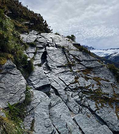
The track has steep, rock slab terrain to navigate.
Image: DOC
Raspberry Creek car park to Pearl Flat
Time: 3 hr 30 min - 4 hr
Distance: 14 km
Follow the West Matukituki Track from Raspberry Creek car park to Pearl Flat.
Pearl Flat to Liverpool Hut
Time: 2 hr - 2 hr 30 min
Distance: 1 km
From Pearl Flat, cross the swing bridge at Liverpool Stream. The track to Liverpool Hut (1,100 m) is a demanding, steep and often slippery climb to the bushline. The track requires you to pull yourself up using tree roots and navigate rock slabs. The track is recommended for experienced trampers only.
Above the bush the track initially leads across steep exposed shingle, rock and tussock terrain before bearing left up an easier tussock slope to reach a knoll overlookingthe hut. Note: When the hut is first sighted, do not sidle across to the hut below this knoll.
The track starts at the Raspberry Creek car park, 54 km west of Wanaka on the Wanaka-Mount Aspiring Road. The drive takes about 1 hour 20 minutes. The last 30 km are gravel.
There are several creeks to drive through in the last 10 km of the road. These rise in heavy rain and can become impassable to 2WD and sometimes 4WD vehicles. After 24 hours of little or no rain, the fords are usually passable for 2WD vehicles, including campervans.
Check the weather forcast on NIWA website.
Drive slowly through the fords and, if in doubt, get out of your vehicle to check the depth of them beforehand. If needed, you can park before the final two fords and walk the remaining few hundred metres to the car park – just make sure your vehicle is safely off the road and not blocking any farm gates.
After particularly heavy rain, the road is prone to washouts, sometimes requiring it to be closed for repairs.
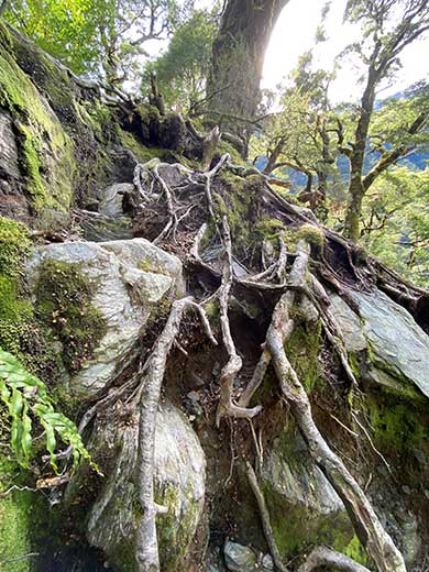
A tree root section on the track.
Image: DOC
- The track requires you to pull yourself up using tree roots and climb up rock slabs. One section is particularly exposed. The track is suitable for experienced trampers only and hiking boots/shoes are essential.
- Tussock and rock can be treacherous and slippery when wet or covered in snow.
- Plan properly and ensure that you follow the outdoor safety code.
- Overnight trampers need a sleeping bag, cooking utensils and sufficient food, warm and waterproof clothing – including gloves and hat. The track is steep and technical. It is recommended you carry only what you need - a lighter pack will make your tramp more enjoyable.
- Good fitness and equipment make all the difference to enjoying your trip, especially as unpredictable weather patterns mean that cold temperatures, snow, strong winds and heavy rain can occur at any time of the year. These valleys aren’t closed in winter, but snow can make travel difficult and dangerous.
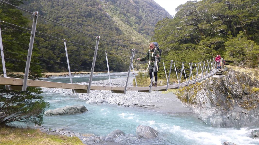
Swing bridges
There's a limit to the number people allowed on the swing bridges at any one time – be prepared to wait at each end if numbers allowed have been reached.
Shovel Flat erosion
The track has eroded at Shovel Flat. Proceed with caution and allow extra time. If the river is high do not attempt to pass through the river, detour through the bush instead.
Be avalanche alert
This area has terrain that can produce avalanches that cross the track, usually from May into November. View avalanche information and the terrain rating for this track.
Stay safe in the outdoors
- Choose the right trip for you. Learn about the route and make sure you have the skills for it.
- Understand the weather. Check weather forecasts.
- Pack warm clothes and extra food. Check gear lists.
- Share your plans and take ways to get help. Leave your intentions with a trusted contact and take a distress beacon.
- Take care of yourself and each other.
Wānaka Tititea/Mount Aspiring National Park
Visitor Centre
| Phone: | +64 27 269 6871 |
| Email: | wanakavc@doc.govt.nz |
| Address: | 1 Ballantyne Road Wānaka 9305 |
| Hours: | Visitor centre hours and services |