This project recognises the correct spelling for traditional Kāi Tahu names like Taiari, Waihora and Māniatoto in accordance with the Kā Huru Manu atlas. Other spellings for these places, including Taieri, may be used in official place names and appear on maps.
Catchment action plan
A process to develop a catchment action plan (CAP) for the Taiari River began in 2025 and is scheduled for completion in November 2026.
The CAP builds on existing work and planning to understand, protect and manage the Taiari catchment. It is being developed through a series of workshops where members of an integrated catchment group work together to create a shared environmental, cultural and socioeconomic vision. The group is made up of 30 people representing mana whenua, agencies, scientists, environmental organisations, members of the community and others.
Otago Regional Council has already created CAPs for the Upper Lakes and The Catlins. The Taiari plan will follow the same process and the Open Standards for the Practice of Conservation framework.
Read more about the Taiari CAP
Surveys and reports
Kanakana in the Taiari catchment
A summary of a survey to re-assess the current distributions of kanakana (Geotria australis, piharau, pouched lamprey) in the Taiari River catchment using environmental DNA sampling and kanakana pheromone detection techniques. The data collected will inform the management of critical habitats required for kanakana and delineate priority catchments for future annual monitoring.
Vulnerability of freshwater ecosystems and species to climate change
The Taiari River has a diverse range of freshwater habitats and species, some of which are found nowhere else. This report describes how climate change is likely to affect these habitats and species:
- Sea-level rise and extreme weather could cause plants in the Lake Waipōuri/Waihora wetland complex to die, and shift the lakes to a more muddy, unhealthy system.
- More rain may increase the amount of water in streams during extreme storms. This could allow trout to enter areas where rare native fish are present and wipe out their populations.
The report also outlines options to mitigate the effects of climate change.
Opportunities to increase climate change resilience in Taiari upland wetlands
This report looks at the catchment’s wetlands above 600 m and what options are available now to help them stay healthy in the long term, even as conditions change. Controlling invasive woody weeds (like wilding pines and willows) and browsing animals (like pigs, deer, goats and rabbits) were the top priorities in a cost-benefit analysis.
The unique upland wetlands include peat-forming bogs and fens, herb fields, areas of red tussock, snowbanks and tarns. They provide habitat for a diverse range of native plants, bugs, lizards, fish and birds, many of which are found nowhere else.
Read the report: Management opportunities to increase climate change resilience in the Taiari upland wetlands, 2025 (PDF, 3,205K).
Read a summary of this report: Strengthening Taiari wetlands as climate changes (PDF, 909K)
Impacts and risks of climate change on the catchment
This report provides detail of projected changes in the climate of the Taiari River area by sub catchment (Māniatoto basin, Strath Taiari and Lower Taiari Plain). These include:
- more dry days and less water in the river and its tributaries
- increasing air temperatures, more extreme hot days and fewer frosts
- increased average rainfall, with more intense events – extreme flooding is expected more often.
Read the report: Climate change impacts and risks for the Taiari River catchment (PDF, 18, 671K)
Matatū ki te taiao, climate resilience strategy
The development of matatū ki te taiao was identified as a central component of Te Mana o Taiari. An initial hui rautaki (strategy workshop) identified values held by the community and principles for resilience planning. Future hui will be held to co-design a work programme for climate resilience and adaptation.
A second hui considered potential kā tohu te taiao, indicators of climate-driven changes, and information sources that could be used to measure them.
Te Nukuroa o Matamata
Te Nukuroa o Matamata was a Jobs for Nature-funded project to restore habitats and rejuvenate mahika kai in the lower Taiari catchment.
With Te Nukuroa o Matamata, we researched where kanakana (lamprey) and kōkopu were present in the Taiari catchment and studied tidal flows in the Te Nohoaka o Tukiauau wetlands by monitoring the salinity.
Salinity monitoring surveys, methods and results: Te Mana o Taiari salinity monitoring, Shane Orchard 2022 (PDF, 2,537K)
Research, values and restoration report
The conservation values, issues and priorities for action in the catchment were summarised in a report for DOC, published in 2020. This information provides useful background information for the Ngā Awa restoration work but is not DOC policy.
Taieri River review Ryder 2020 (PDF, 2,531K)
Taieri land use diversification project
Ngā Awa supported and co-funded a project called LUDO (land use diversification opportunities) with farmers in the Upper Taieri Wai catchment group. The LUDO webpage has a link to a decision-support tool that enables farmers to look at opportunities to diversify within their current farming systems. It features podcasts and videos created to share information and support the work.
Tiaki Māniatoto
Tiaki Māniatoto is run by Upper Taieri Wai, a catchment group formed by Māniatoto farmers and stakeholders. Its focus is enhancing water quality and the recreational, cultural, biodiversity and economic values in the Māniatoto district. The project is carrying out large-scale fencing, riverside planting and weed control, and developing areas for recreation.
Visit Tiaki Māniatoto for more information.
Media coverage
In 2024, RNZ Our Changing World reporter Claire Concannon visited the Waipori–Waihora wetland complex, part of the Taiari River catchment. She talked to Dr Chris Kavazos DOC freshwater technical advisor, Tumai Cassidy Māori cultural advisor and Paul Pope programme manager for Te Nukuroa o Matamata Jobs for Nature project about the research and restoration work in the wetland and the wider river system.
See the story and listen to the podcast: Looking to the future for a low-lying wetland | RNZ
Treaty partner and mana whenua
DOC’s Treaty partner and mana whenua for this area are local hapū affiliated to Te Rūnaka o Ōtākou and Kāti Huirapa Rūnaka ki Puketeraki. These hapū have a long-standing intergenerational history and ongoing connection with the Taiari River. They claim kaitiaki (guardianship) over the catchment.
Mātauraka Māori
The Upper Taiari, Strath Taiari and Taiari Plains are all important areas for Kāi Tahu. More than 40 taoka (treasured) species, numerous mahika kai sites, and fortified, permanent and seasonal settlements are associated with the catchment’s waterways, lakes and wetlands. The entire catchment was a significant food source for mana whenua and provided an abundance of resources from inland weka to coastal īnaka.
Wai Māori freshwater issues
The Taiari River and its wetlands are associated with hundreds of mahika kai sites but many have been modified significantly. Those on the Taiari Plains were once much larger and deeper, and were interconnected in a complex network of waterways. The waterways had gravel beds, but these were covered by silt by the late 1880s, soon after gold mining began in the catchment.
Mana whenua have concerns about the following issues related to water in the catchment:
- over-allocation of water resources
- the effect of sedimentation from historical mining activities
- altered hydrodynamics of the Waipōuri River
- mixing of waters from different rivers
- more intensified land use affecting water quality
- wastewater discharges into the Taiari River.
See priorities as stated in the Kāi Tahu ki Otago Natural Resources Management Plan (2005).
About the river and its catchment
The Taiari River catchment is one of the largest in Otago, covering an area of more than 5,700 km2. It includes the open landscapes and rolling tussock-covered hills that are typical of Central Otago. The river is 288 km in length – the fourth longest in Aotearoa New Zealand.
See a map of the Taiari river catchment (PDF, 10,676K)
Upper Taiari catchment
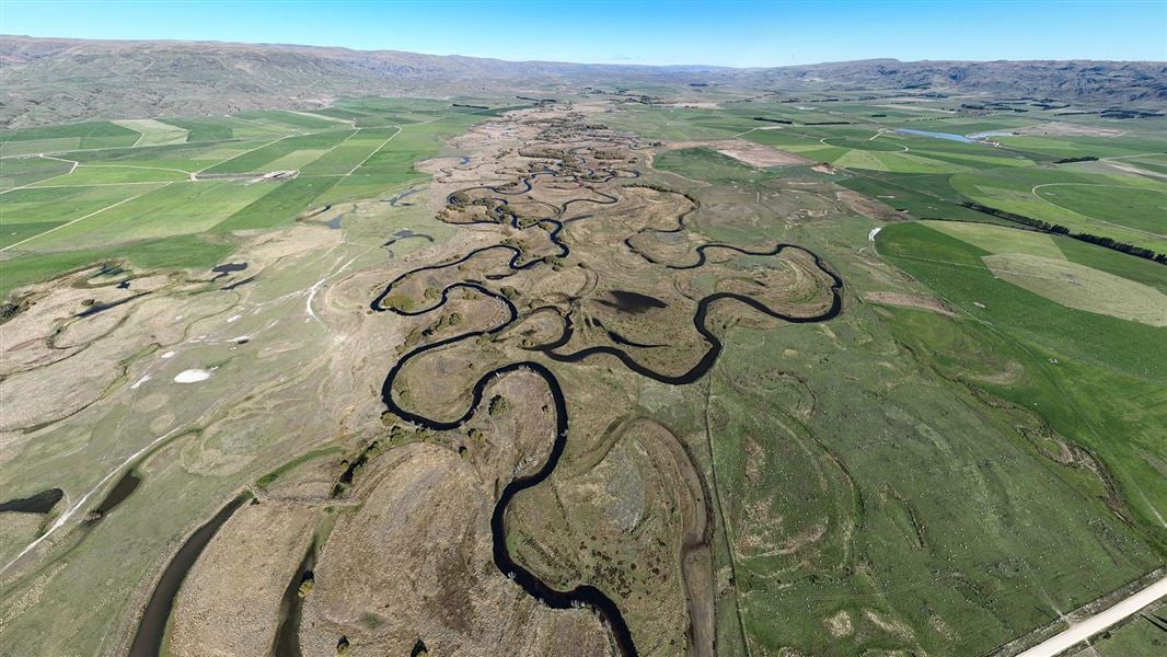
The top of the catchment is an area of tussock grassland in Te Papanui Conservation Park. The river flows over a series of steep rapids (known as Taiari Falls) before twisting and winding through the Styx basin scroll plains. Scroll plains are a rare feature of freshwater systems where a stretch of river meanders across a flat, wide area and creates a mosaic of oxbow lakes and channels.
The river then enters the Paerau gorge and flows into another network of scroll plains in the Māniatoto Plains. After a further narrow gorge, it enters an area that was once Tunaheketaka/Taiari Lake but was drained in the late 1940s. This upper part of the river, which includes the pristine Te Papanui tussock lands and the only scroll plain ecosystem in Aotearoa, makes the Upper Taiari Wetlands Complex one of New Zealand’s most significant wetland areas.
Strath Taiari and Taiari Plains
An almost 180-degree turn southwards marks a major change in the river. It flows along the eastern margin of the Rock and Pillar Range through the Strath Taiari Plain. Here, the river is characterised by deep gorges and is often inaccessible. Deep Stream, Lee Stream and other waterways join the Taiari along this stretch before it passes Outram and flows into the Taiari Plain.
There is a large wetland complex on the Taiari Plains where the river drains the Waihola-Waipōuri Wetlands. At this point in the past the river would have joined waters from Waihoropuka, which included Lake Tatawai, Potaka and Marama Te Taha. However, these wetlands were drained by early European settlers. The river finally passes through the Taiari Gorge before it flows into the Pacific Ocean at Taiari Mouth.
Trout-free waterways
The headwaters of the Taiari River are above the steep cascades of Taiari Falls. The falls provide a natural barrier that prevent trout from entering the upper 25 km of river and tributaries. This trout-free area provides extensive habitat for the Nationally Vulnerable native fish, Taieri flathead galaxias.
Scroll plains
The Styx basin and Māniatoto Plains contain the only scroll plains in Aotearoa. These wetlands are significant internationally and one of the world’s largest remaining examples of this type of ecosystem. The scroll plains provide important habitat for tuna (eels) and native birds. Other benefits include buffering high and low river flows.
Ephemeral wetlands
Ephemeral wetlands form in areas without an outlet on the surface and are not wet all year round. There are many ephemeral wetlands among the tributaries of the river in the Strath Taiari valley. One is Sutton Lake, New Zealand’s only inland salt lake, which is located in the rain shadow of the Rock and Pillar Range. The Taiari catchment contains more saline ecosystems than any other catchment in Aotearoa.
The ephemeral wetlands are associated with many rare and threatened plant and animal communities. These species have evolved special features to thrive in the unique environments they inhabit.
Te Nohoaka o Tukiauau/Sinclair Wetlands
Te Nohoaka o Tukiauau/Sinclair Wetlands south of Dunedin contain river channels, pools, swamps and forested islands. The wetlands provide habitat for native plants, fish and birds and are valued as a wāhi taoka for mahika kai (food gathering), conservation, recreation and education.
The wetlands were returned to Ngāi Tahu in 1998. They are managed by Te Nohoaka o Tukiauau/Sinclair Wetlands Trust, which carries out weed control and replanting work. The goal is to protect, restore and promote the spiritual, physical, ecological and cultural values of the land and water, while allowing natural resources to be harvested.
Wetland complexes
The Lake Waipōuri/Waihora complex would have covered much of the Taiari Plains before large-scale drainage occurred in the 1850s. Despite the dramatic losses in the area of wetland, the remaining ecosystem provides habitat for 131 species of native plants and at least 46 species of birds.
Te Nohoaka o Tukiauau/Sinclair Wetlands is owned by Te Rūnanga o Ngāi Tahu and managed by Te Nohoaka o Tukiauau/Sinclair Wetlands Trust as an important mahika kai and wāhi taoka (culturally significant) site.
Threatened species in the catchment
The catchment contains important populations of threatened plants. Its unique landscapes provide habitat for 81 At Risk and Threatened species. Plants with a threat status of Nationally Critical include: Ceratocephala pungens; Crassula peduncularis; Lagenophora montana, Papataniwha; Lepidium juvencum, scurvy grass; Lepidium kirkii, salt pan cress; Lepidium sisymbriodes; Lepidium solandri, Maniototo peppercress; Puccinellia raroflorens, saltgrass; Simplicia laxa; Triglochin palustre, marsh arrow grass.
There are 20 species of native fish in the catchment, many of which are found nowhere else. 12 species are classified as At Risk or Threatened. Fish with a threat status of Nationally Endangered or Nationally Vulnerable include: Eldon’s galaxias, Central Otago roundhead galaxias, dusky galaxias, Taieri flathead galaxias, lamprey, kanakana.
It contains important habitat for more than 70 species of birds. Many of these are waterbirds associated with the many wetlands. Birds in the catchment with a threat status of Nationally Critical and Nationally Vulnerable include: Australasian bittern/matuku-hūrepo, black stilt, white-faced heron, black-billed gull, Australasian crested grebe, banded dotterel, black-fronted tern.
Many different species of lizard live in the Taiari catchment. 10 species are found here and nine of these are rare or threatened by habitat modification, fire and predation. The lizard species include: Burgan skink, Otago skink, grand skink, green skink, cryptic skink, Woodworthia Otago/Southland large, jewelled gecko, Oteake skink and Oligosoma maccanni (McCann’s skink) Not Threatened.
Contact
If you have any questions or want to get involved, email us.
Email: info@doc.govt.nz
![]()
About Ngā Awa river restoration
Ngā Awa is a programme working collaboratively in priority catchments to restore freshwater biodiversity.