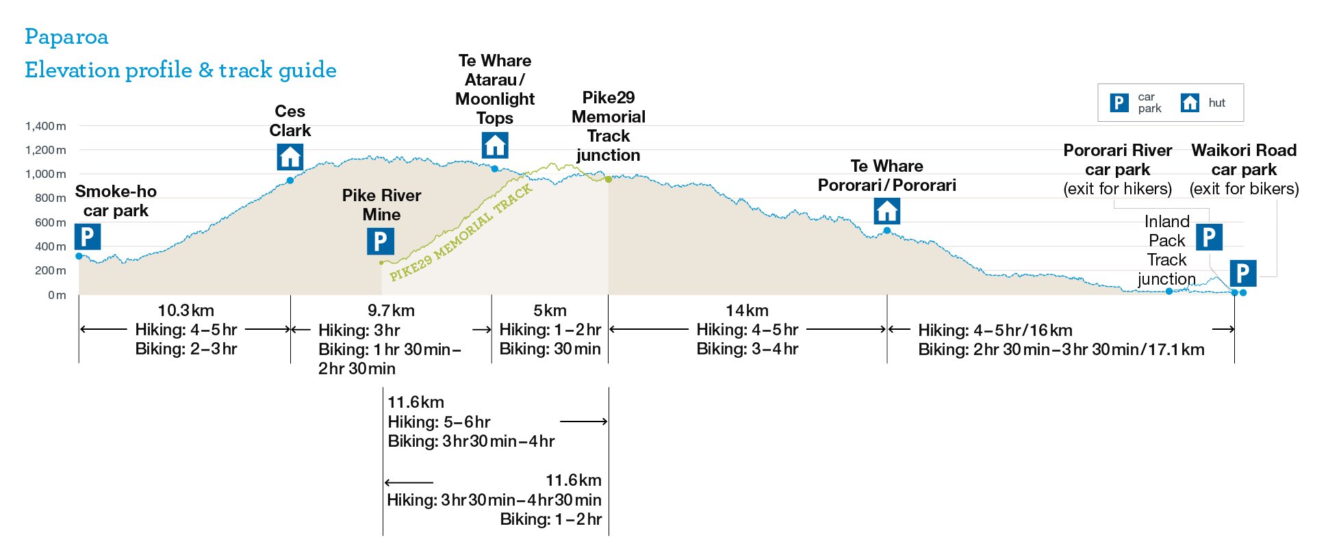
55 km one way
Image gallery
Video
Brochures
Time: 3 days walking, 2 days mountain biking (no e-bikes)
Distance: 55 km walking, 56. 2 km mountain biking (no-e-bikes)
Highlights
- Explore the spectacular Pororari River Gorge with dramatic limestone cliffs, beech forest and glades of subtropical nīkau palms.
- Sit back and enjoy in incredible sunsets over the Tasman Sea from the Moonlight Tops Hut.
- Follow in the footsteps of gold miners on the historic Croesus Track.
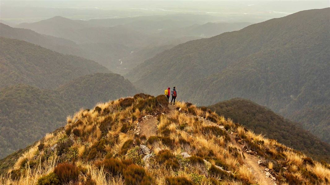
- Enjoy the stunning views. You’ll spot the Lone Hand rock formation on the way to Pororari Hut.
Places to stay
There are three Great Walk huts on the Paparoa Track: Ces Clark Hut, Moonlight Tops Hut and Pororari Hut. Huts have bunks, mattresses, heating, gas cooktops, toilets, and a water supply. A DOC ranger may be present. The huts do not provide food, cooking utensils or showers.
Backcountry Hut Passes can be used at Ces Clark Hut but not at Moonlight Tops or Pororari Huts.
There are no campsites on the track.
You'll need accommodation the night before your walk - camping at Smoke-ho car park is not permitted.
Fees are charged per person, per night to stay in huts on the Paparoa Track. There are no fees to complete a day walk/ride on the track or for entry into Paparoa National Park.
All three huts must be booked in advance. If you don’t have a valid booking for your stay, you may be charged a penalty, or turned away if the hut is full.
Walking options
- For a 1 or 2 night trip to Pororari Hut, see Paparoa Track: Pororari Hut Track.
- For a 2 night trip, stay at Moonlight Tops and Pororari Huts. It's not feasible to stay at Ces Clark Hut and Pororari Hut – it's 28.8 km and a 10 hr walk between these two huts.
- For a 3 night trip, stay at Ces Clark, Moonlight Tops and Pororari Huts.
- The Pike29 Memorial Track can be used along side the Paparoa Track for a range of both day and overnight options.
Track description
Smoke-ho car park to Ces Clark Hut
Time: 4–5 hr
Distance: 10.3 km
This part of the track is much rougher than the rest of the Paparoa Track because of its historic nature.
For the first hour of the track, you’ll pass through mixed podocarp and beech forest and cross a wire suspension bridge over the Smoke-ho Creek. The track then zig-zags up the dividing ridge between Blackball Creek and Roaring Meg catchments for the next hour until you reach the turn-off to the Battery Track.
The track then climbs more steeply into subalpine forest leading towards Ces Clark Hut. You’ll pass the historic Croesus Top Hut just before reaching Ces Clark Hut. Croesus Top Hut is kept for historic purposes – you cannot stay at Croesus Top Hut. However, in an emergency, you can use it for shelter.
Ces Clark Hut is on the edge of the bushline, set among low alpine scrub and with spectacular views. On a fine day you will be rewarded with views of Lake Brunner, the main divide, and down to Aoraki Mount Cook.
A night at Ces Clark Hut is a great option for those wanting a couple of shorter days or those looking for an easier 4 day hike.
Ces Clark Hut to Moonlight Tops Hut
Time: 3 hr
Distance: 9.7 km
Beyond Ces Clark Hut you pass through alpine scrub and tussock with expansive views of Grey River/Māwheranui and Tasman Sea.
The track follows the ridge of the main Paparoa Range through open alpine vegetation above the Roaring Meg and Moonlight Creek catchments, with views of Aoraki/Mt Cook on a clear day.
Moonlight Tops Hut has panoramic views across the Punakaiki River headwaters around to the escarpment, Pike Stream and Paparoa National Park.
Side trip: Croesus Knob
Time: 1 hr 10 min return
The turn-off to Croesus Knob is a 30-minute walk beyond Ces Clark Hut. From the main Paparoa Track, a rough route climbs to the top of Croesus Knob (1204 m), where there are spectacular views down to Aoraki Mount Cook and out to Tasman Sea.
This route is not suitable for mountain bikes and is not maintained to the same standard as the main Paparoa Track.
Moonlight Tops Hut to Pororari Hut
Time: 5–7 hr
Distance: 19.1 km
Along this section of track you will meet the junction of the Pike ridge with the main Paparoa Range, where the Pike29 Memorial Track and the Pike River Mine site begins.
Beyond the junction, the Paparoa Track winds along the top of the escarpment, with steep cliffs and stunning views down to the Pike Stream and out towards the coast.
There is an emergency shelter on the northern end of the escarpment. About half-way to Pororari Hut, you descend from the escarpment through ancient podocarp forest. The track then follows the ridge above Tindale Creek to Pororari Hut. Keep an eye out for the Lone Hand, a gnarled outcrop of bedrock on the north side of the Pororari River.
Pororari Hut to Pororari River car park or Waikori Road car park
Time: 4–5 hr
Distance: 16 km to Pororari River car park, 17.1 km to Waikori Road carpark
The track descends into the upper Pororari River valley and follows the river. In some places it follows an old track which was built c1912–1914 to establish a settlement in the valley. The track sidles along a spectacular gorge and descends through beech forest interspersed with northern rātā.
The Paparoa Track then passes the junction to the Cave Creek Memorial/Inland Pack Track. This track is dedicated to the memory of 13 students and a DOC officer. Their lives where lost when a viewing platform at Cave Creek collapsed on 28 April 1995.
In another 300 m the Paparoa Track diverges at a junction. Walkers can exit out to the Pororari River car park. Mountain bikers must exit out the Punakaiki River Valley to Waikori Road car park.
Understand if you are ready for the Paparoa Track
Watch the NZ Mountain Safety Council’s walk-through video which takes you through how to prepare for this track. Including facilities, key decision points, hazards and typical conditions for the area.
Mountain biking
Smoke-ho car park to Ces Clark Hut
Time: 2–3 hr
Distance: 10.3 km
Ces Clark Hut to Moonlight Tops Hut
Time: 1 hr 30 min – 2 hr 30 min
Distance: 9.7 km
Moonlight Tops Hut to Pororari Hut
Time: 4–5 hr
Distance: 19.1 km
Pororari Hut to Waikori Road car park
Time: 2 hr 30 min – 3 hr 30 min
Distance: 17. 1 km
Smoke-ho car park to Pike29 Memorial car park
Time: 6 hr 30 min – 9hr 30 min
Distance: 37 km
The Paparoa and Pike29 Memorial tracks are tough rides and should not be underestimated. To ride safely you need to be fit, experienced and well prepared with good equipment.
The Paparoa Track is a well-formed track with numerous swing and suspension bridges. The track is Advanced: Grade 4 with a mixture of long, steep climbs, narrow track, poor traction and obstacles that are difficult to avoid or jump over.
It's a particularly tough ride to Ces Clark Hut. The track is generally exposed at the outside edge. Most riders will find some sections easier to walk.
Plan to spend one night on the track.
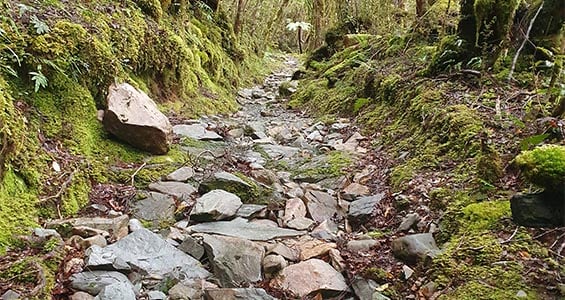
Rough section of the track up to Ces Clark Hut
Image: Ben Hodgson | DOC
Rules
- E-bikes are not allowed. E-bikes are prohibited under the Paparoa National Park Management Plan.
- Riding at night is not allowed, to protect nocturnal species found on the track.
This is a shared-use track. Follow the mountain bikers code: respect others, respect the rules, respect the track.
Ces Clark Hut fees
Prices are per person, per night. NZ rates are for New Zealand visitors and INT rates are for international visitors.
|
Date range |
Adult NZ |
Adult INT |
Child NZ |
Child INT |
Infant NZ |
|---|---|---|---|---|---|
|
1 October – 30 April |
$50 |
$76 |
$25 |
$38 |
Free |
|
1 May – 30 September |
$50 |
$50 |
$25 |
$25 |
Free |
Moonlight Tops Hut fees
Prices are per person, per night. NZ rates are for New Zealand visitors and INT rates are for international visitors.
|
Date range |
Adult NZ |
Adult INT |
Child NZ |
Child INT |
Infant NZ |
|---|---|---|---|---|---|
|
1 October – 30 April |
$78 |
$117 |
$39 |
$59 |
Free |
|
1 May – 30 June |
$61 |
$61 |
$30 |
$30 |
Free |
|
1 July – 31 August |
$50 |
$50 |
$25 |
$25 |
Free |
|
1 – 30 September |
$61 |
$61 |
$30 |
$30 |
Free |
Pororari Hut fees
Prices are per person, per night. NZ rates are for New Zealand visitors and INT rates are for international visitors.
|
Date range |
Adult NZ |
Adult INT |
Child NZ |
Child INT |
Infant NZ |
|---|---|---|---|---|---|
|
1 October – 30 April |
$61 |
$92 |
$31 |
$46 |
Free |
|
1 May – 30 September |
$50 |
$50 |
$25 |
$25 |
Free |
Proof of eligibility is required for the New Zealand rate.
Backcountry Hut Passes can be used as payment for Ces Clark Hut, however you'll need to book online, then claim a refund. To claim a refund, email paparoavc@doc.govt.nz with your booking reference and a scanned copy of your Backcountry Hut Pass.
Bookings
All three huts must be booked in advance. If you don’t have a valid booking for your stay, you may be charged a penalty, or turned away if the hut is full.
The nearest towns are Blackball, Greymouth and Punakaiki.
The track can be accessed by road at:
- Smoke-ho car park at the end of Blackball Road, 8 km north of Blackball.
- Pororari River Track carpark on SH 6, 1.2 km north of Pancake Rocks at Punakaiki
- Waikori Road carpark on SH 6, 2.4 km south of Pancake Rocks at Punakaiki
Transport
Several operators provide shuttle services to and from Paparoa Track.
Find transport around the coast (West Coast Tourism).
We recommend leaving your car at your accommodation – Smoke-ho car park is small and for day use only.
Be prepared for all conditions
Weather in Paparoa National Park is changeable with annual rainfall averaging around 6,000 mm (235 inches). Heavy rain, snow, ice, fog and strong winds are possible at all times of the year, especially on the exposed sections of the track.
You must be well equipped and prepared for all weather conditions and carry warm and waterproof clothing. If the weather becomes severe, stay put in a hut or turn back until conditions improve.
If you are hiking or biking the track in winter, check for snow and ice conditions before you leave and allow extra time. If in doubt, consider changing your trip to another day.
Weather forecast
Paparoa National Park weather forecast – NIWA website
Heavy rainfall damage
Sections of the Paparoa Track may be scoured or rutted due to heavy rainfall events. Bikers should take care as the damage can affect ride line and stability in some sections.
Landslides and rock falls
Be aware that landslides and rock falls can occur on the Paparoa Track, particularly during and after heavy rain. These can occur without warning. Follow instructions on warning signage and do not linger in identified rock fall areas.
Flooding and wind events
Some sections of track in the Pororari Valley may become impassable during times of very heavy rainfall. There is also a risk of landslides. There is danger of treefall in extreme wind events. Do not attempt to travel between Pororari Hut and the car parks in Punakaiki if these conditions occur. Take shelter in Pororari Hut and wait until conditions improve.
Be prepared for difficult riding sections
The section between Smoke-ho car park and Ces Clark Hut is a tough mountain bike ride as it's rough and narrow in places. Make sure you have the skills, fitness and time to tackle it.
Stay on the marked tracks
The track is well marked but if you become lost you should stop, find shelter and stay calm. Put on extra clothing to keep warm and assist rescuers should you hear them searching for you.
There is no cellphone coverage on most of the Paparoa Track.
Thieves targeting cars at car parks
There have been reports of cars being broken into and disabled at the Smoko, Waikori Road and Pororari River car parks.
- Don't leave valuables in your vehicle.
- Consider using more public parking sites – ask at the Punakaiki Visitor Centre for alternative options.
- Report any suspicious activity to police on +64 4 910 5105.
Watch out for Ongaonga (tree nettle)
New Zealand’s native tree nettle, Ongaonga, may be seen along the Paparoa Track in the Pororari Valley. It's sting is painful - don't touch its leaves.
Personal equipment
- Backpack – 40–60 litre size for multi-day hiking
- Waterproof/plastic pack liner
- Sleeping bag – 3–4 season
- First aid kit including blister treatment materials - see Mountain Safety Council first aid advice
- Survival kit including survival blanket, whistle, paper, pencil, high energy snack food
- Safety equipment relevant to the track and time of year, for example, map, compass
- Torch/flashlight and spare batteries
- Rubbish bag
- Booking confirmation and ID
- Earplugs for communal bunkrooms
- An emergency shelter, for if you are trapped by flooded rivers or bad weather
- A distress beacon
Cooking and food equipment
- Drink bottle – 1–2 litre capacity
- Eating and cooking utensils – knife, fork, spoon, plate, cup, pot/pan/billy, cleaning kit, tea towel. Check individual huts for what cooking facilities and lighting are provided.
- Matches or lighter in waterproof container
Toiletries
- Toiletries, including insect repellent, sunscreen, and personal medication, for example, antihistamine for allergy to wasp stings
- Use a toilet when you see one and be prepared with a backup toilet option
- Some of our Great Walk huts have sanitary bins but do come prepared if there isn't one. Find out more about Menstruation in the backcountry.
Clothing
- For multi-day walking you'll need at least one set of clothes to walk in and another dry set to change into at night.
- Tramping/hiking boots or firm footwear – should be comfortable and well broken in
- Socks – wool or polypropylene
- Shorts – quick dry material
- Shirt – wool or polypropylene
- Under layers, top and bottom – wool or polypropylene
- Mid-layers – wool or polar fleece
- Raincoat – waterproof, windproof with hood
- Overtrousers – wind and waterproof
- Warm hat and gloves
- Sunhat and sunglasses
- Extra socks, underwear, shirt/lightweight jersey
- Warm clothing to sleep in - hut bunkrooms don't have heating and can be cold
Optional
- Gaiters
- Lightweight shoes for inside the huts
Food
You cannot buy food on the track. Carry all the meals and snacks you will need, plus some spare, and a water bottle. We recommend food that is lightweight, fast cooking and high in energy value.
We do not provide emergency food in huts. You will need to carry emergency food supplies in case you are delayed by weather.
Store your food in a rodent-proof container or bag.
The Ngāti Waewae hapū (sub-tribe) of Ngāi Tahu are the kaitiaki of Paparoa National Park, guardians of the area’s native species and ecosystems. This kaitiaki responsibility is passed down the generations and draws on mātauranga (traditional knowledge) to care for the land, rivers and species.
In the 1860s, the discovery of gold on the West Coast sparked a gold rush and a sudden influx of European settlement. Between 1881 and 1899, the Croesus Track was constructed to allow better access to mines in upper Blackball Creek. The first part of the Paparoa Track follows this route. You can see the remnants of the gold-mining days by taking a side trip to Garden Gully.
The section of track between Pororari Hut and Punakaiki also follows historical routes.
The stretch between Waikori Road car park and the Pororari River follows the 1867 Inland Pack Track, once one of the main access routes between Greymouth and Westport. The track up the Pororari River was originally built to open up the area for farming. Few farms were formed and the route languished, but it was revitalised in the 1950s for a short-lived uranium-mining venture.
On 19 November 2010, 29 men perished in an underground explosion at the Pike River Mine. Created in partnership with the families of those 29 men, the Department of Conservation and Ngāti Waewae, the Paparoa Track is a memorial to the men and a thank you to New Zealanders for their support of the Pike River families.
Nature's in trouble
Thousands of New Zealand’s native species are heading towards extinction. Once they’re gone, they’re gone for good. Nature needs your help.
Stay safe in the outdoors
- Choose the right trip for you. Learn about the route and make sure you have the skills for it.
- Understand the weather. Check weather forecasts.
- Pack warm clothes and extra food. Check gear lists.
- Share your plans and take ways to get help. Leave your intentions with a trusted contact and take a distress beacon.
- Take care of yourself and each other.
Paparoa National Park Visitor Centre
| Phone: | +64 3 731 1895 |
| Email: | paparoavc@doc.govt.nz |
| Address: | 4294 Coast Road Punakaiki RD 1 Runanga 7873 |
| Hours: | Visitor centre hours and services |