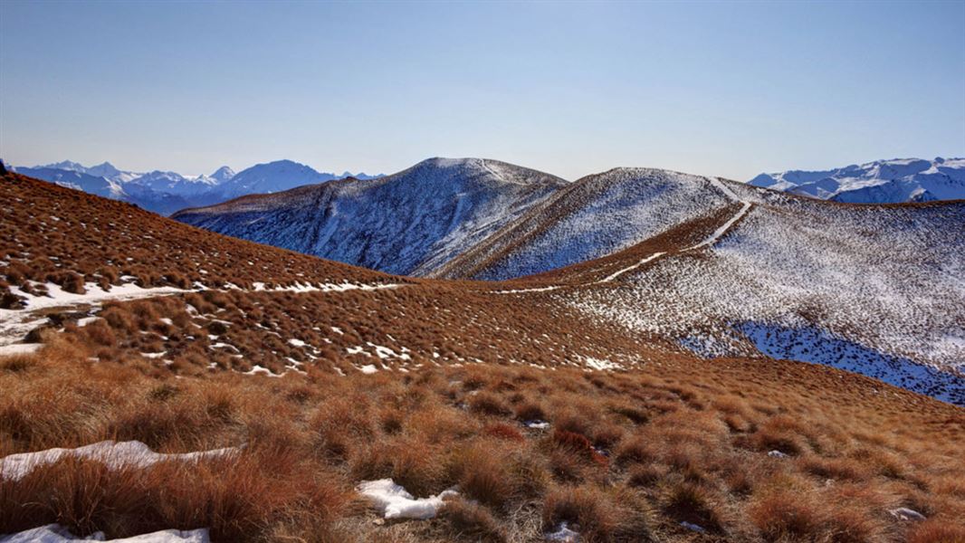
The track overlooks Lake Wānaka and Lake Hāwea, with great views of the Southern Alps/Kā Tiritiri o te Moana.
30 km return via same track
November to December – track closed annually for fawning between 20 November and 20 December.
March to May – Safari hunting takes place on Glen Dene Station. Be alert and stay visible, especially during the March to May roar hunting season.
Trampers will need to be fit to walk this steep track. It is well-marked – make sure you stick to the established trail as it is on private land.
From the car park, cross SH6 to the start of the track. Follow the track through the forest and across some farmland, until it joins a 4WD track. From here it is a steep rocky ascent that switchbacks up to a skyline ridge. Along the track, you won’t be able to see the summit until you are almost at the ridge; don’t be fooled by the false summits on the approach.
It is a steep and lengthy climb as you gain 1000 m over 8 km. Make sure you have sturdy hiking boots and plenty of water as there are no water sources along the track.
On reaching the ridge, a sign points to Isthmus Peak Track on the right and Glen Dene Ridge Track on the left.
Glen Dene Ridge Track along the tops traverses a number of unnamed peaks. It takes you into the Matatiaho Conservation Area.
There is no public access beyond the conservation area. Return to the Isthmus Peak Track car park by the same route.
You can mountain bike this track but on many sections you will have to dismount and push your bike.
Isthmus Peak Track car park is off SH6, north of Lake Hāwea township and 30 minutes drive from Wanaka.
Take care parking and crossing the road – this is a busy carpark beside the highway.
Your safety is your responsibility. Stay safe in the outdoors and follow the five essential steps of the Land Safety Code.
Adverse weather
The weather can change rapidly in New Zealand. Hypothermia is a real risk even in summer. Be prepared by having warm, waterproof, windproof clothing and the appropriate footwear. Whiteout conditions caused by snow or low cloud may be present. Check the Mount Aspiring National Park weather forecast – NIWA website.
Be avalanche alert
This area has terrain that can produce avalanches that cross the track, usually from May into November. View avalanche information and the terrain rating for this track.
Private property and permissions
This track crosses private land. There is no camping until the conservation area boundary.
Respect the landowner's livestock and property:
- stay on the marked track until you reach the conservation land
- leave gates as you find them
- use stiles where provided
- keep your distance from livestock.
There is a safari hunting operation on this station, give way to game animals, especially during the March to May roar.
Firearms are not permitted on these tracks.
Stay safe in the outdoors
- Choose the right trip for you. Learn about the route and make sure you have the skills for it.
- Understand the weather. Check weather forecasts.
- Pack warm clothes and extra food. Check gear lists.
- Share your plans and take ways to get help. Leave your intentions with a trusted contact and take a distress beacon.
- Take care of yourself and each other.
Wānaka Tititea/Mount Aspiring National Park
Visitor Centre
| Phone: | +64 27 269 6871 |
| Email: | wanakavc@doc.govt.nz |
| Address: | 1 Ballantyne Road Wānaka 9305 |
| Hours: | Visitor centre hours and services |