There is challenging avalanche terrain on Corner Peak Track.
Image gallery
This route should not be attempted in adverse weather. It is dangerously slippery when wet, icy or snowy. It is best suited to fit, experienced trampers. There is substantial elevation gain (significantly more than climbing Roys Peak).
The route begins from Tīmaru High River Track. Follow the track until you reach a junction, with a DOC sign marking the turnoff onto Corner Peak Route.
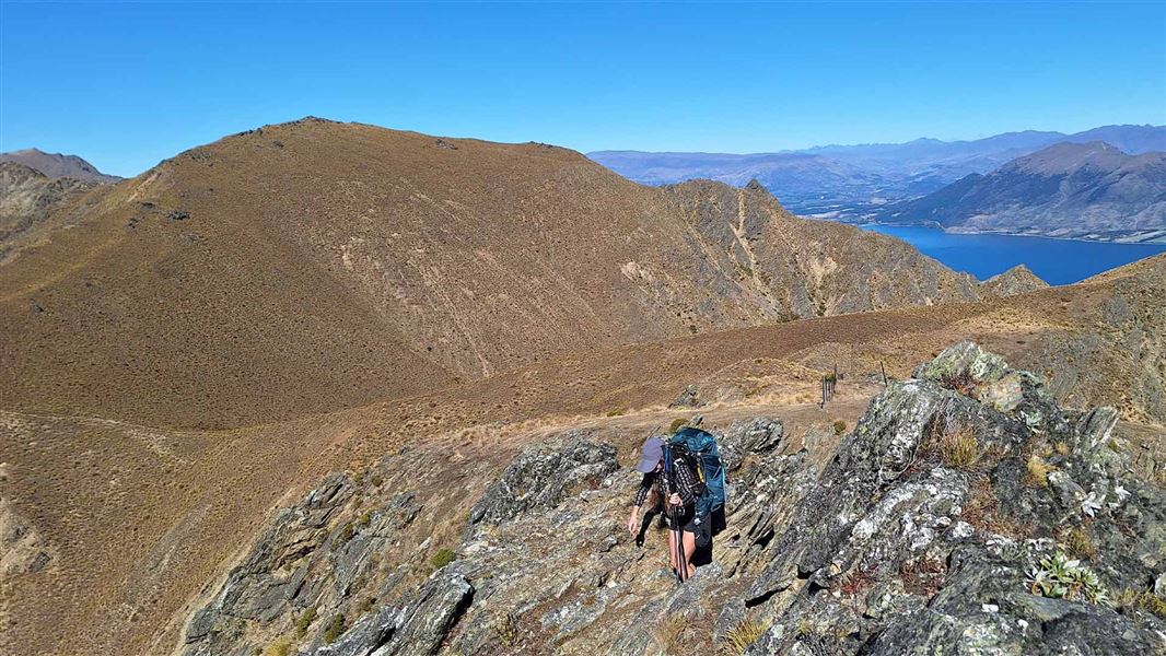
The route climbs very steeply up the side of the valley to the ridge. The route then follows the ridge to a high point at 1410 m.
Follow the marker poles to stay on the route. Navigation on this route can be challenging, particularly if there is low cloud, so watch the marker poles carefully. Carry a map and compass or GPS.
From this high point, the route continues to follow the ridge towards Corner Peak. Around halfway to the peak, the route ends at a stile at the boundary of Hawea Conservation Park. There is no marked route from here to Corner Peak, so if you wish to continue to the peak, you will need to navigate yourself through the rugged terrain to the summit at 1683 m.
Summer and winter conditions
The route can be extremely dry and hot in summer. There is no tree cover and no water sources on the route. It is important to have sun protection (sun hat, sunglasses, sun screen and clothing with good skin coverage) and to carry plenty of water.
The route is often icy/snowy in winter and there can be avalanche danger. It can be very windy at any time of year, especially on the ridgeline. Be aware of the weather and turn back if needed.
Be prepared
Be aware that there are sections on this track where a fall could cause a serious injury or even death. Take great care crossing steep sections.
Hikers need to be well prepared for this route. Always carry warm, waterproof clothing, spare food and plenty of water. Even in dry conditions, we recommend sturdy hiking boots with good grip. You may find poles useful. Day hikes packing list.
Follow the unsealed Timaru River Road from Lake Hāwea township for around 10 km.
Cross the road bridge over Tīmaru River and continue along Dingleburn Station Road for a short distance.
Follow Tīmaru High River Track until you reach the junction with Corner Peak Route.
Adverse weather
The weather can change rapidly in New Zealand. Hypothermia is a real risk even in summer. Be prepared by having warm, waterproof, windproof clothing and the appropriate footwear. Whiteout conditions caused by snow or low cloud may be present. Check the Mount Aspiring National Park weather forecast – NIWA website.
Be ready for hot, dry conditions in summer
This route can be very hot and dry in summer. There is no tree cover and no water sources along the route. Carry plenty of water and protect yourself from the sun.
Private property and permissions
This track crosses private land. There is no camping until the conservation area boundary.
Respect the landowner's livestock and property:
- stay on the marked track until you reach the conservation land
- leave gates as you find them
- use stiles where provided
- keep your distance from livestock.
There may be avalanche danger
Check the avalanche terrain in this area.
Avalanches usually occur from May to November in Wakatipu, Wānaka and Central Otago. There can also be avalanches outside this period, if there is still snow coverage.
Check the avalanche danger before you go on the New Zealand Avalanche Advisory.
If you are going into avalanche terrain, always:
- Have the relevant avalanche skills and training.
- Check the ATES rating and the New Zealand Avalanche Advisory.
- Go with a buddy. Both of you should carry and know how to use an avalanche transceiver, a snow shovel and a probe.
Stay safe in the outdoors
- Choose the right trip for you. Learn about the route and make sure you have the skills for it.
- Understand the weather. Check weather forecasts.
- Pack warm clothes and extra food. Check gear lists.
- Share your plans and take ways to get help. Leave your intentions with a trusted contact and take a distress beacon.
- Take care of yourself and each other.
Wānaka Tititea/Mount Aspiring National Park
Visitor Centre
| Phone: | +64 27 269 6871 |
| Email: | wanakavc@doc.govt.nz |
| Address: | 1 Ballantyne Road Wānaka 9305 |
| Hours: | Visitor centre hours and services |