In spring during lambing there is no exit via the Grandview Mountain Track. See Grandview Mountain Track for spring lambing closure.
Image gallery
This track is part of Te Araroa Trail.
This is a challenging backcountry tramping track suitable only for experienced trampers. The track is narrow in places with steep drop-offs, multiple unbridged river crossings, and limited marking.
We strongly recommend that you:
- only tramp this track if you're an experienced tramper
- stay on the marked DOC track and following orange markers at all times. Do not attempt to follow the riverbed or take unmarked routes – these are not managed, they are unmarked, and can be extremely dangerous
- avoid this track during or after heavy rain, or if heavy rain is forecast, due to increased risks from rising rivers and slippery terrain.
Birchwood Road to Top Tīmaru Hut
Time: 6 - 8 hr
Distance: 22 km
The track starts at the carpark on Birchwood Road. The initial part of this track is a public access easement through private farmland. It follows a fence that marks the boundary of the Ahuriri Conservation Park before crossing the Avon Burn and continuing along a farm track. Once past Tin Hut (private) the track climbs steadily as you enter Hāwea Conservation Park and continue to Mt Martha Saddle (1680 m). It's then 7 km downhill to Top Timaru Hut.
Care is required when descending; this track crosses scree slopes and is narrow and/or washed out in places.
Alternative route
Top Tīmaru Hut can also be reached via the Melina Ridge Track followed by the Mt Prospect Track. These are mostly unmarked old 4WD roads. Good navigational skills are required.
Top Tīmaru Hut to Timaru River track junction
Time: 6 - 7.5 hr
Distance: 12 km
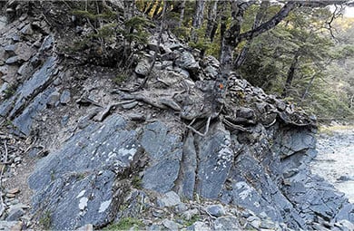
A steep rocky section of the track between Top Timaru Hut and Stodys Hut. Image: Matthew Gordon
This section of the track follows the Tīmaru River, weaving in and out of side gullies with multiple unbridged river crossings. The route is narrow in places, with steep sidles and some exposure. It is marked with orange triangles but may be difficult to follow in poor visibility. Trampers should take care navigating and allow extra time in challenging conditions.
The official DOC tramping track is the only managed and maintained track through this section. Stay on the marked DOC track and follow the orange triangle markers carefully.
Do not take unmarked routes along the Tīmaru River or through the riverbed. These routes are not managed, they are unmarked, and can be extremely dangerous, particularly during or after rainfall. There is no signage and conditions can change rapidly, creating hazards such as flooded gorge sections even when the river is low, and unstable footing and slippery surfaces.
Tīmaru River track junction to Stodys Hut
Time: 1hr 30 min - 2 hr
Distance: 2.2 km
From the track junction with Tīmaru River Track, the track climbs steeply out of the Tīmaru River valley, via a tree-lined ridge, to Stodys Hut.
Stodys Hut to Pakituhi Hut via Breast Hill
Time: 4 - 5 hr
Distance: 11.2 km
The track follows a farm track to the summit of Breast Hill. From the Breast Hill summit, the track follows the ridge to Pakituhi Hut.
Note: the northern end of Grandview Ridge tracks is an alternative track for this section, to bypass Breast Hill.
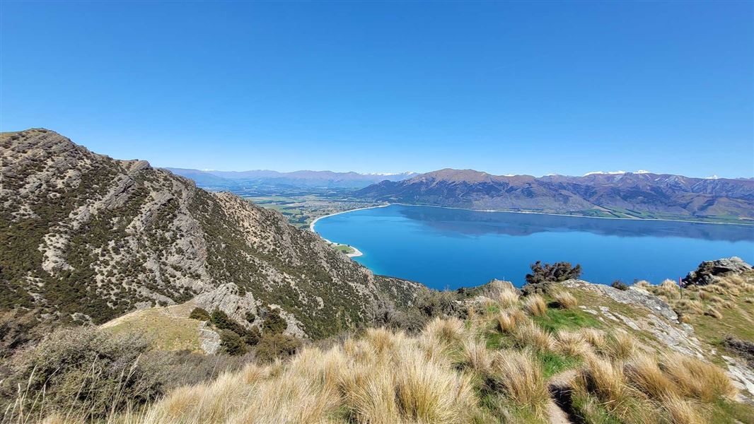
Pakituhi Hut to Lake Hāwea
Time: 2 - 3 hr to Tīmaru Creek Rd/Lake Hāwea
Distance: 4 km
The track ascends to the high point at 1300 m, then follows a prominent ridge as it descends towards Lake Hāwea. It then zig-zags down, ending at Tīmaru Creek Road, on the edge of Lake Hāwea, around 1km from Johns Creek township or approximately 6 km from Lake Hāwea township.
The upper section of this track is very narrow and exposed in places, with hikers needing to use their hands at times. In bad weather or high winds, the Grandview Mountain Track offers a good alternative route from Pakituhi Hut to Hāwea.
Note: the Grandview Mountain Track is closed for lambing from 5 October–16 November inclusive each year.
Alternative exits to the track
- Lower Tīmaru River Track
- Grandview Ridge Tracks and Grandview Mountain Track (Note: In spring during lambing there is no exit via the Grandview Mountain Track)
Mt Prospect Track (side trip)
Track category: Tramping track
Distance: 12 km return from Top Tīmaru Hut
Time: 5 - 6 hr
Follow the track 1 km downstream from Top Tīmaru Hut to reach the start of Mt Prospect Track.
The track steadily climbs for 5 km to reach Mt Prospect at 1770 m. For the last 1 km to Mt Prospect there is no track, so follow the fence line passing the junction with Mt Melina track on your left. Return the same way. This track is mostly an unmarked old 4WD road. Good navigational skills are required.
Be aware there are several stream crossings that can become uncrossable in heavy rain.
Turn off SH8 onto Birchwood Road, 18 km south of Omarama. Travel a further 11 km down Birchwood Road to the start of the track at Avon Burn carpark.
From the Lake Hawea side, the start of the track is located approximately 6 km from the Lake Hawea Township on the unsealed Tīmaru River Road, on the edge of Lake Hāwea. The carpark is located 320m north of the Breast Hill Track on the Lake side of the road.
This is a demanding track
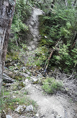
Track between Top Tīmaru Hut and Stodys Hut
Image: Matthew Gordon
Breast Hill Track is particularly demanding due to its exposed nature and physically demanding terrain. Make sure you have the skills and the right weather for walking the track.
- It is only suitable for experienced trampers.
- Stay on the marked DOC track and follow the orange triangle markers. Do not take unmarked, informal routes (e.g. down Tīmaru River) – they can be very dangerous, with flooded sections of gorge and unstable footing.
- Trampers should be fully self-reliant and prepared for delays due to weather or river levels.
- Carry a distress beacon. There is limited or no mobile coverage along most of the track.
- There is steep terrain with sections of narrow track that have drop-offs next to them.
Be aware of weather conditions
- Wintry conditions can occur at any time of the year, with the higher country subject to snow, especially during winter. Be prepared by having warm, windproof clothing and the appropriate footwear. There can be whiteout conditions.
- Avoid this track during or after heavy rain, or if heavy rain is forecast, due to increased river and slip hazards. There are many river crossings. Check the forecast
- Sections of the track have limited marking and in low cloud trampers will need navigational skills.
- It is often very hot and dry in summer. Carry plenty of water, as water sources are limited, and sun protection.
Pack well for this tramp
This is a backcountry tramp and you need to be well-equipped. Pack plenty of warm and waterproof clothing, navigational equipment (such as a map, compass and GPS), a distress beacon, an emergency shelter and at least an extra day’s food (in case you are delayed by weather or rivers). Water sources are limited, carry plenty of water.
Check our DOC multi-day tramping packing list
Lambs may be present, give them space
This track goes through a working farm. Lambs may be present late September – mid November. Move quietly and give ewes and lambs space, go around them if necessary. Never pick up lambs. Consider using alternative access from the Lower Timaru River Track during lambing season.
Avalanche risk
This area has terrain that can produce avalanches that cross the track, usually from May into November. View avalanche information.
Private property and permissions
This track crosses private land. There is no camping until the conservation area boundary.
Respect the landowner's livestock and property:
- stay on the marked track until you reach the conservation land
- leave gates as you find them
- use stiles where provided
- keep your distance from livestock.
Stay safe when crossing rivers
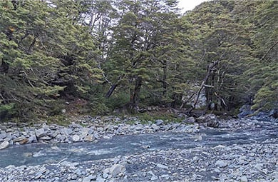
There are many unbridged crossings of Timaru River on this track.
Image: Matthew Gordon
If you plan to cross unbridged rivers, know how to cross safely and be prepared for if you cannot cross.
Do not cross if the river is flooded, you cannot find safe entry and exit points or are unsure it’s safe. Turn back or wait for the river to drop. If in doubt, stay out.
Stay safe in the outdoors
- Choose the right trip for you. Learn about the route and make sure you have the skills for it.
- Understand the weather. Check weather forecasts.
- Pack warm clothes and extra food. Check gear lists.
- Share your plans and take ways to get help. Leave your intentions with a trusted contact and take a distress beacon.
- Take care of yourself and each other.
Wānaka Tititea/Mount Aspiring National Park
Visitor Centre
| Phone: | +64 27 269 6871 |
| Email: | wanakavc@doc.govt.nz |
| Address: | 1 Ballantyne Road Wānaka 9305 |
| Hours: | Visitor centre hours and services |