Tongariro National Park is an active volcanic area. Eruptions can occur with little or no warning. The closer you are to the Park’s active volcanic vents, the higher the risk you are exposed to.
A network of volcanic monitoring equipment and warning systems mitigate risk but cannot guarantee your personal safety. You are responsible for deciding the level of risk that is acceptable to you and planning your visit accordingly.
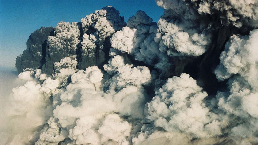
Image gallery
On this page:
- Current status of volcanoes
- What to do before you go
- How to stay safe in an eruption
- Ruapehu Summit Hazard Zone and reducing risk
- Tongariro Hazard Zone and reducing risk
Current status of volcanoes
Ruapehu volcano
Management stage: DOC Risk Management Stage A
GeoNet level: Volcanic Alert Level 1 - Minor Volcanic Unrest
DOC Risk Management Stage A is considered by DOC to be a normal level of volcanic unrest at Ruapehu during GeoNet Volcanic Alert Level 1.
We recommend:
- Do not camp or stay overnight within the area 1.5 km from the centre of Te Wai ā-moe/Crater Lake.
- Do not enter the area within 700 m from the centre of Te Wai ā-moe/Crater Lake.
Select camp sites on high ground away from the potential path of lahars. If you are in a valley and an eruption occurs, move immediately out of the valley to higher ground.
DOC advises that volcanic eruptions can occur at any time with little or no warning.
More advice on how to reduce risk at Stage A
Tongariro volcano
Management stage: DOC Risk Management Stage A
GeoNet level: Volcanic Alert Level 0 - No Volcanic Unrest
We have no additional guidance at this time.
Ngāuruhoe volcano
Management stage: DOC Risk Management Stage A
GeoNet level: Volcanic Alert Level 0 - No Volcanic Unrest
We have no additional guidance at this time.
What to do before you go
- Check the current status of the volcanoes in the park and follow the risk reduction advice at appropriate DOC Risk Management Stage (see above).
- Know where the volcanic hazards zones are.
- Check the webpages of DOC tracks you plan to use for any closures and additional safety advice.
- Know the eruption advice for Whakapapa Ski Area or Whakapapa Village if visiting these areas.
- Consider whether you're comfortable with the volcanic risk associated with your trip. If you are not comfortable, visit somewhere outside the Park's volcanic hazard zones.
How to stay safe in an eruption
- Move immediately away from the eruption site, staying out of valleys.
- If you’re in a valley, move sideways to higher ground (a ridge top) – a fast moving volcanic mud flow like a flash flood (a ‘lahar’) is possible.
- If you see flying rocks, or a steam and ash cloud coming towards you, take shelter behind a bank or ridge and cover your head with your pack.
- If you are in Whakapapa Ski Area or Village, follow the below instructions.
If an eruption is detected at Ruapehu, a siren and voice message warning will sound in areas at risk from lahars at Whakapapa Ski Area. It signals visitors to move out of lahar paths to higher ground on ridges.
If you hear WLAWS sirens (9,187K, WAV) and voice messages in Whakapapa ski area:
- Move immediately out of valleys – sideways to higher ground (a ridge top)
- Remain in a safe area on higher ground until advised by ski field staff to move.
- If you are in a building or car park – stay put.
- If you are in the Ruapehu Summit Hazard Zone, move down the mountain along ridges to the base area.
- If you see flying rocks, or a steam and ash cloud coming towards you, take shelter behind a bank or ridge and cover your head with your pack.
Eruption action plan for Mt Ruapehu club lodges.
Ski area maps
If a lahar is detected in the Whakapapanui Stream, a siren and voice message warns of a possible lahar approaching Whakapapa Village. It signals visitors to move out of at-risk areas to designated evacuation points.
If you hear VLAWS sirens (4,075K, WAV) and voice messages in Whakapapa village:
- Move immediately away from the Whakapapanui Stream to the eastern side of the Bruce Road. Buildings and facilities on the western side of the road – the Holiday Park, Hepi Terrace and the Tavern – are at risk from lahar.
- Assemble at the Chateau Tongariro.
- Stay at the Chateau Tongariro until advised by hotel or DOC staff to move.
The Ruapehu Eruption Detection System (REDS) detects eruptions from the active crater of Mt Ruapehu (Te Wai ā-moe/Crater Lake) using acoustic and seismic sensors. It’s the trigger for the Whakapapa Ski Area Lahar Alert and Warning System (WLAWS).
The Whakapapa Village Lahar Alert and Warning System (VLAWS) warns the public of lahar risk in Whakapapa Village. The system uses a lahar fence (tripwire) in Skippers Canyon to detect lahars travelling down the Whakapapanui Stream. The system is primed by REDS and will not activate without an eruption being detected.
How to reduce risk at Ruapehu
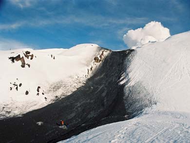
Lahar deposit on Ruapehu, 1996
Eruption hazards
The Summit Hazard Zone on Ruapehu is a 3 km radius around Te Wai ā-moe/Crater Lake, which fills the vent of Ruapehu.
Flying rocks, fast-moving clouds of steam and hot ash can occur during eruptions of Ruapehu. These are the most hazardous within the Summit Hazard Zone.
The main volcanic hazard on Ruapehu is lahar. Lahars are a fast-moving volcanic mud flow like a flash flood. They occur during eruptions when water in the lake is ejected and flows at speed down valleys as a flash flood – mixing with ash, rocks and snow on the way down.
There are multiple lahar paths through Whakapapa Ski Area, where a lahar warning system operates. Lahars can also occur when volcanic debris on the volcano’s slopes is remobilised during heavy rain.
Lahars can have impact beyond the Summit Hazard Zone – large events have travelled well beyond the slopes of the volcano.
Reducing risk at each Risk Management Stage on Ruapehu
At all activity levels, the closer you are to Te Wai ā-moe/Crater Lake and the longer you stay, the higher the risk you are exposed to. Eruptions can occur at any time, with little or no warning.
See the Current Status section for Tongariro National Park volcanoes’ present activity.
Click the DOC's Risk Management Stage and Volcanic Alert Level below to read our advice on how to reduce the risk.
GeoNet Volcanic Alert Level 1 is considered to be a normal level of volcanic unrest at Ruapehu. This is because the volcano is always in a state of minor volcanic unrest.
At DOC Risk Management Stage A, we recommend that you:
- do not enter the area 700 m from the centre of Te Wai ā-moe/Crater Lake.
- do not camp in the area 1.5 km from the lake’s centre.
- do not camp on the Summit Plateau or in valleys.
- select camp sites on high ground away from the potential path of lahars. If you’re in a valley and an eruption occurs, move immediately to higher ground.
Maps:
DOC Risk Management Stage B is considered by DOC to be a slightly elevated level of volcanic unrest at Ruapehu during GeoNet Volcanic Alert Level 1.
We recommend:
- do not enter the area 1.5 km from the centre of Te Wai ā-moe/Crater Lake.
- do not camp on the Summit Plateau or in valleys.
- select camp sites on high ground away from the potential path of lahars. If you are in a valley and an eruption occurs, move immediately to higher ground.
Maps
GeoNet Volcanic Alert Level 2 is considered to be moderate to heightened level of volcanic unrest at Ruapehu.
At this stage, the area 2 km from the centre of Te Wai ā-moe/Crater Lake is closed. Do not enter this area.
To reduce your risk of exposure to volcanic hazards:
- do not enter the 2 km Exclusion Zone.
- minimise the time you are in valleys and rivers that are known lahar paths.
- cross potential lahar paths quickly.
- minimise time you are in the 3 km Summit Hazard Zone.
- select camp sites on high ground away from the potential path of lahars. If you’re in a valley and an eruption occurs, move immediately to higher ground.
Maps
How to reduce risk at Tongariro
Tongariro and Ngāuruhoe are currently at GeoNet Volcanic Alert Level 0 and have no volcanic unrest. Due to the current lack of activity, there is no additional risk reduction advice for visitors at Tongariro.
The Tongariro Alpine Crossing and Tongariro Northern Circuit both pass through Tongariro's volcanic hazard zone. If GeoNet Volcanic Alert Level (VAL) increases at either the Tongariro and Ngāuruhoe volcanoes, there will be track or track section closures.
The Tongariro Hazard Zone is a 3 km radius from each of the three active vents of Mt Tongariro – Te Maari, Red Crater and Ngāuruhoe. Reduce your risk before you go by reviewing the:
- current status of volcanoes
- area covered by the hazard zone via the Tongariro Hazard Zone map (PDF, 1,763K)
- closure and safety alerts on track webpages:
How we manage risk at each volcanic alert level
We manage volcanic risk on the Tongariro Alpine Crossing and Tongariro Northern Circuit by identifying closure points based on the GeoNet Volcanic Alert Level (VAL) at the Tongariro and Ngāuruhoe volcanoes.
Tongariro and Ngāuruhoe typically sit at VAL 0 (no volcanic unrest). When the VAL increases to 1 (minor volcanic unrest) at either volcano, we close tracks and assess.
The length of this initial VAL 1 closure period is dictated by the data available, risk assessments and input from GNS and/or other subject matter experts. If DOC is confident that the probability of eruption is low, and the level of risk is tolerable, then the track is reopened.
At VAL 2 and above, the track is closed until the activity has deescalated to VAL 1 or VAL 0. Again, the assessment to reopen would involve risk assessments and expert input.
Eruption hazards
The three vents at Tongariro have all been active within the last 100 years. The most recent eruption occurred from Te Maari in 2012.
Flying rocks (ballistics) and fast-moving clouds of steam and hot ash are the main volcanic hazards on Tongariro.
Even when the tracks are open, some volcanic risk is present as eruptions can occur at any time. If you are uncomfortable with this risk, choose a different track outside of volcanic hazard zones.
Read more on how to stay safe in an eruption.
New Zealand Volcanic Alert Levels
The system evaluates the current level of volcanic unrest or eruption of the volcanoes in Tongariro National Park. The New Zealand Volcanic Alert Level is set by GeoNet, based on volcano monitoring data from the Park. There are six Volcanic Alert Levels, ranging from no volcanic unrest, through two levels of volcanic unrest, to three levels of volcanic eruption.
For more information and to see the current Volcanic Alert Levels for the volcanoes of Tongariro National Park, see Volcanic Alert Levels (GeoNet website)