In winter, snow may affect access to, and along, the tops to the hut.
The hut is located in a popular Haast Roar hunting area, so may be particularly busy throughout the Roar period, mid-March to mid-April.
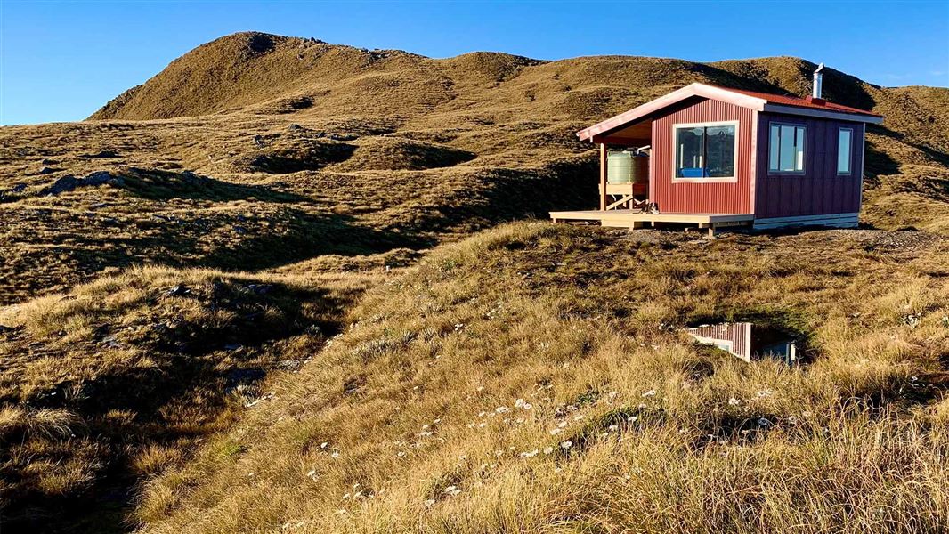
This hut is owned and maintained by the Backcountry Trust. It is available for the public to use.
You need to bring your own cooking tools such as a gas cooker.
Information about Mataketake Hut on Backcountry Trust website.
History
Mataketake Hut opened in February 2021. It was built by the Andy Dennis Trust, and is owned and maintained by the Backcountry Trust. Andy Dennis, a renowned New Zealand conservationist and author and a long-time member of Federated Mountain Clubs and Forest & Bird, died in 2016 leaving a bequest to build a new hut in the mountains of the South Island.
This hut site was chosen for its stunning surroundings, link with the historic pack track and plentiful birdlife.
Fees
Adult: $25 per night
Youth (11–17 years): $12.50 per night
Child/infant (10 years and under): free
Backcountry Hut Passes and Backcountry Hut Tickets cannot be used at this hut.
Bookings
Bookings for the 2026/27 season open at 12 noon on Tuesday 12 May 2026.
- If no availability shows online for your dates, the hut is fully booked.
- No spaces are kept for visitors arriving without a booking.
- Phone and in‑person bookings made at a visitor centre incur a $10 service fee.
- Same‑day bookings are available online until 8 pm if spaces remain.
Bookings are required all year.
Your hut booking is for any bunk bed, not for a specific bunk bed – select your bunk bed on arrival.
Mataketake Hut can be reached via Māori Saddle Route and Mica Mine Route. We recommend going up to the hut via the Māori Saddle Route. This will give you the best opportunity to judge the weather conditions on the tops and enable easy retreat if needed.
Tracks to this hut
-
Duration: 9 hrs one way from SH6 Difficulty: Expert -
Duration: 8 hr from SH6 Difficulty: Expert
Location
NZTopo50 map sheet: BY13
Grid/NZTM2000 coordinates: E1301412, N5141230
Travel to the hut along the Mica Mine Tops Route should only be attempted in clear weather – above the bush line, cloud can obscure the route making navigation difficult. If you are unsure about the conditions you should wait for better weather.
Only those with suitable backcountry route finding/navigation skills, safety equipment (including personal locator beacon) and warm, weatherproof clothing should attempt this route.
The lower sections of track crosses numerous small streams which flood quickly during rainfall. Trampers should wait until water levels have dropped before proceeding.
Awarua/Haast Visitor Centre
| Phone: | +64 27 303 4890 |
| Email: | haastvc@doc.govt.nz |
| Address: | Haast Junction Corner SH6 and Jackson Bay Road Haast 7886 |
| Hours: | Visitor centre hours and services |
Westland Tai Poutini National Park Visitor Centre
| Phone: | +64 3 752 0360 |
| Email: | westlandnpvc@doc.govt.nz |
| Address: | 69 Cron Street Franz Josef Glacier 7856 |
| Hours: | Visitor centre hours and services |