A section of the track crosses private property and dogs are not allowed there. This is marked by signs. Dogs are allowed on the rest of the track.
14 km one way
This track is part of Te Araroa Trail.
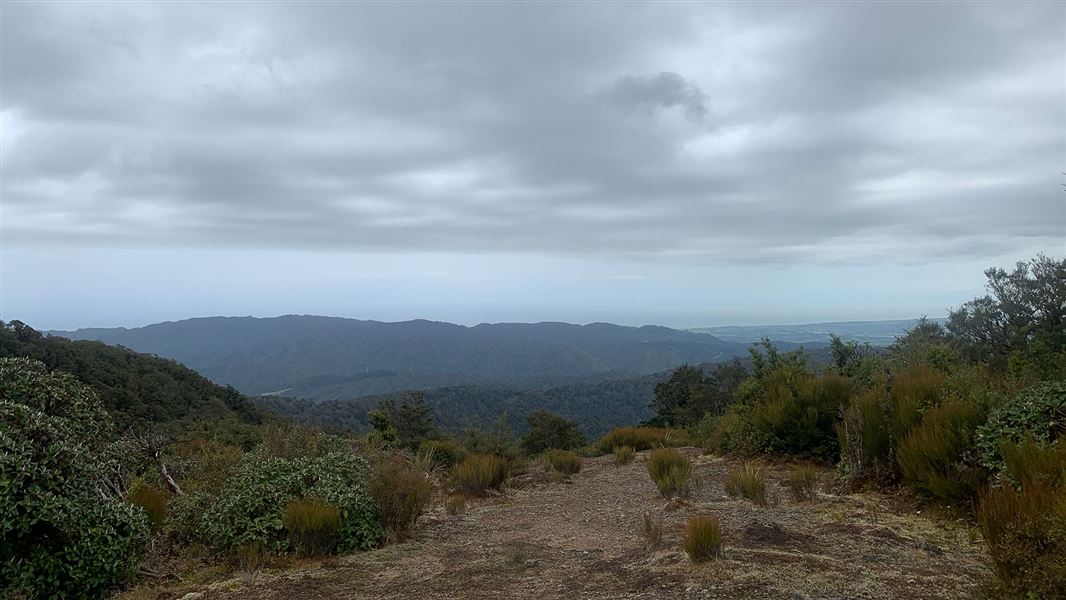
The first part of the track climbs steadily through mixed forest with grass clearings that provide sweeping views of Otaki Forks and the Tararua Range. The highest point at Pukeatua (812m) is a good place to lunch. The track then descends down a series of bush clad ridges, passing through private land and pine plantation before joining a four wheel drive track and exiting at South Mangaone Road Car Park opposite the Mangaone Walkway.
The area adjacent to the pine forest is private land covenanted with the Queen Elizabeth II National Trust to preserve native forest. Walkers are required to respect the protected area and stay on the marked track (blue poles).
Track details
The Pukeatua Track starts at the Fenceline Carpark at Otaki Forks, 2km from Parawai Hut. From the DOC information sign, follow the Fenceline Loop Track for 700m to a marked junction to Pukeatua Track. The track takes a sharp left uphill turn to a southwest ridge.
Continue uphill for about 3 hours with a hard right turn just prior to exiting the bush before Pukeatua (812m). The track skirts the scrubby tops on the eastern side to Pukeatua Summit. From the summit the track follows the south side of a westerly ridge to a saddle and then northwest down a ridge to a broad ridge and intersection. Turn right at the fork, following the markers down to a stream. Turn right at the stream and cross diagonally just above the junction and then left on to a four wheel drive track leading to a metalled road.
Exit left and walk down the road, crossing the pedestrian bridge to the South Mangaone Road Car Park and track end.
Note: The Gorge road to Otaki Forks is narrow and winding and not safe for walkers.
- Northern entrance/exit: Ōtaki Forks, Fenceline car park. Ōtaki Forks is 19 km inland from Ōtaki township – approximately 1 hr 30 min drive from Wellington or Palmerston North.
- Southern entrance/exit: Mangaone South Road. Mangaone South Road runs off Ngatiawa Road, 8 km south-east from Waikanae.
What to expect
This is a typical backcountry tramping track. It is rough and uneven, and you can expect mud in places and to be scrambling up and down tree roots.
There are small stream crossings and sections of 4WD track/road where there can be vehicles.
Pack well, including warm and waterproof clothing
Weather in the Tararua Forest Park can change rapidly. Cold and wet weather is common at any time of year. Always carry a waterproof raincoat and plenty of warm layers of clothing.
Pack a torch, plenty of drinking water and everything on the day hikes gear list.
Full list of what to take on a day walk.
Private Property
This track crosses private property. When crossing this area, keep to the track marked by orange triangles and blue poles. Dogs, firearms, fires and bikes are not allowed on this section of track.
Stay safe in the outdoors
- Choose the right trip for you. Learn about the route and make sure you have the skills for it.
- Understand the weather. Check weather forecasts.
- Pack warm clothes and extra food. Check gear lists.
- Share your plans and take ways to get help. Leave your intentions with a trusted contact and take a distress beacon.
- Take care of yourself and each other.
Wellington/Kapiti information
| Phone: | +64 3 546 9339 |
| Email: | nelsonvc@doc.govt.nz |
| About: | Whakatū/Nelson visitor services provide information for this area |