Fitness required: High
Gradient: Steep
11 km return via same track
Fires are not allowed at any time. See fire rules on conservation land.
In winter you will need to carry and be able to use alpine equipment such as avalanche equipment, ice axe and crampons. The track may change between very slippery and muddy.
Video
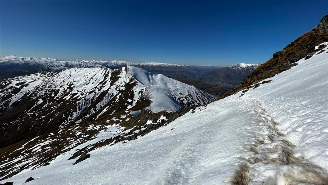
The Ben Lomond Track rewards trampers with spectacular panoramic views over Queenstown, Lake Whakatipu and the surrounding mountain ranges. These include Ka-kamu-a-Hakitekura/Cecil and Walter Peaks and Kawarau/Remarkables.
In fine weather, you may even spot Mounts Pikirakatahi/Earnslaw and Tititea/Aspiring in the distance.
The area between Rat Point and Arthurs Point (including Ben Lomond) above Queenstown has a year-round ban on outdoor fires.
Tiki Trail to Ben Lomond Summit
Time: 6-8 hr return
Distance: 14 km return
This track starts from the Skyline Gondola base on Brecon street.
The track begins among Douglas fir on the Tiki Trail behind the stone wall of the cemetery. At about 800 m altitude you leave the tree line behind to enter alpine tussocks and shrubs. Climb to the 1,326 m Ben Lomond Saddle.
Beyond the saddle is Ben Lomond Station where the track crosses private land and is unmaintained. From here, the terrain becomes steeper and rougher. The hardest part of the climb remains as you approach Ben Lomond's 1,748 m summit.
There are steep drop offs from the track on the way to the summit. The track here can be more treacherous if covered in snow and ice.
Note: The section from the saddle to the summit crosses private land. Respect the landowner’s rights and keep to the formed track to avoid stock disturbance and farm hazards.
Tiki Trail to Ben Lomond Saddle
Time: 5 hr return
Distance: 10 km return
You can follow the Tiki Trail to hike to Ben Lomond Saddle from Queenstown.
Skyline Gondola top complex to Ben Lomond Saddle
Time: 3-4 hr return
Distance: 7 km return
Enjoy a shorter tramp on the Ben Lomond Track by riding the Gondola to the Skyline complex and hiking to the Ben Lomond Saddle and back.
This is a good option for trampers who would like to take in the views while building the fitness and experience required to hike to the summit.
Understand if you are ready for the Ben Lomond Track
Watch the NZ Mountain Safety Council’s walk-through video which takes you through how to prepare for this track. Including facilities, key decision points, hazards and typical conditions for the area.
Located near central Queenstown, the four access points to this track are:
- the Tiki Trail, starting next to the Skyline Gondola base station at the top of Brecon Street (best option)
- the bottom of the Skyline Access Road on Lomond Crescent
- from One Mile Creek Track which starts at the Fernhill roundabout (navigation required)
- the Skyline Gondola - return or can pay for a one-way ticket downhill.
Ensure you leave enough daylight hours, but pack a headtorch just in case. In winter, you'll need alpine equipment.
What to expect
- A full day's hike with 1,438 m elevation gain. Remember, the peak is only the halfway point.
Fire hazard
The area between Rat Point and Arthurs Point (including Ben Lomond) above Queenstown has been designated a High Fire Risk Zone (Called the Queenstown Red Zone) as it is at risk from wildfire. There is a year-round ban on outdoor fires.
Further hazards
The weather changes rapidly in this region. Hypothermia is a real risk even in summer.
Numerous steep downhill mountain bike tracks intersect with the walking track. Due to the high speeds these are unsafe for walkers. Be careful to follow the signs and stay on walking tracks.
Animals have also formed tracks across the mountain. Ensure you follow the signs and orange markers to stay on the right track.
Amenities
- There are toilets at the top complex of the Skyline Gondola.
- There is now a toilet located 100 m before Ben Lomond saddle. Take your own supplies. No water, hand sanitiser or toilet paper is provided. Do not use the toilet as a rubbish bin. Carry your rubbish back off the track with you.
- Plan accordingly or bring a pocket toilet, available for purchase at Whakatipu-wai-Māori/Queenstown Visitor Centre.
What to take
Pack enough water for the day. There is no water past the Skyline Gondola complex.
Weather forecast
All drone use must be authorised by DOC
You must have a permit to fly a drone on public conservation land.
Visit our Drone use on conservation land page for more information.
Nature's in trouble
Thousands of New Zealand’s native species are heading towards extinction. Once they’re gone, they’re gone for good. Nature needs your help.
Stay safe in the outdoors
- Choose the right trip for you. Learn about the route and make sure you have the skills for it.
- Understand the weather. Check weather forecasts.
- Pack warm clothes and extra food. Check gear lists.
- Share your plans and take ways to get help. Leave your intentions with a trusted contact and take a distress beacon.
- Take care of yourself and each other.
Whakatipu-wai-Māori/Queenstown Visitor Centre
| Phone: | +64 3 442 7935 |
| Email: | queenstownvc@doc.govt.nz |
| Address: |
50 Stanley Street |
| Hours: | Visitor centre hours and services |