24 km return (from Camerons Flat) 30 km return (from Otago Boys' High Bridge)
The Kitchener Valley is prone to flooding in heavy rain and can be inaccessible.
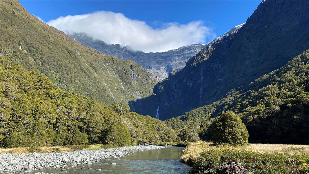
Image gallery
This is a challenging and technical track that needs backcountry hiking experience. Expect slips and sections of track that are rough, slippery, muddy and require scrambling. Allow plenty of time.
Camerons Flat to Junction Flat
Time: 3 hr
Distance: 9.5 km
Ford the Matukituki River at Camerons Flat. Walk upstream from the car park to find a suitable crossing point. If the river is high, drive 2.5 km further along the road towards Raspberry Creek and park by the Otago Boys' High Bridge at MacPherson Creek. Use the bridge to cross the West Matukituki and walk for an hour to join the East Matukituki track.
The track leads up the East Matukituki valley. The grassy river flats are leasehold farmland, do not disturb the stock.
After reaching and crossing the Glacier Burn the track undulates alongside the East Matukituki River until it reaches Junction Flat and the Kitchener River. Expect muddy sections and to be scrambling up and down tree roots and rocky sections. There are several major slips to cross.
Junction Flat to Aspiring Flats
Time: 1 hr
Distance: 2.55 km
This track follows the true right of the Kitchener River and climbs an old unstable slip which is narrow. Markers are known to move because of slips and care is required when crossing this section. The track passes through beech forest to the top of the gorge and ends at Aspiring Flats.
There are spectacular views of the Kitchener Cirque from Aspiring Flats.
Be vigilant for quicksand if crossing the silty flats. Take care choosing a camp spot in Aspiring Flats as the Kitchener Valley is prone to flooding.
Rock of Ages Biv
The Rock of Ages rock biv is a large leaning rock in the Kitchener Valley. It is a natural rock feature rather than a DOC managed campsite so there are no facilities, including no water supply and no toilet (Toileting tips for the backcountry).
The rock biv is 30 minutes further on from where the track reaches the flats. It is about 20 metres up into the bush, near the head of the flats. There is no marked track to the biv and it can be difficult to find, so be sure to take a tent as backup.
This track starts on the opposite side of the Matukituki River from Camerons Flat.
Camerons Flat is a one-hour drive from Wānaka on the Wānaka Mount Aspiring Road. The last 25 km is gravel. The turn-off to the Camerons Flat car park, on the right, is signposted. The Otago Boys' High Bridge at MacPherson Creek is a further 2.5 km along the road.
Mountain biking
Bikes are allowed from Camerons Flat to the boundary of Tititea/Mount Aspiring National Park, at the turn off for the Glacier Burn Track.
Weather and flooding
Unpredictable weather patterns mean that snow, strong winds and heavy rain can occur at any time of year.
Check the forecast and pack gear for all conditions.
The Kitchener Valley is prone to flooding in heavy rain and can become inaccessible. Carry spare food in case of delays.
Winter conditions
The track is likely to be extra slippery and muddy during winter, with occasional snow too. Take extra care.
Private property and permissions
This track crosses private land. There is no camping until the conservation area boundary.
Respect the landowner's livestock and property:
- stay on the marked track until you reach the conservation land
- leave gates as you find them
- use stiles where provided
- keep your distance from livestock.
Stay safe when crossing rivers and streams
If you plan to cross unbridged rivers or side streams, know how to cross safely and be prepared for if you cannot cross.
Do not cross if the river or stream is flooded, you cannot find safe entry and exit points or are unsure it’s safe. Turn back or wait for the river to drop. If in doubt, stay out.
NIWA river flow forecasts: View a video of national followed by regional river flows
Swing bridges
There's a limit to the number people allowed on the swing bridges at any one time – be prepared to wait at each end if numbers allowed have been reached.
Stay safe in the outdoors
- Choose the right trip for you. Learn about the route and make sure you have the skills for it.
- Understand the weather. Check weather forecasts.
- Pack warm clothes and extra food. Check gear lists.
- Share your plans and take ways to get help. Leave your intentions with a trusted contact and take a distress beacon.
- Take care of yourself and each other.
Wānaka Tititea/Mount Aspiring National Park
Visitor Centre
| Phone: | +64 3 443 7660 |
| WhatsApp: | +64 27 629 1012 |
| Email: | wanakavc@doc.govt.nz |
| Hours: | Visitor centre hours and services |