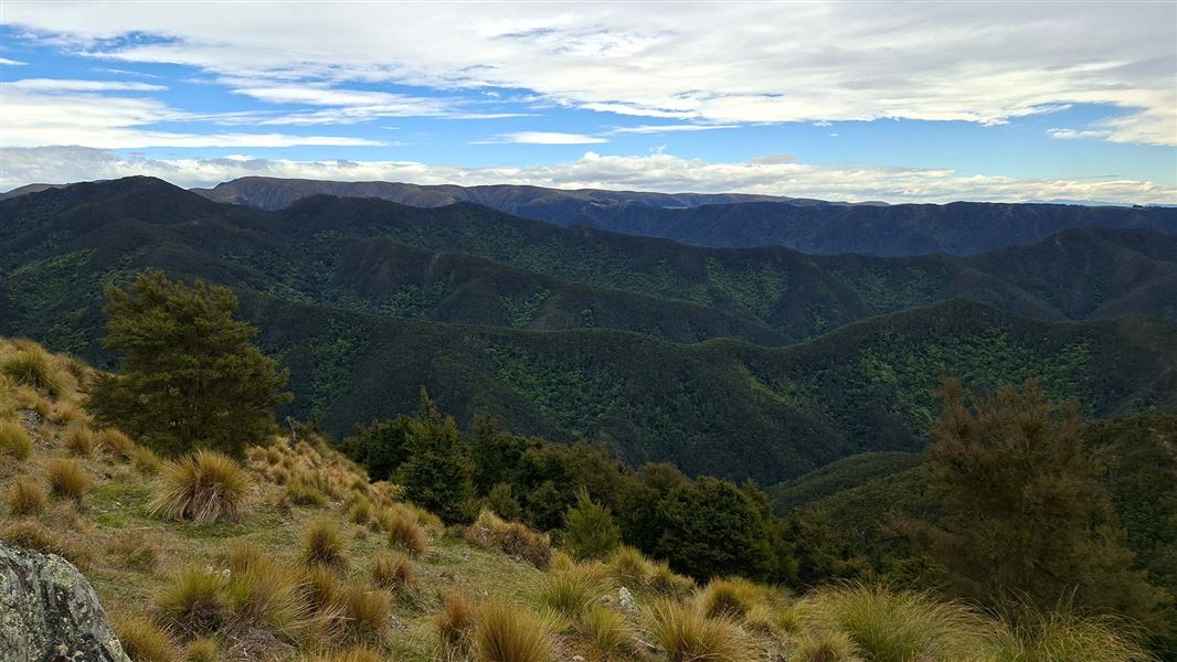
Explore ridges covered in regenerating kānuka forest, tussock clearings and steep broadleaf/podocarp gullies.
21 km
Mt Misery Road Carpark to Staircase Hut via Tabletop
Time: 6 hrs
Distance: 12.5 km
Starting at the carpark on Mt Misery Road, follow the route downhill for 1.5 km to the Waianakarua River Middle Branch/and junction for the circuit route. Take care when wet as it is steep and slippery in places, particularly the final section to the river.
Turn left at the river and continue on the riverbed downstream on the true left side for approximately 100 m, before markers indicate a crossing to the true right. The route takes you along the forested river terrace before leading you up the spur onto Tabletop. Take care as parts of this section are exposed to steep cliffs.
Once on Tabletop the route is relatively flat and follows an historic farm track through regenerating kānuka/mānuka scrub and grassy clearings down to the old stock yards at Sweetwater creek.
Follow markers through the stock yard clearing and cross the creek to head up onto the ridge to Staircase Hut.
Mt Misery Road Carpark to Staircase Hut via Staircase Ridge
Time: 5 hrs
Distance: 8.5 km
Starting at the carpark on Mt Misery Road, follow the route downhill for 1.5 km to the Waianakarua River Middle Branch/and junction for the circuit route. Take care when wet as it is steep and slippery in places, particularly the final section to the river.
At the river, head upstream for approximately 500 m, sticking to the true right side. The route up the spur onto Staircase Ridge is marked with arrows on a large totara tree overhanging the riverbed.
Follow the route along Staircase Ridge via Pt473 and Pt499 before eventually descending 'Staircase Spur' to Staircase Hut.
Bookings
Staircase Hut is privately owned. For booking information visit Staircase Hut.
Turn onto Mt Misery Road, 4 km south of Herbert on SH1. After 6 km of unsealed road you will reach the carpark on the left. There is a DOC sign and track entrance sign. The road to The Waianakarua Circuit carpark is unsealed but suitable for 2WD.
Logging trucks and farm vehicles use this road frequently, keep to the left, drive with your headlights on, and drive to the conditions.
Essential safety
Only attempt this track if:
- you are fit and experienced – on the route you will have to scramble up steep rock, cross rivers, and avoid hazards by following markers
- track and weather conditions are good on the day
- you have the right equipment, including a personal locator beacon – see the Day hikes gear list.
Stay safe when crossing rivers
If you plan to cross unbridged rivers, know how to cross safely and be prepared for if you cannot cross.
Do not cross if the river is flooded, you cannot find safe entry and exit points or are unsure it’s safe. Turn back or wait for the river to drop. If in doubt, stay out.
NIWA river flow forecasts: View a video of national followed by regional river flows
Fires prohibited
Fires could rapidly destroy this special place and put you and others at risk. Do not light fires.
Weather
Weather can deteriorate and creeks can rise rapidly due to heavy or prolonged rain. Make a safe decision and be prepared to turn back.
This is a remote backcountry hike
Be prepared and always take a personal locator beacon.
Stay safe in the outdoors
- Choose the right trip for you. Learn about the route and make sure you have the skills for it.
- Understand the weather. Check weather forecasts.
- Pack warm clothes and extra food. Check gear lists.
- Share your plans and take ways to get help. Leave your intentions with a trusted contact and take a distress beacon.
- Take care of yourself and each other.
DOC Customer Service Centre
| Phone: | 0800 275 362 |
| Email: | dunedinoffice@doc.govt.nz |
| Address: | Ōtepoti / Dunedin Office |