Image gallery
This is a Tohu Whenua heritage site. Located in stunning landscapes and rich with stories, these sites offer some of our best heritage experiences.
About the walk
- Views of Pegasus Bay and Lyttelton Harbour
- WWII gun emplacements and Antarctic heritage
- Gravel track with steady ups and downs and high cliffs
Most people walking Awaroa/Godley Head Loop Track:
- start at Te Onepoto/Taylors Mistake
- walk to Awaroa/Godley Head via the Pilgrims Way coastal track
- return to Taylors Mistake via Breeze Bay.
You can also access the Godley Head gun emplacements directly from Godley Head car park.
Taylors Mistake to Godley Head via Pilgrims Way
1 hr 45 min / 4.1 km
Easy to intermediate walking track
Access to the loop track is signposted from Taylors Mistake car park, by the toilet block. There are some steep, rocky sections as you climb above the beach past the baches at Rotten Row.
Climb past Boulder Bay to two gun platforms at Taylor Battery. From here, you can take a side trip (10 min return) to historic Scott’s Cabin.
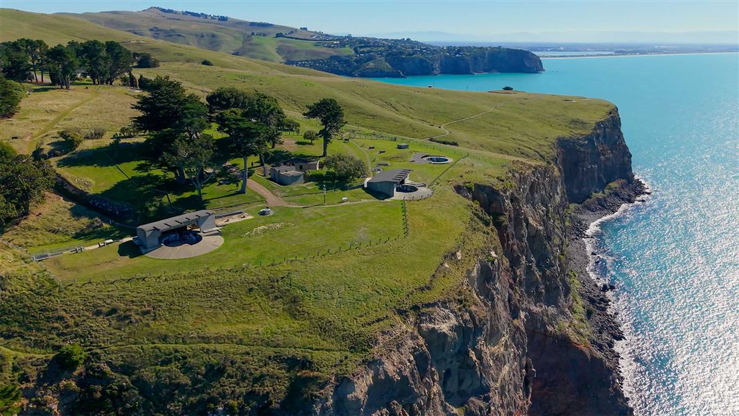
The track then climbs up to the headland with towering 120-metre high cliffs and the Awaroa/Godley Head coastal defence battery.
You can explore:
- World War 2 gun emplacements
- an underground magazine where ammunition was stored
- historic military buildings.
On a fine day, enjoy panoramic views over the city towards New Brighton Beach and beyond to Pegasus Bay and the Kaikōura Ranges.
Godley Head to Taylors Mistake via Breeze Bay and Black Rock
1 hr 45 min / 5.6 km
Easy to intermediate walking track
The loop track carries on around the headland from Godley Head. You’ll pass the old engine room, miniature range and battery plotting room.
From Godley Head car park, the track climbs high above Breeze Bay, past two WWII observation posts. Get sweeping views of:
- Lyttelton Harbour/Whakaraupō
- Banks Peninsula/Te Pātaka o Rākaihautū.
The track then drops back down to the small car park at Breeze Col on Summit Road.
Cross Summit Road at Breeze Col with care. Follow the signposted track to Taylors Mistake via Black Rock downhill to the junction with Pilgrims Way coastal track.
Turn left to return to Taylors Mistake car park (15 min).
No mountain biking
Mountain bikes are not permitted on Awaroa/Godley Head Loop Track.
For nearby mountain biking tracks, see Christchurch City Council’s Awaroa/Godley Head web page.
Awaroa/Godley Head Loop Track is 40 to 50 min by car from central Christchurch. You can start the walk at three different car parks.
Taylors Mistake car park
Taylors Mistake car park is 40 min by car from central Christchurch. Most visitors begin and end the walk here.
From Sumner, drive over the hill to Taylors Mistake. The car park is at the end of Taylors Mistake Road.
Taylors Mistake car park is managed by Christchurch City Council. It has:
- free parking for cars and campervans
- no marked mobility spaces.
Godley Head car park
Godley Head car park is 50 min by car from central Christchurch, at the end of Summit Road.
Godley Head car park is the main access point for the Awaroa/Godley Head heritage site. You can also begin and end the track here.
The car park has:
- free parking for cars and campervans
- no marked mobility spaces.
Opening hours
Godley Head car park is open from 8 am to 8 pm.
The gate is locked outside these hours. After-hours parking is available on the roadside.
Driving on Summit Road
Summit Road to Godley Head is narrow with sharp corners and steep drops. Keep left, reduce speed and look out for cyclists.
Breeze Col car park
A small car park at Breeze Col also provides access to Awaroa/Godley Head Loop Track. It is labelled ‘Godley Head Loop Track Car Park’ on Google Maps.
Mana whenua
Te Hapū o Ngāti Wheke hold mana whenua or customary authority over this special place.
Safety and hazards
- Cliff edges: Godley Head has high, unfenced cliffs and steep drops. Stay away from the edge of the track and keep children close.
- Falling rock: There are rockfall hazards along the track. No stopping where indicated.
- Historic structures: Some historic structures at Godley Head are unfenced, with uneven surfaces and hidden drops. Take care when exploring.
- Unmaintained tracks: The track between the gun emplacements and the Godley Head car park has been rerouted for safety reasons. Respect all track closure signs.
- Contaminated soil: Soil containing asbestos is buried at Godley Head. Follow all safety signs and keep dogs on a lead.
When to go
- Awaroa/Godley Head Loop Track is very exposed, with no shade. It can be very hot, or cold, wet and windy, in all seasons.
- New Zealand weather changes quickly. Check the weather forecast before you go, and be prepared.
Plan your visit
- Bookings are not required for Awaroa/Godley Head Loop Track.
- Toilets and accessible toilets are located at Taylors Mistake car park, Godley Head car park and Awaroa/Godley Head Campsite.
- Tap water is available at Taylors Mistake car park, Godley Head car park and Awaroa/Godley Head campsite. It’s best to treat before drinking.
- Picnic tables are provided near Godley Head car park and at Awaroa/Godley Head Campsite.
- Camping is available at Awaroa/Godley Head Campsite. You can also book Lighthouse Cottage.
- Food and petrol can be found in Sumner (10 min by car).
- Mobile phone coverage can be unreliable.
What to take
Care for nature
- Rubbish bins are not provided. Take your rubbish with you.
- Dogs are major threats to little penguins/kororā and New Zealand fur seals/kekeno. Keep dogs on a lead.
- Farm animals graze here. Give them space and shut gates behind you.

Seabirds and marine mammals
The ocean and rocky coastline around Awaroa/Godley Head are home to seabirds and unique marine mammals.
You might see:
- black-backed gull/karoro
- white-fronted tern/tara
- New Zealand fur seal/kekeno
- Hector’s dolphin.
Little penguins/kororā
Little penguins/kororā are being returned to Boulder Bay. They have a distinctive smell, which you’ll notice from the track.
World War 2 gun emplacements
From 1939 to 1945, the coastal defence battery at Awaroa/Godley Head protected Lyttelton/Whakaraupō from enemy warships.
Hundreds of military personnel were based here, including 150 members of the Women’s Auxiliary Army Corps.
Awaroa/Godley Head coastal defence battery
Pilgrims Way and Boulder Bay baches
Awaroa/Godley Head Loop Track follows a costal path originally used by holiday makers to access their baches at Boulder Bay. It was known as the Pilgrims Way.
In the late 1890s and early 1900s, Christchurch families began building baches from simple materials along the shoreline between Taylors Mistake and Boulder Bay.
Some original baches were cave dwellings close to the sea. You can see the remains of some of these from the track.
Scott’s Cabin
Scott’s Cabin is a small hut originally designed for British explorer Captain Robert Scott’s 1910–13 Terra Nova expedition to Antarctica. It was relocated to Godley Head from Crichton Hill, above Sumner, in 2013, following the Canterbury earthquakes.
The cabin’s interior isn’t open to the public. You can climb narrow stairs to a viewing platform on the roof. Information panels explain the cabin’s history.
Arthur's Pass National Park Visitor Centre
| Phone: | +64 3 318 9211 |
| Email: | arthurspassvc@doc.govt.nz |
| Address: | 104 West Coast Road Arthur's Pass 7654 |
| Hours: | Visitor centre hours and services |