The intertwining braids of the mighty Rakitata River criss-cross a wide gravel bed on a 121 km journey to the sea. The catchment is large – more than 177,000 ha.
It contains an array of diverse ecosystems and habitats that support rare native birds, algae, plants, invertebrates and fish.
The river supports many people who live and work in its catchment. This weaves a rich tapestry of overlapping cultural, environmental and social values.
Image gallery
River name and meaning
The name Rakitata (the Kāi Tahu pronunciation of Rangitata) speaks of the significance of the awa as a travel route for manawhenua, Te Rūnanga o Arowhenua. It literally means ‘the stairway to Ranginui’ the sky father.
Rangi means ‘heavens or sky father’, signifying the ascension to the wānanga, a place of learning and spirituality where communion with the atua (gods) can take place. ‘Tata’ means close by. Other interpretations allude to the physical attributes of the catchment, which can be translated as ‘shrouded peak’ or ‘day of the lowering clouds’.
Stories from the river
Kōrero nā te awa Rakitata – Stories from the Rangitata is a series of videos created for Ko te Whakahaumanu o te Rakitata Awa – the Rakitata River revival programme.
Learn about the river by hearing stories from some of the people who know it best: mana whenua, rangers, farmers, nursery workers, fishers and more.
Kōrero nā te awa Rakitata – Stories from the Rangitata - YouTube
Maps of the catchment
Map of the Rangitata River catchment (PDF, 968K)
Maps with Māori place names:
- Upper Rangitata River (PDF, 3,104K)
- Lower Rangitata River (PDF, 2,263K)
- Overview of Rangitata River (PDF, 1,973K)
Physical features of the river
Rakitata is a braided river
Braided rivers are made up of channels that weave downstream between islands of gravel. They change course regularly, especially after heavy rain and floods. Braided rivers are globally rare. More than half of New Zealand’s braided rivers are in Canterbury.
Source and tributaries
The river begins in the headwaters of the Clyde/Te Awa a Moinaina and Havelock/Te Awa o Tukua Rivers, which converge to form the Rakitata. These tributaries are fed by springs, streams, wetlands and melting glacier ice in the Southern Alps/Kā Tiritiri o te Moana. Other large tributaries are the Lawrence and Potts rivers. Smaller tributaries include Bush stream/O Rae Korokio and Forest creek/Totara.
Because the river begins in the mountains, its flows are generally lowest in winter and highest in early summer due to melting snow.
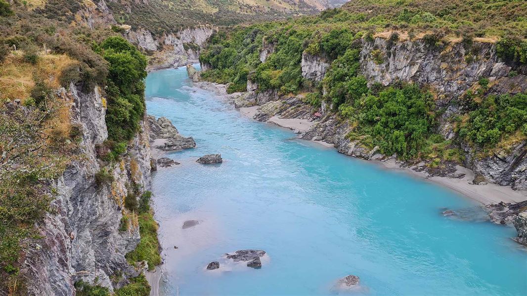
Above and below the Rakitata Gorge
The Rakitata Gorge forms a natural division at the river’s mid-point, with different land uses, ecology and character above and below. The upper part is defined by its mountainous backdrop, where there are extensive ecologically rich spring-fed streams and wetland habitats.
The lower part traverses the flat Canterbury Plains/Kā Pākihi-whakatekateka-a-Waitaha that have become the focus of more intensive dairy farming since the 1990s. The river then flows into the Pacific Ocean approximately 30 km northeast of Timaru/Te Tihi-o-Maru.
Hāpua, river mouth
The hāpua (river mouth) is a distinctive feature. Hāpua are long, narrow and shallow river mouth lagoons partially enclosed by a gravel barrier beach. They mainly contain freshwater, rather than the salty water found in estuaries. Unlike many smaller rivers with hāpua in Canterbury, the mouth of the Rakitata is nearly always open.
Native species present
A range of taonga, rare and endangered species are present in the catchment. The upper part of the catchment has been identified as a globally outstanding area of native bird habitat.
See also fish and invertebrate surveys.
Birds
The Rakitata riverbed area provides nationally significant breeding habitat for more than 88 species of birds, including threatened and at-risk species. These include black-billed gull (Nationally Critical), black stilt (kaki, Nationally Critical), black-fronted tern (Nationally Endangered), and wrybill, banded dotterel and Caspian tern (Nationally Vulnerable).
More than 60% of all wrybill nests are in this area. These birds are at-risk of predation from ground and avian predators like stoats and black-backed gulls. Intensive pest control and landscape-scale weed control (to prevent nesting areas being overrun by woody weeds) are therefore important to protect this species.
Fish
17 native fish species have been recorded in the river and 11 of these have a threatened or at-risk conservation status. Upland longjaw galaxias (Galaxias prognathus) and lamprey (Geotria australis) are Nationally Vulnerable.
The Rakitata Gorge is a natural barrier to fish mighration. Migratory species are rarely found above the gorge and non-migratory species are rarely found below it.
The river is a stronghold for Stokell's smelt. Large shoals of common and Stokell’s smelt move into the river in spring and summer to spawn. This influx is significant for the river’s ecology as smelt provide food for larger fìsh and bird species in the Iower river.
Plants
Landscape-scale processes like mountain uplift, glaciations and erosion have created varied landforms that support a wide range of plant communities in the catchment. 138 native plant species have been identified in the stream channels, wetlands, riverbeds and river margins of the catchment. 14 of these are threatened or at-risk.
The river’s gravel beds support miniature plants that can survive the desert-like summer conditions and the winter freeze. Racomitrian mosses make a soft carpet cover over stable raised terraces. Rhoulia waft their honey-like scent across the riverbed on hot summer days. Scrambling vines of Muehlenbeckia axillaris provide habitat for copper butterflies. The yellow and violet flowers of Carmichaelia corrugata and crasspedia stand out against the grey gravel riverbed.
Invertebrates
Invertebrates like mayflies feed on periphyton (algae stuck to rocks and gravel in the riverbed), river plants, dead leaves and wood, and each other. They are also a food source for fish and birds.
Invertebrates associated with Rakitata waterways and riverbeds that have a threatened or at-risk conservation status include the:
- red katipo spider (Latrodectus katipo)
- robber fly (Neoitamus smithii)
- a grasshopper (Brachaspis ‘lowland’)
- a stonefly (Zelandobius edensis)
- a mollusc (Austropeplea tomentosa).
Lizards
10 species of native lizard have been recorded in the Rakitata River area.