Video
Note: True left and true right refer to the side of the valley or river when facing and looking downstream.
Car park to Welcome Flat Hut
Time: 7 hr
Distance: 18 km
Follow Copland Track to Welcome Flat Hut via Architect Creek Hut.
Welcome Flat Hut to Douglas Rock Hut
Time: 3 hr
Distance: 7 km
The suspension bridge near Welcome Flat Hut leads across to the true left of the Copland River and onto a series of extensive grassy river flats. Along the flats there are fine views into the Ruera Valley and the Navigator Range beyond, while Mount Sefton and the Footstool rear up behind The Sierra Range, reaching heights over 2000 m above the valley floor.
Occasionally the track wanders into low forest but returns to the grassy flats before crossing the multiple channels of Scott Creek. This creek can be extremely hazardous in wet weather.
Beyond Scott Creek the track enters the forest again and begins to climb gradually above the upper gorge. There are a number of open slips to cross with views up and down the river. Eventually you will reach the swing-bridge across Tekano Creek and the views to the upper valley will open out in front of you. Douglas Rock Hut (eight bunks) is nestled in a forest glade just across the bridge. On a clear day the views from the hut are expansive.
Above Douglas Rock Hut
Past Douglas Rock Hut, a marked route continues up the Copland Valley. Avalanche and flood risk is high on this route. This route should only be attempted by those with alpine experience, mountaineering skills and equipment. From Douglas Rock Hut, the route ascends through subalpine vegetation with improving views of the high mountain peaks surrounding the upper Copland River.
Marked by cairns and poles, the route sidles above the river, with Aoraki/Mount Cook coming into view near Fiddian Creek. The route continues to sidle until directly below Copland Pass, at which point it zigzags its way up the steep slopes into an alpine basin.
Warning
The route ends at the alpine basin. Do not attempt to climb to and cross Copland Pass unless you have a high level of mountaineering experience and appropriate mountaineering equipment. Over the years a number of climbers have died attempting to cross Copland Pass.
Access on the eastern side of the divide is difficult due to erosion. It is strongly recommended that you do not attempt to cross Copland Pass from the west. Contact the DOC Aoraki/Mount Cook National Park visitor centre for more information.
Understand if you are ready for the Copland Valley Track
Watch the NZ Mountain Safety Council’s walk-through video which takes you through how to prepare for this track. Including facilities, key decision points, hazards and typical conditions for the area.
Copland Valley Track guide video.
Experience: Suitable for well-equipped and experienced backcountry trampers and mountaineers only – navigation and survival skills required. The track beyond Welcome Flat Hut is more difficult as the conditions underfoot are rougher and the majority of creeks are unbridged and may be impassable during and after heavy rain.
Best time to go: Summer and autumn
Maps: NZTopo50: BX14 Gillespies Beach; BX15 Fox Glacier
Safety
Hazards: Flooded rivers, rock fall and avalanche.
Avalanches are possible in the upper valley – particular care is required throughout winter and spring.
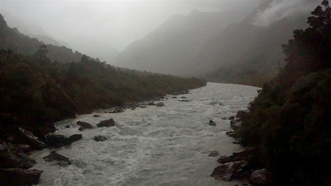
Rivers and streams
This valley is subject to flooding at any time of year. Do not attempt this trip in bad weather or when rain is forecast. If rivers and side streams are in flood, do not attempt to cross. The Copland River can flood sections of track making it impassable.
Stay safe when crossing rivers and streams
If you plan to cross unbridged rivers or side streams, know how to cross safely and be prepared for if you cannot cross.
Do not cross if the river or stream is flooded, you cannot find safe entry and exit points or are unsure it’s safe. Turn back or wait for the river to drop. If in doubt, stay out.
NIWA river flow forecasts: View a video of national followed by regional river flows
The Copland Track was built by the Tourist and Health Resorts Department to provide a tourist route across the Southern Alps linking the West Coast with the Hermitage, a popular lodge at Mt Cook.
In 1901 New Zealand became the first country in the world to form a government department to develop and promote tourism. Along with places such as Rotorua, the Chateau (Tongariro) and Milford, the Hermitage and the Southern Alps were becoming popular destinations with the growing number of international tourists.
Construction
The track was constructed over several years from c1901–1913. Construction was slow and hampered by labour shortages. The harsh alpine weather made it impossible to work on the track during winter, so work was restricted to the summer months. Work was also delayed by the unstable nature of the landscape and high rainfall in the area. This meant sections of track often had to be rebuilt due to damage from flooding, erosion and landslides.
At first the track was little more than a blazed line through the bush that had the tendency to become quickly overgrown. Eventually it was widened and developed into a pack track.
There were no other tracks of this scale constructed solely for tourist use on the West Coast. The doggedness with which the completion of the track was pursued by the Government highlights the importance the Copland Track had in their plans for tourism in the South Island.
Welcome Flat hot pools
During the construction of the track, workers came across the natural hot pools at Welcome Flat. This was a great find – thermal attractions were proving popular with visitors and seen by the government as key to stimulating tourism. The route quickly became a popular tourist trip and was one of the key tourist attractions that sustained the fledgling tourist industry in the area.
Stay safe in the outdoors
- Choose the right trip for you. Learn about the route and make sure you have the skills for it.
- Understand the weather. Check weather forecasts.
- Pack warm clothes and extra food. Check gear lists.
- Share your plans and take ways to get help. Leave your intentions with a trusted contact and take a distress beacon.
- Take care of yourself and each other.
Westland Tai Poutini National Park Visitor Centre
| Phone: | +64 21 947 990 |
| Email: | westlandnpvc@doc.govt.nz |
| Address: | 69 Cron Street Franz Josef Glacier 7856 |
| Hours: | Visitor centre hours and services |