Image gallery
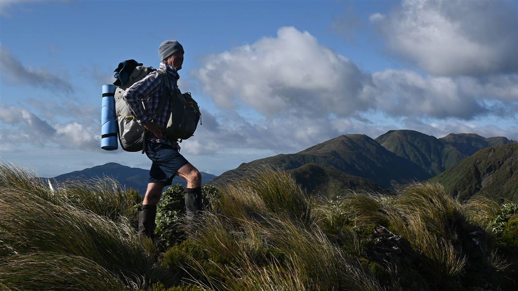
This route is a very challenging tramp and will not be suitable for most trampers.
We strongly recommend only attempting this route if the weather forecast is good and if you have very high fitness, exceptional backcountry tramping skills, and are carrying the right gear (including a distress beacon, navigation aids, spare food, a first aid kit, a survival kit and an emergency shelter).
The Tararua Main Range Traverse (Putara to Kaitoke) can be tramped in sections.
Putara Road End to Herepai Hut
Time: 2-3 hours
Distance: 5 km
Track: Advanced tramping track
The track begins at the end of Putara Road in Mangatainoka Valley. A swing bridge crosses the Mangatainoka River and then the track follows the true left of the river to another, larger swing bridge around 1.5 km upstream.
From the top swing bridge, the track climbs steeply to Herepai Ridge. At the track junction, the track to the right leads 1.5 km to Herepai Hut.
Herepai Hut to Herepai Peak
Time: 1 hour
Distance:1 km
Track: Advanced tramping track
From Herepai Hut, continue up the track to Herepai Peak.
Herepai Peak to Dundas Hut (no DOC marked route)
There is no marked route between Herepai Peak and Dundas Hut. Terrain and route descriptions are available via some tramping clubs.
Dundas Hut to Arete Hut (no DOC marked route)
There is no marked route between Dundas Hut and Arete Hut. Terrain and route descriptions are available via some tramping clubs.
Arete Hut to Dracophyllum Hut (partially marked)
Time: 2-3 hours
Track: Includes Expert route and Advanced tramping track sections
The route between Arete Hut and Dracophyllum Hut is currently partially marked. From Arete Hut, continue along the tops to Pukematawai. Just below the Pukematawai summit, you meet the Te Araroa track. Follow this to Dracophyllum Hut.
Dracophyllum Hut to Nichols Hut
Time: 5.3 km
Distance: 3-4 hours
Track: Advanced tramping track
Continue following the track along the main range. As you approach Nichols peak the track leaves the bush.
The hut is situated on a side track near Nichols peak.
Nichols Hut to Anderson Memorial Hut
Time: 2-3 hours
Track: Advanced tramping track
From Nichols Hut, continue along the main range. The route climbs to the summit of Mt Crawford, then continues on to Junction Knob.
From Junction Knob, continue along the main range to Anderson Memorial Hut.
Anderson Memorial Hut to Aokaparangi Hut
Time: 2-3 hours
Track: Advanced tramping track
The track continues along the main range and leads over Kahiwiroa. It then climbs to the top of Aokaparangi.
The hut is on the bush line below Aokaparangi, accessed from a track near the summit.
Aokaparangi Hut to Maungahuka Hut
Time: 3-4 hours
Track: Advanced tramping track
From Aokaparangi Hut, follow the hut access track back to the top of Aokaparangi. Continue following the track along the main range, past Wright (1196m) and Simpson (1174m).
The route then climbs towards Maungahuka. The hut is situated beside a tarn near the Maungahuka summit.
Maungahuka Hut to Kime Hut
Time: 7-9 hours
Track: Expert route
Follow the route to the junction at Maungahuka summit, then continue on the main range route following the sign towards Kime Hut.
The route passes over the Tararua Peaks. The Tararua Peaks are a notoriously steep double peak, formed by the Tuiti and Tunui summits. They are traversed with the help of a long ladder. Take great care.
After the Tararua Peaks, continue following the route over McIntosh (1286), Yeates (1205m), Vosseler (1198m) and Boyd-Wilson Knob (1138m).
At Bridge Peak, the route joins the Southern Crossing route. Follow the Southern Crossing to Kime Hut.
Kime Hut to Alpha Hut
Time: 5–6 hours
Track: Advanced tramping track
The Southern Crossing route leads from Kime Hut over Field Peak to Mount Hector (1,529 m). The exposed ridge of the Dress Circle takes you to the top of Aston (1,376 m). Continue along the ridge route over Alpha (1,361 m) and descend to Alpha Hut.
Alpha Hut to Kaitoke
Time: 8-9 hours
Track: Advanced tramping track
From Alpha Hut, the track descends to the saddle at Hells Gate. The track follows Marchant Ridge, a long stretch of bush that is rough underfoot and muddy when wet. The track ends at a car park on Kiwi Ranch Road, at Kaitoke.
The Tararua Main Range Traverse starts at the end of Putara Road, which is around 20 minutes’ drive from Eketāhuna.
This is a very challenging trip
Make sure you have the fitness and skills to complete it safely.
Much of the route is fully exposed to extreme, fast-changing weather. Low visibility, high winds and storms are common. There are sections with no marked route, where you will have to navigate for yourself. It is steep and rugged.
You need:
- excellent backcountry tramping skills
- to know how to assess the weather and decide how to respond
- good navigation skills, including in low visibility conditions and untracked alpine areas
- survival skills
- a high level of fitness
- confidence with heights and good balance
- to have a plan for what alternative routes and escape routes you can use
Pack emergency equipment
Don’t pack light, pack prepared. If you are injured, you need to be able to wait, summon help, and survive until help arrives. You also need to be ready for weather delays, which are common in the Tararua Forest Park.
To be ready for an emergency, always carry:
- A distress beacon
- An emergency shelter
- Lots of warm and waterproof clothing
- A first aid kit
- A head torch and spare batteries
- Plenty of spare food, in case you are delayed
- Navigation aids
Carry plenty of water, as there is none along the route except at the huts.
Find a full packing list here.
Check the weather and only attempt the traverse in good weather
We strongly recommend that you do not tramp along the main range during bad weather.
Weather forecast for Kime Hut and Arete Hut
There are many steep drops
The terrain is extremely steep and you will have scramble over very narrow sections of ridge and rock, with steep drops beside you. There are parts where you will need to use chains and a ladder. In some places a fall could be fatal.
Stay safe in the outdoors
- Choose the right trip for you. Learn about the route and make sure you have the skills for it.
- Understand the weather. Check weather forecasts.
- Pack warm clothes and extra food. Check gear lists.
- Share your plans and take ways to get help. Leave your intentions with a trusted contact and take a distress beacon.
- Take care of yourself and each other.
Wellington/Kapiti information
| Phone: | +64 3 546 9339 |
| Email: | nelsonvc@doc.govt.nz |
| About: | Whakatū/Nelson visitor services provide information for this area |