Image gallery
This circuit includes unmarked alpine tramping and physically demanding backcountry tracks. It is suitable only for experienced, fit, well-equipped trampers in good weather.
Putara Road end to Herepai Hut
Time: 3 hr
Distance: 5 km
The track begins at the end of Putara Road in Mangatainoka Valley. A swing bridge crosses the Mangatainoka River and then the track follows the true left of the river to another, larger swing bridge around 1.5 km upstream.
From the top swing bridge, the track climbs steeply to Herepai Ridge. At the track junction, the track to the right leads 1.5 km to Herepai Hut.
Herepai Hut to Dundas Hut (no managed route)
From Herepai Hut, follow the sign to Herepai Peak. It is 1 km from the Herepai Hut to Herepai Peak, but takes around 1 hour because of the tussock and substantial altitude gain.
There is no managed or marked route between the Herepai bushline and Dundas Hut. We strongly recommend only attempting this section if the weather is good, you have excellent backcountry tramping skills and are carrying the right gear (including a distress beacon, navigation aids and an emergency shelter). Terrain and route descriptions are available via some tramping clubs.
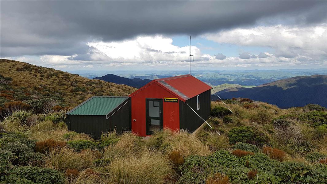
Dundas Hut to Cattle Ridge Hut
Time: 5 hr
Distance: 5.2 km
From Dundas Hut, the track descends all the way into the upper Ruamahanga valley.
There is no bridge over the Ruamahanga River, so assess it carefully and judge whether it is safe to cross.
After crossing the river, the track climbs steeply up to Cattle Ridge. Cattle Ridge Hut is situated on the open tops with excellent views over the Wairarapa.
Cattle Ridge Hut to Roaring Stag Hut
Time: 2 hr
Distance: 2.3 km
From Cattle Ridge Hut, the track descends steeply into the Ruamahanga valley. It crosses a bridge over the Ruamahanga River then arrives at Roaring Stag Hut.
Roaring Stag Hut to Putara Road end
Time: 4 hr
Distance: 7 km
From Roaring Stag Hut, take Roaring Stag Track. The track crosses several streams (unbridged), then climbs steadily to meet the junction with the Putara-Herepai Track. From this junction, follow the track back down into the Mangatainoka Valley and to Putara Road end.
The Dundas Circuit is accessed from the end of Putara Road.
This is a challenging trip – read about it and make sure it’s right for you
This circuit requires excellent backcountry tramping skills and good equipment.
These is no marked or managed route for a section of this circuit (from Herepai bushline to Dundas Hut), so you need very good navigation skills, including in low visibility conditions.
The section of unmarked alpine tops is fully exposed to extreme, fast-changing weather. Low visibility, high winds and storms are common. You must know how to assess the weather and judge whether it is safe to proceed.
You also need river crossing skills.
There are several long climbs and long descents, which are physically demanding and need good fitness. The tracks are rough, steep, muddy and have lots of tree roots.
Check the weather and only try this circuit in good weather
We strongly recommend that you do not tramp this circuit during bad weather – high wind, low visibility and cold temperatures will make the alpine sections very difficult. Rain can flood the Ruamahanga River and various streams, making them impassable. Winter conditions will also make it very challenging.
Weather forecast for Arete Hut
You need navigational and emergency equipment – don’t pack light, pack prepared
This circuit includes a lot of unmarked tops travel and losing visibility is common on the Tararua tops. It’s essential to carry navigational and survival equipment, including:
- A distress beacon
- An emergency shelter
- A survival kit
- Navigation aids, like a map and compass (and be confident using them in low visibility conditions)
- Spare food and water, in case of delays
- Headtorch/flashlight and spare batteries
- Warm and waterproof clothes
Stay safe when crossing rivers
If you plan to cross unbridged rivers, know how to cross safely and be prepared for if you cannot cross.
Do not cross if the river is flooded, you cannot find safe entry and exit points or are unsure it’s safe. Turn back or wait for the river to drop. If in doubt, stay out.
NIWA river flow forecasts: View a video of national followed by regional river flows
Stay safe in the outdoors
- Choose the right trip for you. Learn about the route and make sure you have the skills for it.
- Understand the weather. Check weather forecasts.
- Pack warm clothes and extra food. Check gear lists.
- Share your plans and take ways to get help. Leave your intentions with a trusted contact and take a distress beacon.
- Take care of yourself and each other.
Wellington/Kapiti information
| Phone: | +64 3 546 9339 |
| Email: | nelsonvc@doc.govt.nz |
| About: | Whakatū/Nelson visitor services provide information for this area |