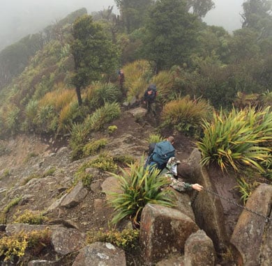
Mahaukura Track
Image: Sean Willcock | Creative Commons
Mahaukura Track
Time: 4–6 hr one way
Distance: 9 km
From Grey Road car park, follow the track to Wharauroa Lookout then on for another 30 min to Mahaukura. The track undulates over small peaks and is uneven underfoot.
From Mahaukura, the track descends steeply before climbing again towards Pirongia summit viewing tower. There are climbing chains on difficult parts of the track
This track can also be accessed off O’Shea Road via the Wharauroa Track.
Getting there: The track starts 11 km north of Pirongia. 5.5 km north of Pirongia, turn off SH39 onto Te Pahu Road. Take the first left turn into Hodgson Road, then turn left turn into Grey Road and follow this to the end.
Tirohanga Track
Time: 3–5 hr one way
Distance: 6.5 km
The track starts from Corcoran Road, climbs to Ruapane then traverses an undulating ridge on uneven ground before passing Tirohanga Bluff, a pinnacle of hard lava signifying its volcanic origins. The track then descends and climbs before reaching the Pirongia summit. There are climbing chains on difficult parts of the track
On a clear day look for Mt Taranaki and Mt Ruapehu in the distance.
Getting there: 5.5 km north of Pirongia, turn off SH39 onto Te Pahu Road, which is signposted for Pironga Forest Park. After 5.6 km, turn into Corcoran Road and follow this to the end.
Tirohanga to Mahaukura round trip
Time: 8–11 hr return
Distance: 17 km
This is a popular round trip for people overnighting at Pāhautea Hut. Cross from Grey Road car park to Ruapane via the Mangakara Nature Walk and Link Track then follow the Tirohanga Track to the summit viewing tower. Return via Mahaukura Track to Grey Road. This is the easier circuit rather than doing it the other way round via Mahaukura then Tirohanga.
Always pack plenty of warm clothing and a waterproof raincoat. Bring a torch and spare batteries, in case you find the walk takes you longer than expected and it starts to get dark. Find a full list of what to pack
A good level of fitness is required for these tracks.
Expect steep and challenging sections of track. You will have to scramble up rocky ridges, clambering over boulders and using chains to keep your balance. There are some steep drops near the track.
Bell Track and Tahuanui Track do not require climbing chains, so they are good alternatives if you are not confident on very rough, uneven terrain.
Water is difficult to find, especially in summer, so be sure to take sufficient drinking water with you.
Because of poorly drained soils, the tracks can be very muddy, especially after rain.
Check the Pirongia Mountain weather forecast – NIWA website.
Stay safe in the outdoors
- Choose the right trip for you. Learn about the route and make sure you have the skills for it.
- Understand the weather. Check weather forecasts.
- Pack warm clothes and extra food. Check gear lists.
- Share your plans and take ways to get help. Share directly or use the Outdoor Intentions form or Plan My Walk. Take a distress beacon.
- Take care of yourself and each other.
DOC Customer Service Centre
| Phone: | 0800 275 362 |
| Email: | waikato@doc.govt.nz |
| Address: | Te Rapa Base |
