This significant and isolated scenic reserve has a feeling of remoteness. It shows many of the gold extraction technologies of the 19th century: a stamper battery, water wheel and church.
It became known as the Serpentine, after the winding path of nearby Waimonga Creek.
Good conditions for four-wheel driving are necessary to access Serpentine Scenic Reserve. Be aware you cannot travel directly to the battery by vehicle.
If you do not have a vehicle with four-wheel drive, you can walk or bike to the reserve from Poolburn Dam. A topo map and navigational skills are essential.
There is a section of track 400 metres before Serpentine Church that is damaged and impassable by vehicle.
You can drive up to this damaged section, park, and walk the last 400 metres to view Serpentine Church and the diggings.
Vehicle access to the reserve
The reserve is about an hour's drive from Alexandra. Drive to Poolburn Dam on Old Dunstan Road and then turn off onto Long Valley Ridge Road. Be aware Long Valley Ridge road can be closed, so contact Central Otago District Council to check it is open before you travel.
Long Valley Ridge road is also closed to vehicles from the Tuesday after Queens Birthday Weekend until 30 September each year.
Stay on the main road while travelling, and only use it when conditions are dry.
Battery access
To access the battery there is a marked walking track, which is 1 hr return walk from Long Valley Road. There is no vehicle access to the battery.
- To mountain bike from Poolburn Dam to Serpentine Church is 2-3 hr.
- To walk from Poolburn Dam to Serpentine Church is 5 hr.
Much of the gold mining heritage is hidden beneath this tussock landscape. These areas are easily destroyed so keep your vehicles on the formed road.
The discovery of gold in 1863 transformed this remote area into a vibrant gold-mining town. A settlement quickly sprang up, with two store-hotels, a church, blacksmiths, a cemetery, and huts of sod, wood and thatch with gardens and potato-storage pits. The formed road you come in on follows part of the original dray track used by miners. The Serpentine reached its peak population (150 Chinese and 80 Europeans) around 1873.
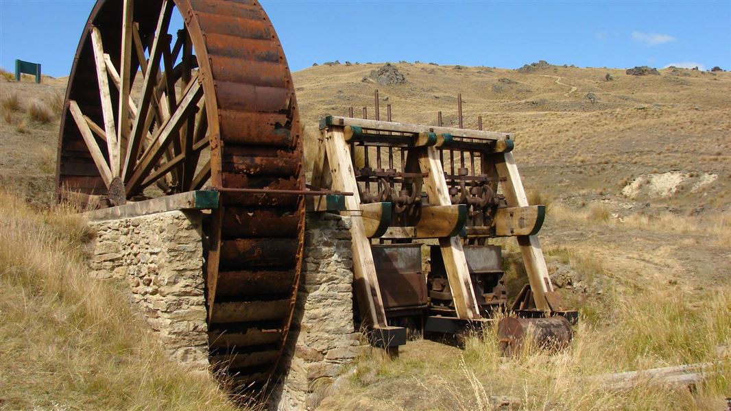
The Serpentine stamper battery, used to crush ore from the local mines, has had a nomadic existence. It was erected in 1878 at German Jacks (15 km to the north), then moved in 1882 to the head of Deep Creek (7.5 km south of here) where it was enlarged from five to ten stamps. This immense structure was moved again in 1890 just off this ridge, where it now resides in excellent condition.
Over 1,000 m above sea level, the Serpentine church was the most elevated in New Zealand when it opened in 1873. Today it is the only remnant of a once-bustling village. Much of the town’s rich heritage is hidden beneath the tussock: tailings, waterraces, dams, sod pits and the remains of buildings.
You can view an interpretation panel at Serpentine.
Visiting the historic relics
From the ridge, you decide to turn left or right to see either the Serpentine church or the water wheel and stamper that sit within the 'mining complex'.
The stamper battery and water wheel have been restored. Almost all of the working parts are intact and there is even a gold safe lying nearby. The complex was built in 1882 at the top of the ridge to crush ore from mines in the area. It was moved in 1890 to its current site but it didn't live up to its early promise and was abandoned in 1891. The stamper makes a good lunch stop.
The head race of the water wheel can clearly be seen and traced back to a holding dam 100 m up-valley. There are also areas of hydraulic sluiced ground further up Long Valley.
The stamper was supplied with ore via an inclined railway and the line of this should be followed steeply up the slopes of Rough Ridge. The occasional sleeper and rail spike will be found scattered about. From the top of the incline (about 200 m above the stamper) a sledge track is followed on a level grade south to the main mine tunnel with its associated tipping benches. The tunnel is full of knee-deep water.
Another 150 m directly upslope from the tunnel mouth, almost on the crest of Rough Ridge, are stone dwelling huts and the mineworkers' store in excellent condition. Nearby quartz reefs are visible.
The water wheel was feed by a water race and holding dam that can clearly be seen 100 m up-valley.
Wānaka Tititea/Mount Aspiring National Park
Visitor Centre
| Phone: | +64 27 269 6871 |
| Email: | wanakavc@doc.govt.nz |
| Hours: | Visitor centre hours and services |