91 km one way
The Leslie-Karamea Track is a tramping track. It is marked but not benched, and quite rough in places. Many of the streams along the track are not bridged and flood-prone.
It is a 3–4 day link through the earthquake-torn Karamea Valley, between Flora Car Park and the Wangapeka Track; 6–9 days are needed to get from road end to road end.
Mountain biking is allowed from Flora Saddle to Barron Flat. View Flora Saddle to Barron Flat Track.
On this page:
- Leslie-Karamea Track description
- Leslie-Karamea Track to Wangapeka Track
- Exit to the east
- Exit to the west
- Other entry points
Leslie-Karamea Track description
Flora car park to Salisbury Lodge
Time: 4 hr 30 min
Distance: 13.2 km
From the car park at the road end (36 km from Motueka), the track leads over Flora Saddle, past Flora Hut and up to Salisbury Lodge on the Tablelands. Just beyond the lodge is the sign where the Leslie-Karamea track itself begins.
Salisbury Lodge to Karamea Bend Hut
Time: 6 hr
Distance: 18 km
From the Leslie-Karamea Track sign, a line of poles runs to the bush edge at the top of Leslie Hill and begins descending to the Leslie River. After about one hour downhill, Splugeons Rock Shelter is reached.
Beyond the shelter the track drops steeply to the Leslie River, crossing via a swingbridge. It then follows the true left bank down to Karamea Bend Hut.
Karamea Bend Hut to Crow Hut
Time: 3 hr 30 min
Distance: 9.7 km
The track heads up the Karamea River on the true right bank, crossing Slippery Creek and a clearing, the Little Backwash and the Big Backwash. Just over the Crow River swingbridge is Crow Hut. When the Karamea River is low, it is possible to follow the riverbed from Karamea Bend almost to the Crow.
Crow Hut to Venus Hut
Time: 2 hr
Distance: 5.9 km
The track continues on the true right bank for about one hour to a bridge across the Karamea River. Across on the left bank the track sometimes scrambles around the riverside but mostly stays on forested terraces alongside the river to Venus Hut.
Venus Hut to Thor Hut
Time: 2 hr
Distance: 5.7 km
This section follows the river terraces, sometimes merging with the riverside and riverbed. Mercury Creek, about 30 minutes above Venus Hut, is a major side stream spanned by a swingbridge. Near Atlas Creek the track hugs the cliffs above the river and is fairly narrow. Thor Hut is just across Thor Creek, on the edge of a slip caused by the 1929 Murchison Earthquake.
Thor Hut to Trevor Carter Hut
Time: 3 hr 30 min
Distance: 9.5 km
Upriver from Thor Hut the track climbs and makes a long sidle, crossing several earthquake-triggered slips where care is needed. One of these slips, which came down Apollo Creek from Mt Kendall (1762m), dammed the Karamea River forming Moonstone Lake. The lake backs up for almost three kilometres and some of the trees drowned during its formation still stand as naked trunks.
At the head of the lake continue on the true left of the Karamea River to Kendall Creek, which divides into several streams near its mouth and is dangerous when in flood. The track rounds a granite spur and crosses a grassy flat to the old Trevor Carter Hut site (hut removed in 2003). Cross the swingbridge onto the true right of the Karamea River and walk downstream for 15 minutes to Trevor Carter Hut.
When the Karamea River is running low, an alternative track is signposted to Trevor Carter Hut on the main track before reaching Kendall Creek.
Leslie-Karamea Track to Wangapeka Track
There are several options to get from the Leslie-Karamea Track to the Wangapeka Track, depending on the weather, river levels and fitness. The usual, and most direct, are from Trevor Carter Hut up Lost Valley Creek or the Karamea River itself.
Wangapeka Track more information.
Trevor Carter Hut to Helicopter Flat Hut
Time: 1 hr 30 min
Follow Lost Valley Creek up to a saddle and then drop back down to the Karamea River, crossing it to Helicopter Flat Hut.
Trevor Carter Hut to Tabernacle Lookout
Time: 1 hr
Follows the true right of the Karamea River, crossing below Saxon Falls and climbing to the Wangapeka Track at Tabernacle Lookout.
Trevor Carter Hut to Taipo swingbridge
Time: 45 min
It is possible to join the Wangapeka Track at the Taipo swingbridge by following the true left bank of the Karamea River after crossing the swinbridge 15 min from Trevor Carter Hut. In flood conditions this may be the only option.
Trevor Carter Hut to Wangapeka Saddle
Time: 5 hr
A marked route leads from Trevor Carter Hut over Biggs Tops, joining the Wangapeka Track at Wangapeka Saddle.
Exit to the east
Tabernacle Lookout to Rolling Junction road end (Wangapeka Track)
Time: 2 days
Follow the Karamea River upstream, past Helicopter Flat Hut (standard, 10 bunk) to Wangapeka Saddle (1010 m). The section between Helicopter Hut and Stone Hut (standard, 10 bunk) can become impassable after heavy rain. From Wangapeka Saddle follow the Wangapeka River all the way to the road end.
Exit to the west
Helicopter Flat Hut to the West Coast (Wangapeka Track)
Time: 2 days
Head down the Karamea River to Tabernacle Lookout and around a ridge to the Taipo swingbridge. The track goes up the true left of the Taipo River to just above Taipo Hut, where it crosses the river and climbs steeply (past an emergency shelter) to Little Wanganui Saddle (1110 m). Over the saddle the track drops into the Little Wanganui, following it to the road end.
Other entry points
Cobb Valley to Salisbury Lodge
Time: 4 hr
From the head of the Cobb Reservoir a track climbs up to Cobb Ridge and then heads on to Lake Peel, Balloon Hut (serviced, 14 bunk) and Salisbury Lodge (serviced, 22 bunk).
Baton road end to Karamea Bend Hut
Time: 8 hr
A tramping track follows the Baton River upstream for three hours to Flanagans Hut (standard, 8 bunk), from where a marked route climbs to Baton Saddle (1370 m). On the Leslie side a tramping track descends to Wilkinson Creek and follows it to the Leslie River, down to the Karamea Bend Hut (standard, 22 bunk).
Flora car park
Roads from Nelson and Motueka meet the Motueka River at Ngātīmoti where a bridge crosses to West Bank Road. The unsealed Graham Valley Road climbs steeply to Flora car park where there is a toilet and information shelter.
Wangapeka Track (eastern end)
From Tapawera follow the signposts west to the Wangapeka Valley. The Dart River may not be passable by vehicles after heavy rain. There is an information kios at Prices Creek, just before the track entrance.
Wangapeka Track (western end)
From the West Coast road, turn off at Little Wanganui and drive inland on Wangapeka Road to the car park where the track begins.
Public transport
A bus service runs from Nelson to Tapawera. From Nelson, Motueka, and Tapawera, on-demand services run to the entrances of the track. Similar services run from the Karamea end, and an air service can take you back to your starting point.
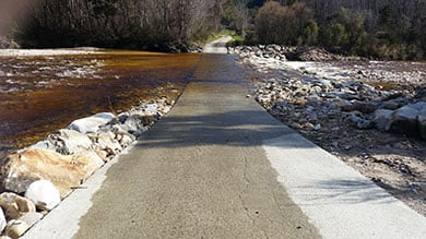
Caution required on Dart River Ford on the Wangapeka River

Dart Ford
Image: Ivan Rogers | DOC
If you’re planning to cross the Dart Ford by vehicle, identify suitable conditions first.
Due to ongoing gravel migration filling the ford, the river is flowing over the ford even at low water levels. The ford may be impassable after heavy rain.
Check river flow for Wangapeka at Walter Peak on the Tasman District Council website before you set off.
As a guide, if the flow indicated on the graph exceeds 40 cumecs then it is not advisable to cross. However, the river may still be unsafe to cross because:
- the flow shown on the website can be inaccurate, or
- the Dart River may be flowing higher than the Wangapeka indicates, or
- the culverts under the ford may be choked with gravel.
So you must re-assess the flow conditions once you arrive in terms of your vehicle and driving skill level. Don’t forget to check the weather forecast for your return trip too.
Experience required
The Karamea Valley is for experienced trampers only. Trampers should be well equipped, fit and self-sufficient. Be prepared with warm, waterproof clothing and extra food.
Rivers can rise and fall very quickly and should not be crossed when swollen. In normal flows unbridged creeks and streams (particularly Mars, Apollo and Kendall Creeks) are easily crossed. However, in flood they can become impassable – you will need to be prepared to wait until floodwaters recede.
Stay safe when crossing rivers
If you plan to cross unbridged rivers, know how to cross safely and be prepared for if you cannot cross.
Do not cross if the river is flooded, you cannot find safe entry and exit points or are unsure it’s safe. Turn back or wait for the river to drop. If in doubt, stay out.
Hazards
Wasps are a known hazard in the area and are particularly common from December to April. Carry antihistamine if you are alergic to their stings.
Things to remember
- Water – we recommend you boil, filter or treat drinking water collected in this area.
- Weather – check the weather forecast before you go.
- Environmental care – minimise impact on the environment by using a portable cooker. Use only dead wood in fireplaces at huts.
- Rubbish – there are no rubbish facilities in the backcountry. Carry out your own rubbish.
Remember – safety is your responsibility.
A feathered treasure of this area is the rare whio/blue duck. They survive by feeding on aquatic insects found in fast-flowing, clear mountain streams and rivers. Kea, kaka and kakariki/NZ parakeet are typical birds of the beech forests of the upper Karamea River.
Thor Hut is the last remaining New Zealand Forest Service hut in the Upper Karamea.
Stay safe in the outdoors
- Choose the right trip for you. Learn about the route and make sure you have the skills for it.
- Understand the weather. Check weather forecasts.
- Pack warm clothes and extra food. Check gear lists.
- Share your plans and take ways to get help. Share directly or use the Outdoor Intentions form or Plan My Walk. Take a distress beacon.
- Take care of yourself and each other.
Whakatū/Nelson Visitor Centre
| Phone: | +64 3 546 9339 |
| Email: | nelsonvc@doc.govt.nz |
| Address: | Millers Acre/Taha o te Awa 1/37 Halifax Street Nelson 7010 |
| Hours: | Visitor centre hours and services |
