8 km one way
Chummies Track begins by fording Wangapeka River, before climbing the hillside on the opposite bank. Note: there is no bridge and the river is impasable if running high.
The track then gains 500 m elevation in a little over a kilometre, climbing to the crest of the ridge. Once on the ridge the climb continues, though the gradient eases and some openings provide views to Mt Baldy and Mt Gomorrah on the Arthur Range to the north.
At the tree line, the track sidles the mountainside through tussock and mountain flax, crossing several small streams, before reaching John Reid Hut.
It is possible to combine Chummies Track and John Reid Hut with Kiwi Track to do a 3-day loop track.
Chummies Track begins near the start of the Wangapeka Track, in the Wangapeka Valley, southwest of Nelson.
From Tapawera, cross the Motueka River and head southwest along Tadmor Valley Rd, then turn right onto Tadmor-Bushend Rd. From Matariki the road is unsealed. Follow the road to the Dart River Ford; this cannot be crossed when running high.
Continue for a further 7 km to the Kahurangi National Park boundary, where a grassed area allows parking and an information panel provides a map and track details. This is where Chummies Track starts.
Caution required on Dart River Ford on the Wangapeka River
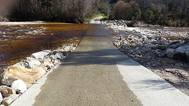
Dart Ford
Image: Ivan Rogers | DOC
If you’re planning to cross the Dart Ford by vehicle, identify suitable conditions first.
Due to ongoing gravel migration filling the ford, the river is flowing over the ford even at low water levels. The ford may be impassable after heavy rain.
We recommend the use of a 4WD vehicle to safely negotiate the ford.
Check river flow for Wangapeka at Walter Peak on the Tasman District Council website before you set off.
As a guide, if the flow indicated on the graph exceeds 40 cumecs then it is not advisable to cross. However, the river may still be unsafe to cross because:
- the flow shown on the website can be inaccurate, or
- the Dart River may be flowing higher than the Wangapeka indicates, or
- the culverts under the ford may be choked with gravel.
So you must re-assess the flow conditions once you arrive in terms of your vehicle and driving skill level. Don’t forget to check the weather forecast for your return trip too.
Chummies Track fords the Wangapeka River which is impassable if running high.
It is located in an alpine environment, so proper preparation and care should be made to ensure a safe trip. Always be prepared for freezing conditions and take extra care if snow and ice and are present.
Make sure you carry plenty of water with you as there are no water sources on the way up.
Stay safe when crossing rivers
If you plan to cross unbridged rivers, know how to cross safely and be prepared for if you cannot cross.
Do not cross if the river is flooded, you cannot find safe entry and exit points or are unsure it’s safe. Turn back or wait for the river to drop. If in doubt, stay out.
NIWA river flow forecasts: View a video of national followed by regional river flows
Stay safe in the outdoors
- Choose the right trip for you. Learn about the route and make sure you have the skills for it.
- Understand the weather. Check weather forecasts.
- Pack warm clothes and extra food. Check gear lists.
- Share your plans and take ways to get help. Leave your intentions with a trusted contact and take a distress beacon.
- Take care of yourself and each other.
Nelson/Tasman/Marlborough information
| Phone: | +64 3 546 9339 |
| Email: | nelsonvc@doc.govt.nz |
| About: | Whakatū/Nelson visitor services provide information for this area |