This challenging tramping route (88 km) is a real adventure for those with a high level of skill and experience (see notes in Know before you go, below).
The route traverses parts of Fiordland and Mount Aspiring National Parks, and Pyke Forest, which are included in the Te Wähipounamu - South West New Zealand World Heritage Area.
Hollyford Road end to Lake Alabaster Hut via the Hollyford Track
5 - 7 hr, 20 km
For details see Hollyford Track.
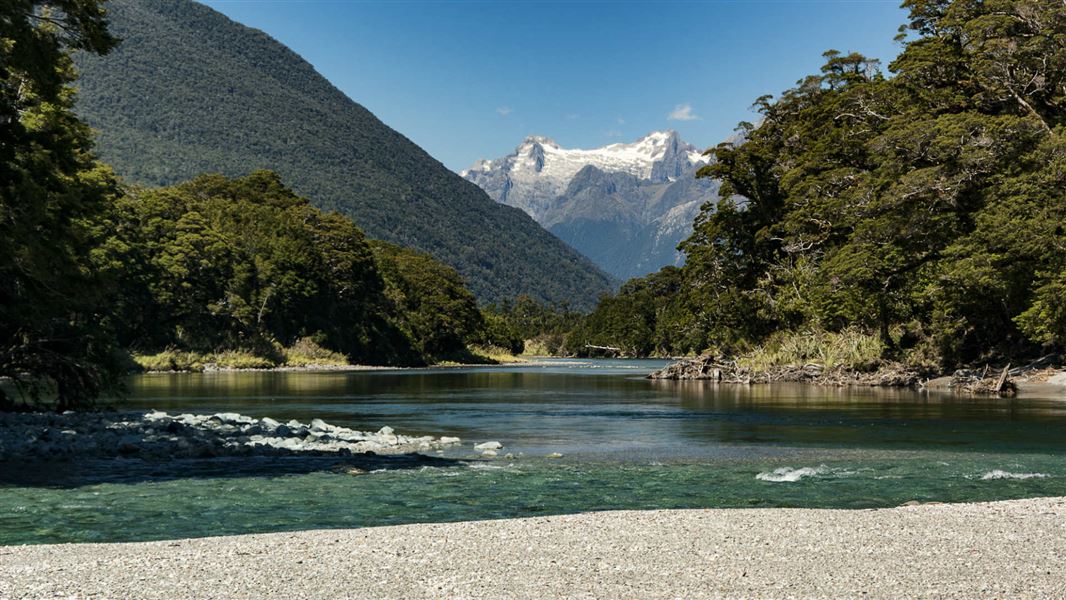
Lake Alabaster Hut to Olivine Hut
7 - 10 hr, 16 km
From Lake Alabaster Hut, follow the lake shore to Alabaster Creek at the head of the lake (2 - 4 hours).
Note that you will encounter knee deep water towards the Alabaster Creek end of the lake during normal lake levels. After rain this becomes very difficult and slow travel. Alabaster Creek is normally crossed via a gravel bar at its mouth. However, after rain this becomes a deep and dangerous crossing. From the head of the lake follow the orange, triangular pole markers through the open areas of flax and tussock until a marked route enters the forest.
The route goes through aptly named ‘Black Swamp’, then follows an overgrown track up the true left of the Pyke River, through beech forest, flax wetlands and river flats to the Olivine Hut (12 bunks).
Olivine Hut to Pyke Crossing
6 - 9 hr, 21 km
Use the cableway to cross the Olivine River. See guidance on using the cableway under 'Know before you go'.
The route follows the old stock route which, though marked, can be difficult to follow due to overgrown vegetation. Open areas of flax and tussock wetlands are encountered between the Diorite and Barrier Rivers.
Both rivers are unbridged and can be impassable after rain. The route continues through tall beech forest to Lake Wilmot. Travel round the lake is difficult, especially if the water level is high.
From here the route continues through beech forest, flax flats and along the river to the Pyke Airstrip and the Pyke Crossing. Markers in the area can get damaged due to flooding, making the route difficult to follow. There are good areas to camp here.
Pyke Crossing to Big Bay Hut
3 - 5 hr, 15 km
A crossing of the Pyke River can normally be made just downstream from Paulin Creek. However, after rain it becomes impassable.
The route follows Paulin Creek and through the forest to the dry Awarua River, where an old prospecting road leads to the mouth of the river at Big Bay. In normal conditions this can be crossed at low tide, otherwise follow a track 15 minutes upstream to a swing bridge.
Big Bay Hut (9 bunks) is at the southern end of the village area. Please respect the private dwellings located here.
Big Bay Hut to Martins Bay Hut
4 - 5 hr, 16 km
This section initially follows the sandy beach from Big Bay to McKenzie Creek, located at the southern end of the bay.
After crossing the creek (take care as McKenzie Creek can often be impassable and extremely dangerous after rain), a short track leads to the coast.
Follow the coastline to Long Reef, before joining the track to Martins Bay Hut (24 bunks) and the Hollyford Track.
The route between Martins Bay Hut and Big Bay Hut near Long Reef is overgrown and has a small slip on it making it difficult to navigate. It's recommended that trampers walk around the coast, but this can only be done 2 hours either side of low tide and with calm sea conditions. Be aware there may be seals in this area.
The Hollyford Track then follows the true right of the Hollyford River/Whakatipu Kä Tuka, and after about an hour’s walk, reaches private dwellings and two airstrips.
Martins Bay Hut to Hollyford Road End (via Hollyford Track)
4 days, 56 km
For details see Hollyford Track.
This track starts either on the first part of the Hollyford Track (end of the Hollyford Road), or at Big Bay on the West Coast.
To get to the Hollyford Road from Te Anau, turn off from the Milford Road (State Highway 94) at Marian Corner, a few minutes towards Milford Sound from The Divide. Marian Corner is about 87 km along the Milford Road from Te Anau. Allow 2 hours to drive from Te Anau to the end of the Hollyford Road.
To get to Big Bay you can either walk along the Hollyford Track, or access this area by light aircraft.
Map
Topo50 series CA09 Alabaster Pass covers this area and is available for purchase from the Fiordland National Park Visitor Centre.
The route near Lake Wilmot does not follow the alignment on the NZTopo map CA09 (printed before 2017). Visit NZ Topo Map or contact the Fiordland National Park Visitor Centre for information on the realignment.
Safety information
This is a challenging tramping route so you will need above average fitness and high level backcountry (remote areas) skills and experience, including navigation and survival skills. You also need river crossing skills and experience.
You need to be well equipped including at least 2 extra days of food in case you are delayed due to weather or flooding. Taking a Personal Locator Beacon and/or mountain radio is essential.
The track is not well defined in places. Some sections flood regularly, making travel impossible for days at a time. Even in good conditions there are several unbridged rivers to cross. Route times are highly variable depending on tramper fitness and ability and weather conditions.
The first section of the route out to Long Reef is very over grown. Trampers can walk down the coast via the formed track to the Point and then follow the beach back towards Big Bay. It is recommended to avoid walking the beach during hightide and up to two hours either side of high tide.
Barrier, Diorite and Pyke Crossing Rivers can be un-crossable even in a medium rain event.
Stay safe when crossing rivers and streams
If you plan to cross unbridged rivers or side streams, know how to cross safely and be prepared for if you cannot cross.
Do not cross if the river or stream is flooded, you cannot find safe entry and exit points or are unsure it’s safe. Turn back or wait for the river to drop. If in doubt, stay out.
NIWA river flow forecasts: View a video of national followed by regional river flows
Using the cableway
A cableway is used to cross rivers on this trip. Take time to read the on-site instructions and familiarise yourself with the operation of the cableway before crossing
Use of this cableway carries risks, so follow the operating instructions carefully.
It is recommended that you do not use this cableway unless part of a larger party or carrying a personal locator beacon (PLB).
Never place your hands on main cable, and keep hands, clothing and long hair clear of all wheels.
In the event of an emergency where the carriage becomes stuck, remain where you are and activate your PLB or have your party seek help.
Stay safe in the outdoors
- Choose the right trip for you. Learn about the route and make sure you have the skills for it.
- Understand the weather. Check weather forecasts.
- Pack warm clothes and extra food. Check gear lists.
- Share your plans and take ways to get help. Leave your intentions with a trusted contact and take a distress beacon.
- Take care of yourself and each other.
Te Rua-o-te-moko/Fiordland National Park Visitor Centre
| Phone: | +64 3 249 7924 |
| Email: | fiordlandvc@doc.govt.nz |
| Address: | 1 Lakefront Drive Te Anau 9600 |
| Hours: | Visitor centre hours and services |