Heritage
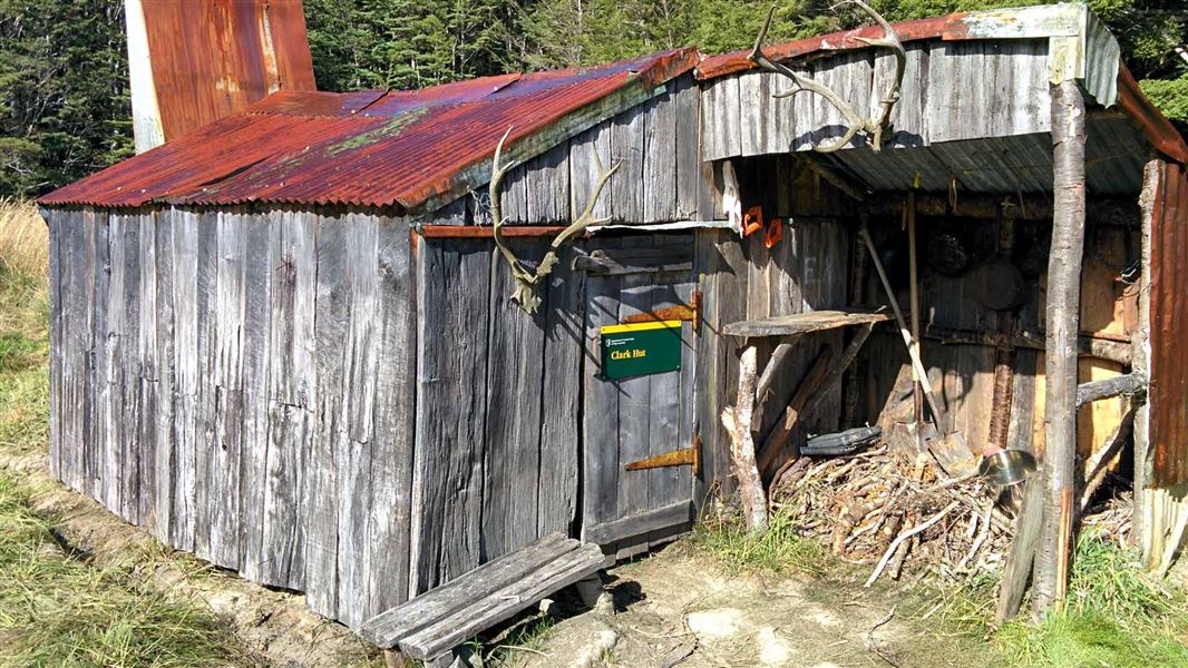
Clark Hut is the last remaining split beech log hut and one of two remaining deer culler’s huts in Fiordland National Park. The hut receives continual use by hunters and trampers. The liberation of deer into New Zealand’s forests had a dramatic effect on the flora and fauna. In the 1920s the Department of Internal Affairs (DIA) began a culling program to eradicate the ‘deer menace’.
The operation was placed in the hands of Graham “Skipper” Yerex who ran the operation for 25 years. Teams of hunters were sent into the back blocks to cull deer, and numerous small huts were built to house the men. The hut provides the visitor with an insight into the work, living conditions and lifestyle of the deer culler of the 1940s.
The four bunk Clark Hut was built in 1941 by cullers Archie Clark and Allan Cookson, with funding from the DIA. All wood for the hut was cut from the surrounding forest, and any equipment was brought in via Lake Monowai on a clinker dinghy, and then tramped in to the site. The hut became a base for hunting in the area of Green Lake, Jaquiery River, Florence River, and Fowler Stream.
Archie Clark, the first deer culler in the area, was a local legend, an expert stalker and a crack shot. In Hunting in New Zealand Rex Forrester says of Archie "One of the old-time Government hunters, Archie Clark averaged out a bullet and a half for the many thousands of deer he shot through the years. There is no doubt he must have been a crack shot, but I have heard fellers who knew him well say that he did it by expert stalking."
Hut description
The hut is set in the upper Grebe Valley in an open tussock clearing. It is 3.2 metre by 3.8 metre with beech sapling framing, split beech cladding, a wooden floor, on broadleaf piles. There is a stone fireplace, flat iron chimney, and corrugated iron roof. It also has a lean-to wood shed which was added later. Internal fittings and furniture such as bunks are also made of pole beech. The original door was constructed from sawn rimu but has been replaced. There is a window in the west wall.
A few yarns
Deer culler William Deer was based at Clark Hut in 1947 when a Proctor Percival aeroplane crashed at the mouth of Jaquiery River. Deer walked out to Monowai to get assistance, but this came too late to save the passenger and pilot.
Over the summer of 1966-7 the hut was used by Forest Service research for a red deer culling programme under scientist Graeme Caughley. The first lot of supplies for this operation were dropped into Clark Hut by Bill Black in a De Havilland Dominie on 11 October 1966. Jim Kane had just started meat shooting from Clark Hut, taking carcasses out to Lake Monowai by horse and then down the lake. He was most disconcerted when the Forest Service supplies began to rain down unexpectedly, followed shortly afterward by the Forest Service hunters on foot. Forest Service hunting was focussed further afield in the Florence and Jaquiery, but must have had some impact on the deer available to him.
The second drop for the Forest Service hunters was made on 7 January 1967 and was no less of a surprise! One of the hunters recalls that Jim Kane was in the hut sleeping off a night’s spotlighting when he was woken by the roar of the Dominie. Staggering to the door he was almost bowled over by the first sack, which entered the hut door, shot across the floor, and tipped up his camp oven of stew from above the fire. The second run put a sack of food (including tins and potatoes) onto the hut roof leaving a dent that still remains.
Another tale has it that a later culler, Lindsay Dickson, had complained about how far away supplies were dropped for him. The next time pilot Bill Hewitt dropped the supplies in by plane the bag of flour dented the roof, and the chimney was destroyed by a box of ammunition. The chimney was reputably repaired with the engine cowling of the wrecked Proctor Percival plane.
Fees
Free
Clark Hut can only be accessed by tramping, either from Lake Monowai Road, or from the end of Lake Monowai.
Tracks to this hut
-
Duration: 9 hr one way Difficulty: Advanced
Location
NZTopo50 map sheet: CE07
Grid/NZTM2000 coordinates: E1158401, N4914168
Te Rua-o-te-moko/Fiordland National Park Visitor Centre
| Phone: | +64 3 249 7924 |
| Email: | fiordlandvc@doc.govt.nz |
| Address: | Lakefront Drive Te Anau 9600 |
| Hours: | Visitor centre hours and services |
