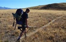
Tenahaun hunting
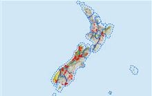
Located in Mid & South Canterbury hunting in the Canterbury region
|
Introduction
Tenahaun area forms part of the Moorhouse Range, which is just north of the Rangitata River gorge. Hunt for chamois, red deer and pig.Species
- Chamois
- Deer - Red
- Pigs
Permit requirements
This hunting area is covered by an 'open area permit' – get it online or from a DOC office.
Dog access
About this hunting block
General information
This area is mainly low mountainous terrain. The highest point is Mt Tripp at 1368 m. The vegetation is tussock with thick scrubland communities in most gullies.
Access
From Mayfield follow Hinds Gorge Road and turn off on to Chapmans Road. Alternatively, follow Ealing Montalto Road until the turn off for Klondyke Terrace. This road continues to the Rangitata Diversion Race intake at the Rangitata River.
Signs mark the public access points. Access is by foot or mountain bike – there is no access for motor vehicles. Keep to the marked tracks across private land.
Helicopter landings will not be approved.
Topo maps
NZTopo50 map sheet: BX19 Hakatere
Dogs
Dogs are not permitted on the public easements.
Dogs are permitted on public conservation land but dog access to it needs to be granted by the landowner.
Hut information
There are no huts and bivvies in this area.
Additional information
Check for current pesticide operations that may be in progress where you intend to hunt.
Contacts
| Raukapuka / Geraldine Office | |
| Phone: | 0800 275 362 |
| Email: | info@doc.govt.nz |
| Address: |
13 – 15 North Terrace Geraldine 7930 |
| Postal Address: |
PO Box 33 Geraldine 7956 |
| Full office details | |