This track is part of the Remutaka Cycle Trail (Ngā Haerenga New Zealand Cycle Trails).
16.5 km one way
There is an active landslide on this track. Detour may not be accessible at high tide and during rough seas. Avoid the area during or after heavy rainfall due to flooding, landslide and rockfall risks.
Image gallery
This track is managed in partnership with Find your Wild. Wellington Regional Trials – Remutaka Cycle Trail has information about distances and points of interest.
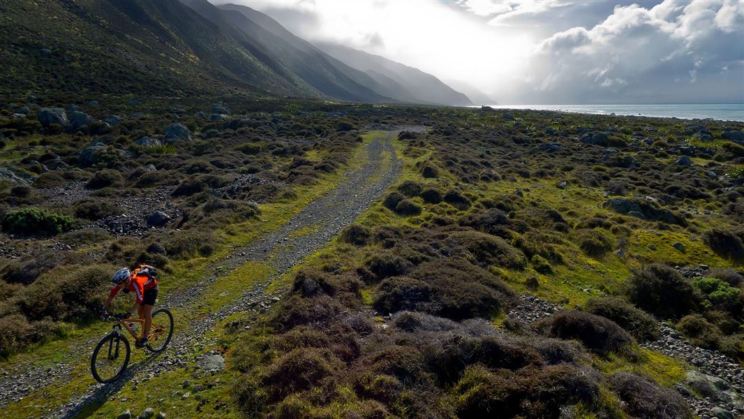
This track contains some of the most remote and spectacular scenery of the 115 km Remutaka Cycle Trail loop. The track can be ridden or walked in either direction and has no significant climbs. There are multiple sections that will be easier to carry your bike rather than ride.
We recommend avoiding this area during and after heavy rain, as that increases the risk of rockfalls, landslides and flooding. Check the weather forecast.
The Wild Coast Track is mostly road and is well marked when it leaves the road. The track covers many different environments including:
- streams which will require crossing – they can flood and become impassable
- unsealed roads
- dunes
- shingle areas.
There are spots for camping, a picnic area with water, and a toilet on the track.
Detailed description
This description covers the track from the campsite at Corner Creek in the Wairarapa to the ending at the Wainuiomata Coast Road.
From the campsite at Corner Creek, start the Wild Coast Track by following the unsealed coastal road. The old road will pass through an open gate and from here the track enters private land at the Mukamuka Stream valley.
This is the first and largest of the stream crossings. Assess all the stream crossings carefully and if in doubt, do not cross. The streams along this track can flood and become impassable.
The track will leave the road and come to a picnic and camping area. The track then crosses through shifting dunes. You'll then come to a second stream the which you'll need to ford. There are informal camping spots on the terraces next to this stream. This is the last opportunity for camping before the end of the Wild Coast Track.
You'll need to go through a large metal gate as you enter the Ōrongorongo Station.
The track then crosses three streams at the Kotumu Fan. This part of the track may have numerous washouts and require you to walk your bicycle for up to 1 km.
Continuing on the track, you'll pass Barny's Whare, a private bookable hut. At a marked junction, the track leaves the main farm track and heads towards the coast and a seal colony.
The track continues to the main entry and exit gate at the Ōrongorongo River, where there is a car park and toilet. Beyond this point is the Wainuiomata Coast Road. The main gate is a narrow metal squeeze gate designed to keep motorbikes out.
From Wellington, travel to the end of the Wainuiomata Coast Road.
From the Wairarapa, the track begins at Ocean Beach at Corner Creek.
Plan your trip using tide timetables and weather and marine forecasts
The beach detour around the active landslide near Corner Creek may not be accessible at high tides and rough seas. There are greater risks from rockfalls, flooding and landslides during and after heavy rain.
We recommend you plan your trip so you are passing this section of track at low tide and during calm seas and dry weather. Check the:
Skills/experience needed for biking the track
This is an Advanced: Grade 4 bike trail and will suit fit, experienced cyclists. You need the strength/fitness to lift your bike over obstacles and carry it for sections, ride into strong wind, and cycle over rocky and sandy terrain.
Walking the track is a good alternative or biking another section of the Remutaka Cycle Trail.
There are unbridged stream crossings on this track which can flood and become impassable. You need the skills to know how to cross a stream safely and to recognise when it is unsafe to cross.
Washed out sections
Several sections of the track are passable but unrideable due to washouts. Keep away from washed out track edges as there is a risk of falling. Allow additional time for your journey.
There are rockfall and landslide risks on this track
There are ongoing rockfall and landslide risks. While the risk is highest during and after heavy rain, it is still present in good weather.
Preparing for the trip
The area has little or no shelter from the weather, especially from the south. Check the forecast and pack plenty of warm, waterproof clothes.
Cell phone coverage is good but there are patches of poor reception. As the area is remote, consider packing a distress beacon.
If riding, you need a mountain bike in good condition. Take spare parts for the bike and a first aid kit.
Stay safe when crossing rivers and streams
If you plan to cross unbridged rivers or side streams, know how to cross safely and be prepared for if you cannot cross.
Do not cross if the river or stream is flooded, you cannot find safe entry and exit points or are unsure it’s safe. Turn back or wait for the river to drop. If in doubt, stay out.
NIWA river flow forecasts: View a video of national followed by regional river flows
Be aware of seals and farm operations
The track crosses working farms where stock and farm vehicles may be present. Keep to the track.
Stay 20 m away from seals.
Stay safe in the outdoors
- Choose the right trip for you. Learn about the route and make sure you have the skills for it.
- Understand the weather. Check weather forecasts.
- Pack warm clothes and extra food. Check gear lists.
- Share your plans and take ways to get help. Leave your intentions with a trusted contact and take a distress beacon.
- Take care of yourself and each other.
Wellington/Kapiti information
| Phone: | +64 3 546 9339 |
| Email: | nelsonvc@doc.govt.nz |
| About: | Whakatū/Nelson visitor services provide information for this area |