24 km loop
This track can be walked in either direction. This description details a clockwise circuit of the track. Times are based on walking at 2 km/hour. The track can be completed as an overnight trip or extended to two nights by staying at both huts.
Silverpeaks Scenic Reserve car park to Jubilee Hut
Time 4.5 hours
Distance: 9 km
Start the circuit track from the Silverpeaks Scenic Reserve car park. Take the left fork to follow the track in a clockwise direction. The track climbs steadily for an hour where you will reach a grass clearing with bench seats. The seats have been installed at the site of the former Green Hut and recognise the Otago Tramping and Mountaineering Club and the Green Hut Track Group. The Green Hut Track Group are a volunteer group who maintain the backcountry tracks in Dunedin.
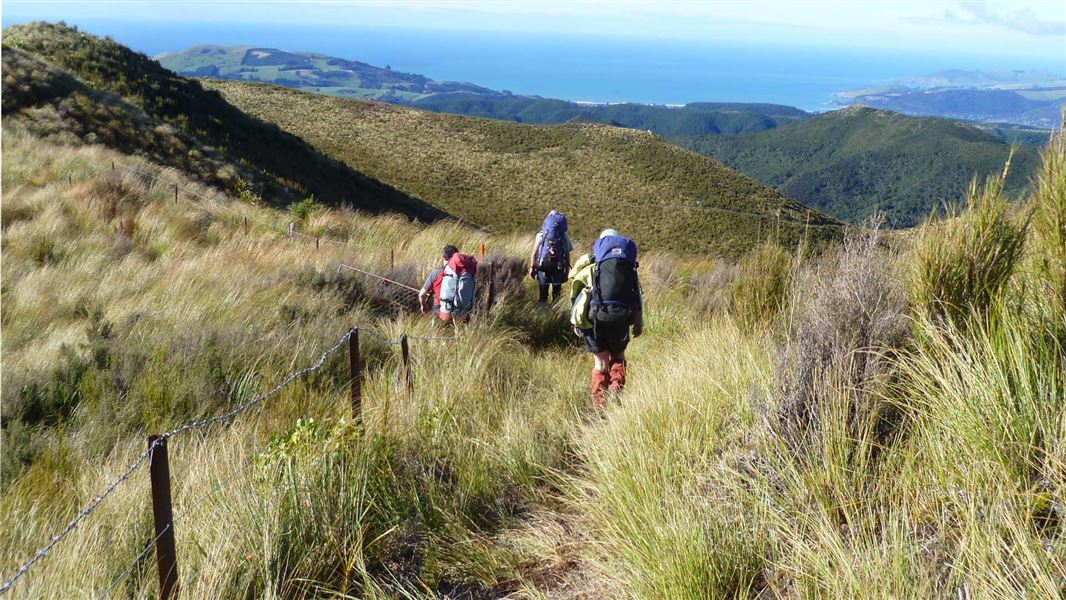
From here, the climb continues and you will reach Pulpit Rock for panoramic views of the Dunedin area and coastline. From Pulpit Rock and along the ridgeline you can view the Painted Forest, a significant stand of silver beech/tawhai. This area is very exposed and weather conditions can change suddenly – Māori named this section Paekohu, or ‘fog ridge’, for good reason.
The track then descends into a schist-tor encrusted upland valley. After passing a prominent schist tor or obelisk, turn left to look down a steep ridge into the valley. At this point you can see Jubilee Hut in the distance, up on the valley’s left flank. Reaching it means negotiating the aptly named Devils Staircase, an unbenched, steep 340 m descent to the valley floor. Take extreme care.
Once you are on the valley floor the track continues for another 700 m, crossing the creek several times before you reach an intersection to Jubilee Hut. The final walk up to Jubilee Hut is a steep 10 min climb.
Jubilee Hut to Philip J Cox Memorial Hut
Time: 3 hr 50 min
Distance: 7.7 km
From the hut you must return down the track to rejoin the Silverpeaks Circuit Track. You will immediately cross a creek and climb steeply up a face to the next ridgeline. From here the track follows an old 4WD road across the ridgeline before dropping towards the valley floor beneath a large rock formation known locally as 'The Cats Teeth'.
Underneath the Cats Teeth, approximately 2.5 km from Jubilee Hut, you will find an intersection marking the side trip to ABC Cave - see below.
From the intersection with ABC Cave the track continues along the valley floor before climbing back up to meet Yellow Ridge. From the top of Yellow Ridge, the track descends through tussock and into regenerating native bush before reaching Philip J Cox Memorial Hut.
Camping is not available at the hut. The grass area beside it is for helicopter landings and should not be camped on in case of emergency helicopter landings.
Philip J Cox Memorial Hut to Silverpeaks Scenic Reserve car park
Time: 3 hr 45 min
Distance: 7.5 km
From Philip J Cox Memorial Hut the track continues down the ridge through native bush. 400 m from the hut, a new track alignment has been adopted to form a complete circuit within the Silverpeaks Scenic Reserve. Instead of following the old track alignment which exited the reserve via a forestry block, turn right at wooden routed sign named River Track. Continue to follow the wooden routed River Track signs to stay on the new track to complete the circuit and return to the Silverpeaks Scenic Reserve car park.
The track follows the South Branch of the Waikouaiti River which you must cross a couple of times. If you keep an eye out, you will be able to see former gold mine workings and water races as well as a beautiful rock pool which is a must see part of the track.
This section of track provides a steady gradient most of the way before reaching a final steep climb from the valley floor back to the car park.
Side trips
ABC Cave Route
Time: 10 min
Distance: 60 m return
ABC Cave is a small cave named after three your Dunedin men, Al, Bruce and Colin who often used the cave in the late 1960s. It has a timber sleeping platform and can be used as a shelter. Turn right at the marked intersection, approximately 2.5 km from Jubilee Hut, and walk up the narrow, steep route for 5 minutes to reach the cave.
Note: ABC Cave is not marked correctly on the NZ Topo Map. The route to the cave starts 250 m south of the marked location on the NZ Topo Map.
Possum Hut Route
Time: 30 min
Distance: 900 m return
This route takes you to the historic Possum Hut. The hut is derelict and should not be entered or used as accommodation. The hut was constructed by Joe Clark and Philip Powell (neighbouring farmers), it is assumed in the depression years of the 1930s. They dug a water race and mined for gold in the Waikouaiti River.
From Dunedin, head north on SH1. Just past the Waitati Store at Blueskin Bay, turn left onto Double Hill Road, and follow the gravel road up the hill. The road transitions from Double Hill Road to Semple Road, to Steep Hill Road.
The Silverpeaks Scenic Reserve car park provides access to the Silverpeaks Circuit Track and Swampy Ridge Route. The car park is a small pull off on the side of the gravel road with a sign marking the entrance to the track.
Logging trucks use this road frequently, keep to the left, drive with your headlights on and drive to the conditions.
Challenging conditions with rapidly changing weather
Although the Silverpeaks aren’t high by some standards, this is exposed, rugged, challenging country, with weather conditions that can change rapidly. It is often both fogged in and blasted by south-westerly storms or chilled by the prevailing nor-easterly.
A good standard of fitness, equipment and experience is necessary.
The track crosses creeks and rivers. Flash flooding can occur during periods of high rainfall. Avoid the area during or immediately after periods of heavy rain.
No fires
Fires are not permitted in the Silverpeaks at any time. Fire could destroy this special place in a matter of hours. Fires put you and others at risk.
Other routes off this track
ABC Cave is not marked correctly on the NZ Topo Map. The route to the cave starts 250m south of the marked location on the NZ Topo Map.
There are other routes off this track. Follow the DOC marked tracks only. Unmarked routes are not managed by DOC or maintained.
The wooden routed signs named River Track mark the new alignment for the Silverpeaks Circuit Track. These signs will be replaced by DOC intersection signs, until then, these signs mark the DOC track.
Be aware that the track alignment on the DOC website was updated in August 2024. Paper maps, mapping apps and third-party websites may not show the correct track alignment if they have not been updated.
Stay safe when crossing rivers and streams
If you plan to cross unbridged rivers or side streams, know how to cross safely and be prepared for if you cannot cross.
Do not cross if the river or stream is flooded, you cannot find safe entry and exit points or are unsure it’s safe. Turn back or wait for the river to drop. If in doubt, stay out.
NIWA river flow forecasts: View a video of national followed by regional river flows
Stay safe in the outdoors
- Choose the right trip for you. Learn about the route and make sure you have the skills for it.
- Understand the weather. Check weather forecasts.
- Pack warm clothes and extra food. Check gear lists.
- Share your plans and take ways to get help. Leave your intentions with a trusted contact and take a distress beacon.
- Take care of yourself and each other.
DOC Customer Service Centre
| Phone: | 0800 275 362 |
| Email: | dunedinoffice@doc.govt.nz |
| Address: | Ōtepoti / Dunedin Office |