Image gallery
This track is part of Te Araroa Trail.
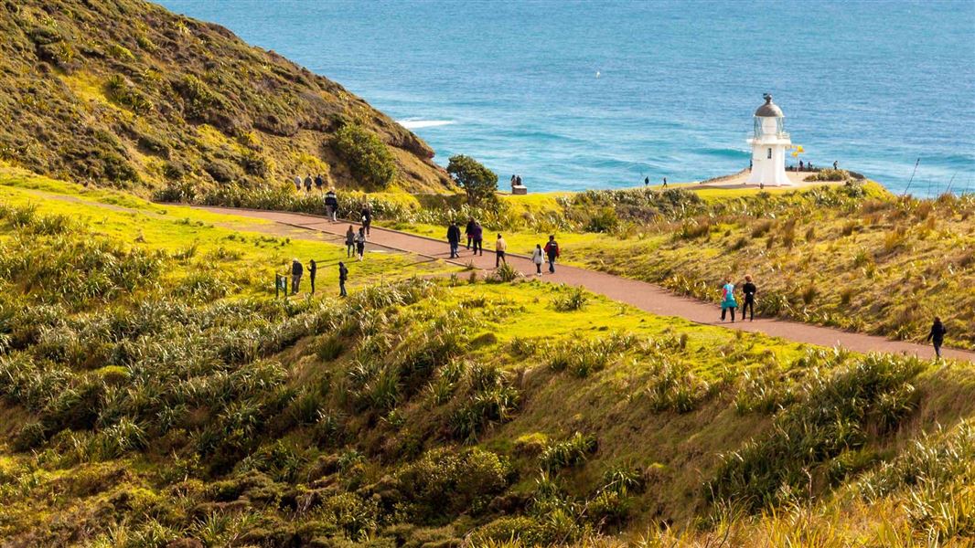
Walk a short distance from the carpark to the lighthouse to experience outstanding views of the Northern Coast. The track may not be suitable for all wheelchair users because it has steep sections.
Barriers are installed on the lighthouse track to prevent unwanted access by motorised vehicles. Be aware the gap between the bollards is 860 mm with a need to turn at a right angle. This might affect some wheelchair access. If you require access, contact Ngāti Kuri Facilities Services Helpdesk by phoning 0800 TE PAKI (0800 837 254) or emailing campgrounds@ngatikuri.iwi.nz.
To the west Cape Maria Van Dieman and Motuopao Island, to the east is Piwhane/Spirits Bay and Hikurua/de Serville Cliffs, the North Island's most northern point.
Offshore, you can witness the immense power of two mighty oceans merging. The currents of the Tasman Sea and the Pacific Ocean meet in a foaming swell of broken water over the Columbia Bank. At times, the churning waves erupt in explosions of spray and spume. On a clear day you might be lucky enough to see the Three Kings Islands on the distant horizon.
Cape Reinga/Te Rerenga Wairua is located at the northernmost area of New Zealand, approximately 111 km north of Kaitaia.
Follow State Highway 1 north to Waitiki Landing, continuing another 20 km to Cape Reinga/Te Rerenga Wairua.
Cape Reinga Road gets very busy over the summer months. Drive slowly and take extra caution.
Cultural protocol for visiting Cape Reinga/Te Rerenga
Cape Reinga/Te Rerenga Wairua is a highly significant place for Māori. There are tikanga (cultural protocols) for visiting here. Please do not eat any food at Cape Reinga/Te Rerenga Wairua. It is fine to drink water.
If you wish to eat, Tapotupotu is a nice alternative. It is 5-10 min drive on a gravel road, with toilets available.
People sometimes wish to bury or scatter the ashes of their loved ones at Cape Reinga/Te Rerenga Wairua. As the cape is a sacred site, this is not culturally appropriate. It is a lovely place to remember people who have passed, but please do not bury or scatter any ashes here.
No camping is permitted
No camping is allowed at Cape Reinga/Te Rerenga Wairua. The nearest campground is at Tapotupotu and is managed by local Iwi Ngāti Kuri. Bookings are required at Tapotupotu Campsite – read about the campsite and make a booking here.
Stay on the track, leave pets at home, and take your rubbish with you
There are no rubbish bins at Cape Reinga/Te Rerenga Wairua, so take all rubbish away with you. No pets are allowed, including no dogs.
The area around the lighthouse and track has steep drop-offs, stay on the paved track and viewing area at all times and mind children.
Visit off-peak for a quieter experience
Cape Reinga/Te Rerenga Wairua gets very busy in late December-early January and in the middle of the day (11 am-3 pm). If you wish to explore the area with fewer other visitors present, we recommend visiting in the early morning or late afternoon. Gates are closed to the car park between 8.30pm and 7am.
Weather forecast
Be ready for windy weather – the cape is very exposed, the weather changes fast and strong wind is common.
Cape Reinga/Te Rerenga Wairua weather forecast – NIWA website
Stop kauri disease and protect kauri
- Scrub all soil off shoes and gear.
- Use cleaning stations.
- Always stay on the track.
DOC Customer Service Centre
| Phone: | 0800 275 362 |
| Email: | kaitaia@doc.govt.nz |
| Address: | Te Hiku / Kaitaia Office |