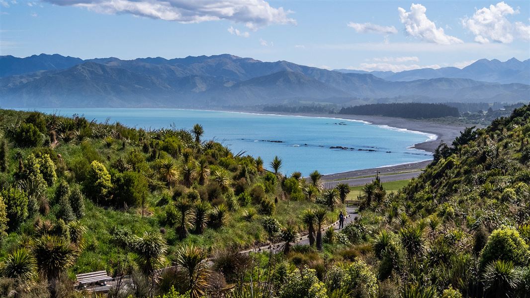
- The walkway juts from the rugged east coast of the South Island, with a backdrop of steep mountains, snow-capped in winter.
- The area's wildlife includes whales, dolphins, seals, birds and crayfish.
- An impressive collection of information panels along the walkway explains the rich history, geology, animals and plants that make the area so special.
Various: 200 m – 11.7 km one way
Image gallery
This is a Tohu Whenua heritage site. Located in stunning landscapes and rich with stories, these sites offer some of our best heritage experiences.
The track crosses the peninsula’s clifftop, with excellent views of the Seaward Kaikōura Range, ocean and coastline, to South Bay. It returns to the township via South Bay and Toms Track.
This track has exposed unfenced cliff edges. Stay on the formed track and supervise children at all times.
To fully explore and enjoy the features of the walk, allow at least three hours to complete the whole walkway.
Kaikōura town centre to Point Kean car park
Time: 50 min
Distance: 4.4 km
From the town centre, follow the footpath and road verge along The Esplanade, Avoca Street and Fyffe Quay to Point Kean. On the way, look out for the interpretation signs on The Esplanade opposite Brighton and Margate Streets, telling stories of 'Life on the edge', a community living by the sea — the land, the sea and the people.
Near Fyffe House, a sign details the early European settlement in Kaikōura. At nearby Armers Beach, the story tells of the importance this site holds for the local community, both past and present, for the shelter it provides.
At Point Kean carpark seals are likely to be present in the surrounding area. Most of the seals in the carpark are males. They may appear to be harmless – however, they are capable of becoming aggressive if disturbed and can inflict a nasty, infectious bite.
What to do if you find a seal.
The seals on the rocky platforms out from the carpark are females and their pups. For your safety and to avoid disturbing the seals, remain atleast 20 m from any seal.
There are toilets at the carpark.
Point Kean car park to Point Kean viewpoint
Time: 5 min
Distance: 200 m
Walk up the hill from the car park to a lookout platform. This platform, designed in the shape of a waka, gives views of both the sea and the mountains. Interpretation panels provide stories of the land, the sea and the people who lived here.
From the carpark when the tide is low, you're able to explore the open tidal platforms. You may see wading birds, such as oystercatchers and reef herons, feeding on the platforms. Shags are common and blue penguins may be seen bobbing just offshore.
Just off the tidal platforms is an excellent diving and snorkelling area for those who want a closer look at the marine life.
Point Kean viewpoint to Whalers Bay viewpoint
Time: 25 min
Distance: 1.5 km
Beyond the lookout platform, follow the track along the clifftop for superb views of rugged cliff formations, tidal platforms and the Seaward Kaikōura Range.
An interpretation panel on this section of the walkway explains that, hundreds of years ago, the peninsula was forested with many species of native New Zealand trees and plants. Most of this vegetation was removed during successive waves of human development, leaving small, remnant outcrops of hardy shrubs and plants clinging to the steep cliff faces.
Whalers Bay side-trip
This track down a stairway follows a former whalers’ route down the cliff to the shoreline. There are extra hazards in this area including potential rockfall and wildlife.
A prominent feature in this area is known as 'the Sugarloaf'. Don't climb this landmark, to prevent further erosion.
View seabirds, seals, walkers, divers, crayfish floats and fishing boats. Out to sea, you may see scores of seabirds feeding frantically on small fish herded to the surface by bigger fish or dolphins.
Take care to avoid disturbing any wildlife along the shoreline as there are large colonies of birds in the area. These are particularly vulnerable to disturbance during the breeding season over summer.
Return back up via the same cliff track, as tides or seals along the shoreline may prevent you from returning to the carpark. The track along shoreline back to carpark is not a DOC maintained track and its use is not recommended for safety reasons.
Interpretation on the clifftop overlooking 'the Sugarloaf' describes the point below as 'Bird City' – the largest red-billed gull colony in the South Island. From here, whalers kept a vigil over the sea, looking out for their quarry. Around the corner in Whalers Bay was the launching point for the whalers’ boats.
Whalers Bay viewpoint to South Bay viewpoint
Time: 20 min
Distance: 1.1 km
On the sea cliffs near this section of the walkway, is a new colony of Hutton’s shearwater behind a large predator-proof fence. In summer you may see large rafts of these birds sitting on the water.
At nightfall, after feeding at sea all day, they return to their breeding colonies high up in the Seaward Kaikōura Ranges. An interpretation panel explains the work being undertaken to establish a colony on the Kaikōura Peninsula.
South Bay viewpoint to South Bay carpark
Time: 15 min
Distance: 600 m
From the South Bay viewpoint, the walkway descends to a fully accessible path that leads to an information shelter and toilets at South Bay. Before descending to South Bay, you can view the tidal platforms and the view south. The interpretation panel here has a landscape profile identifying the mountain peaks and Goose Bay.
South Bay to Kaikōura town centre via Scarborough Street
Time: 1 hr 5 min
Distance: 3.9 km
From the South Bay shelter, return to Kaikōura town centre by following the marker posts along the coast towards the marina. Follow the marker posts to South Bay Parade and cross to South Bay Track, walk up the hill, cross Scarborough Street and walk down Toms Track to return to The Esplanade.
Other options/short walks
South Bay car park to Limestone Bay
Time: 5 min
Distance: 250 m
At South Bay, a fully accessible path from the carpark takes you to Limestone Bay. The elevated walkway above the tidal platform gives wonderful coastal views and allows you to smell the ocean and watch the birds.
Limestone Bay to South Bay viewpoint
Time: 10 min
Distance: 350 m
This climb up to a viewpoint on the clifftop rewards you with superb views of tidal platforms, cliff formations and Haumuri Bluffs to the south.
Getting there
The walkway starts from Kaikōura township. Kaikōura lies almost midway between Picton (154 km) and Christchurch (183 km) off SH1 on the east coast of the South Island. Regular bus and train services pass through the town.
There is no scheduled public transport from Kaikōura to the walkway but you may be able to arrange commercial transport.
Geology
Kaikōura Peninsula is made of limestone and siltstone laid down beneath the sea about 60 million years ago – but it has been exposed to the elements for a mere 180,000 years. Once an island, it is now linked to the mainland by debris eroded from the Kaikōura mountains. These mountains are rising faster than any other mountains in New Zealand (10 mm per year) but erosion keeps their height fairly constant.
Periods of rapid uplift have formed the steep-sided promontories, ideal for pā sites, and have twisted the neatly layered limestone into unusual shapes. The relatively young rocks have been worn into many interesting forms by the pounding sea. In less active periods, the sea has cut large tidal platforms in the softer sandstone.
Offshore is a very deep underwater canyon system called the Hikurangi Trench. It comes unusually close to shore at Kaikōura, where it is known as the Kaikōura Canyon. The canyon floor collects sediments that will form tomorrow’s rocks and may appear in millions of years’ time as new mountains.
Marine life
Jutting out around 4 km from the shore and sculpted by numerous rocky headlands and small, semi-sheltered embayments, the peninsula presents a wide variety of aspects depending on the weather.
Rocky outcrops, wavecut mudstone platforms incised with guts and channels and tortured-looking limestone reefs are interspersed with boulder reefs and small, crescent-shaped, stony beaches. The reefs, so prominent at low tide, continue for hundreds of metres offshore, eventually breaking up into flat expanses of pebbles, which eventually terminate in sand and mud further offshore
The peninsula is a biological nodal point, a place where 'north meets south' or, more accurately, where 'warm meets cold'. Here, the distributions of typically northern and southern species overlap – the seaweeds show a strong southern affinity, while the animals show a warmer, more northern influence. Add to this the rich variety of intertidal and sub-tidal habitats, and you have one of the most biologically diverse locations of the entire east coast of the South Island.
Firmly anchored to the rocks, bull kelp forms a distinctive fringe along the low-tide mark, its dense mass of leathery fronds swirling snake-like in the waves. Kelp and numerous other seaweeds thrive in the pulsating light zone of Kaikōura’s nutrient-rich coastal waters and, along with phytoplankton (microscopic plants), form the beginning of the marine food chain.
Koura (crayfish) shelter in rocky crevices and under boulders around much of the peninsula; these are some of Kaikōura’s best known marine creatures and lend their name to the town. Ranging from barnacles, limpets and crabs to paua, sponges and fish, the multitude of marine animals found at Kaikōura Peninsula is simply remarkable.
Hutton's shearwater colony
This colony, adjacent to the walkway, provides a sanctuary for these unique birds and a special opportunity for visitors to experience the delight of an active sea bird colony, especially at night when the birds return from feeding at sea.
Thee 500 m long, state-of-the-art predator-proof fence keeps out introduced mammals such as rats, cats, possums and stoats as these burrow-nesting birds are particularly vulnerable to predators.
More about Hutton's shearwater/Kaikōura tītī.
Proposed international dark sky sanctuary
This area is renowned for its clear night skies. It’s a perfect spot for stargazing and astrophotography. Due to its position and location, and so little light pollution, you’ll have an amazing view of:
- the Milky Way (Te Ikaroa)
- the Southern Cross
- Large and Small Magellanic Clouds
- the magnificent globular cluster Omega Centauri.
Find out more about the best spots for stargazing in the area and read the proposal to make the area an international dark sky sanctuary at the Kaikōura Dark Sky Trust website.
The name Kaikōura means 'eat crayfish', recalling the occasion when Tama ki te Raki had a meal of crayfish here, pausing on his journey around the South Island in pursuit of his three runaway wives
The peninsula, providing abundant food and shelter, is rich in over 800 years of Māori tradition. The earliest Māori hunted moa and sheltered in coastal caves. A grave found in the 1850s revealed the skeleton of a man holding the largest complete moa egg ever discovered and a pakohe (argillite) adze. As moa numbers declined, gardening became more important and settlements more permanent.
Fortifications were built on hilltops as lookout points and for shelter in case of attack. There are at least fourteen pā sites on the peninsula, most of which were occupied for short periods only and witnessed some fierce battles. Today Ngai Tahu occupy the area at Takahanga Marae in the township.
Both Māori and Pakeha have found Kaikōura ideal for settlement, relying on the bountiful harvest of food from the ocean and the shelter afforded by the peninsula.
The whaling industry attracted the earliest European settlers to the area. Whales occur here because of the unusually deep waters close to shore. Some whales pause in their migration from feeding grounds in Antarctic waters to breeding grounds in the warm sub-tropical seas of the Pacific Ocean, north of New Zealand. Robert Fyffe established the first shore-whaling station, Waiopuka, in 1843; other stations were built soon after in South Bay.
Due to the pressure of the whaling industry, whale numbers steadily declined after 1850 and it became uneconomic to exploit them. Today, with marine mammals in New Zealand being fully protected, the whales again find Kaikōura a safe environment. Kaikōura is now internationally renowned as a whale-watching location.
Fyffe House, standing on piles made from whalebone vertebrae, provides a link with Kaikōura’s whaling days. It was built by George Fyffe in 1860 and is situated on the way to the northern end of the Walkway. The house is a Historic Places Trust property and is open to the public.
For many years, the town’s main link with the outside world was its official port of entry; now, all that remains of the former customhouse is an old brick chimney near Fyffe House. Because the overland routes and bridle tracks were hard-going, most people and freight travelled by sea, often braving inclement weather and the perilous coast, which could take a heavy toll on a small coastal vessel. Eventually, access by land improved and, in 1931, the port closed. In 1945 the Christchurch to Picton railway opened, complete with 21 tunnels.
Like other small towns, Kaikōura suffered from the economic recession of the 1980s. However, since then, an increased number of visitors, attracted mainly by the opportunities provided to observe marine mammals close at hand, has brought increased prosperity to the area.
Fall risk
There is a risk of falling on sections of this track due to cliffs. Keep to the marked track and avoid cliff edges. Keep children within sight and do not let them near edges.
It is dangerous to descend the cliffs on unformed tracks.
Do not trample plants as the cliffs are being revegetated. To descend to the shoreline, use the formed track down to Whalers Bay and return via this same track.
Weather
The peninsula is very exposed to coastal winds. Weather conditions can change quickly, especially when a southerly storm arrives: be prepared with warm and windproof clothing.
Tides
High tide may restrict access along the shoreline.
Wildlife
Many animals and birds make the peninsula their home. Observe wildlife from a distance. If birds start flying at you, this is their way of telling you that you are too close to them.
Report any injured or stressed wildlife to our hotline 0800 DOC HOT (0800 362 468).
Fires
No fires are allowed on the walkway, on the shoreline or in the carparks at Point Kean and South Bay.
Toilets
There are no toilets on the clifftop. Toilets are located at Armers Beach on the way to Point Kean car park and in South Bay.
Private land
Sections of the walkway cross private land. Respect farm property and stock and do not take vehicles, mountain bikes, firearms or dogs on the walkway.
Rubbish
There are no rubbish facilities along the clifftop. Use the rubbish and recycling facilities at the car parks.
Mountain biking
Mountain biking is not permitted on the walkway.
Dogs and other pets
Dogs and other pets are a threat to wildlife. They're not allowed on the tidal platforms or on the walkway except on these sections:
- town centre to Point Kean car park but not in the car park
- within the confines of South Bay Recreation Reserve and along South Bay Parade to the start of South Bay Track
- Toms Track to the town centre.
Kaikōura is a Green Globe certified community
Kaikōura District Council is committed to the environmental health of Kaikōura and is a certified Green Globe community. This recognises the commitment of the community to protecting the environment.
You can contribute to the health of the sea and land by not littering the shoreline with your rubbish and by observing the recreational fishing regulations and also the bans on fishing and gathering from temporarily closed areas (rāhui).
Nature's in trouble
Thousands of New Zealand’s native species are heading towards extinction. Once they’re gone, they’re gone for good. Nature needs your help.
Nelson/Tasman/Marlborough information
| Phone: | +64 3 546 9339 |
| Email: | nelsonvc@doc.govt.nz |
| About: | Whakatū/Nelson visitor services provide information for this area |