- Rainwater supply from tank attached to hut
- Bench Top
- Axe, shovel and broom
- Meat safe
- Long drop style toilet
- Form seats
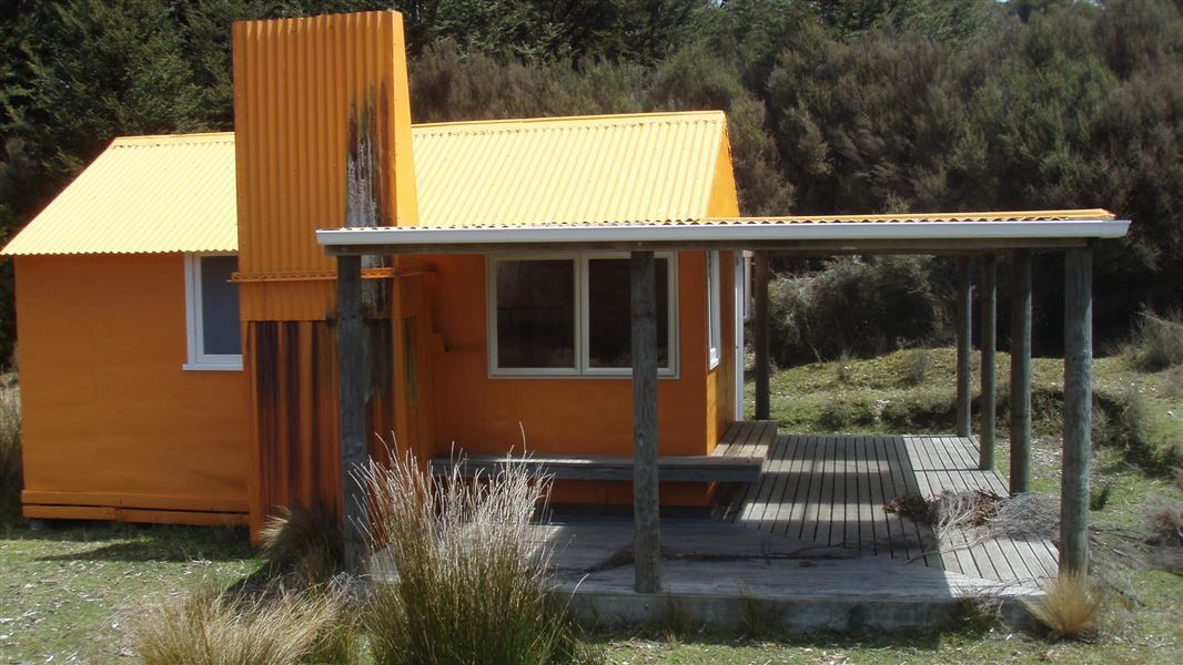
Located in the north eastern Kaweka Forest Park, Middle Hill Hut is situated in a flat, sheltered site where the open manuka/kanuka scrublands meet red beech forest.
Built in 1963 this hut was upgraded in 2003 with a large north-facing covered veranda. Middle Hill Hut is one of the few ex NZFS huts that still retains an open fireplace. The hut is sited in a open sunny clearing at 980 metres and experiences a wide range of climatic conditions which can include brief snowfalls during cold southerly weather and heavy winter frosts.
Fees
- Adult (18+ years): $10 per night
- Youth (5–17 years): $5 per night
- Child/Infant (0–4 years): free
Bookings aren't required. But before you go, buy 1 Standard Hut Ticket (blue for adults, yellow for youth) for each night's stay. Put this in the honesty box at the hut. Or buy a Backcountry Hut Pass that gives unlimited use at most Standard and Serviced huts for a 12 month period.
About hut tickets and passes | Retailers that sell hut tickets and passes
Walking
Makahu Road (2.5 – 3 hr)
From Makahu Road, a marked track climbs south west for 2 hours and then follows an undulating route across flat scrubland terraces for a further 30 – 45 minutes (5 km).
Kaweka Road – Makahu Saddle Carpark (3 hr)
From Makahu Saddle carpark a marked tracked passes Kaweka Flats Bivouac (1 hour) to reach Middle Hill Hut (5.7 km).
Tramping
Middle Hill Hut is ideally located for a day or weekend tramp. Trampers often make a semi-circular trip from Makahu Saddle via Middle Hill and out to Makahu Road as an “over-nighter” with suitable transportation arranged for drop-off and pick-up.
A “round” trip over Whetu (at the northern end of the main range) and down past Makino Hut or Te Puia Lodge is also a popular trip – this trip offers extensive views from the main range tops.
NZMS Map 260 series U20 and the Kaweka Recreational Map 274/12 can be purchased from:
Getting to Makahu Road
Makahu Road is 75 km north-west of Napier. From Napier follow Puketitiri Road for 40 km before turning right into Pakaututu Road. Makahu Road is 9 km on the left.
At the very end of the road, 500 metres from the Mangatutu Hot Springs and camping area, is "The Gums" parking area and shelter. The tracks to Te Puia Lodge and Mangatainoka Hot Springs begin here.
The trip involves about 1 hr of travel on unsealed gravel roads. There is a river ford on Makahu Road 7.5 km from the road end – heavy rain and snow melt can affect the water level.
Makahu Road is steep and narrow in places. It may be slippery when wet. Take extra caution driving this road.
The road is not suitable for caravans or campervans.
Check with Hasting's District Council for road closures.
Kaweka Forest Park access conditions
We recommend 4WD vehicles to reduce wear on the road and safe travel.
- Lotkow Road: The river crossings are regularly changing, check before crossing.
- Lakes carpark is accessible via Kuripapango road. The previous access Castle Rock road is now closed due to ongoing forestry operations.
- Lawrence Carpark access road: The last 600 m of the road is steep and not recommended for 2WD vehicles - a parking space is available before the descent. The Lawrence swing bridge has been removed.
- Mackintosh car park is currently closed due to ongoing forestry operations. A new parking location can be located at a skid site near the closed gate (end of Kuripapango Road), this will add on 500 m walking to reach the start of the track.
- Whittle Road: Be aware of trucks using the quarry. Give them right of way where possible.
Tracks to this hut
-
Duration: 2-3 hrs Difficulty: Advanced
Location
NZTopo50 map sheet: BJ37
Grid/NZTM2000 coordinates: E1895791, N5652401
DOC Customer Service Centre
| Phone: | 0800 275 362 |
| Email: | napier@doc.govt.nz |
| Address: | Ahuriri / Napier Office |