Harkness Hut is located 10 minutes walk up a side tributary of the Ngaawapurua (Harkness) Stream.
- Wood burning stove
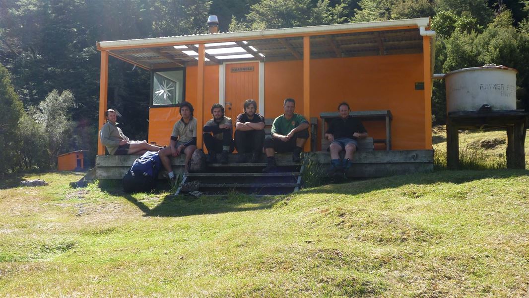
- Rainwater supply from a tank
- Meat safe
- Long drop style toilet
Built in 1961 this hut’s original standard design was upgraded in the early 1990’s, including the provision of a covered veranda overlooking the stream valley below. The hut is located 1000 metres above sea level, and is 10 minutes walk from the lower end of the Tussock Valley. The mountain beech forest rises away to the north from the hut clearing to reach Bare Top at 1386 metres. The hut can experience a wide range of climatic conditions which can include brief snowfalls during cold southerly weather and is sheltered from westerly winds.
Fees
- Adult (18+ years): $10 per night
- Youth (5–17 years): $5 per night
- Child/Infant (0–4 years): free
Bookings aren't required. But before you go, buy 1 Standard Hut Ticket (blue for adults, yellow for youth) for each night's stay. Put this in the honesty box at the hut. Or buy a Backcountry Hut Pass that gives unlimited use at most Standard and Serviced huts for a 12 month period.
About hut tickets and passes | Retailers that sell hut tickets and passes
Helicopter
There is a helipad located 45 metres immediately in front of the hut. Flight availability and costs can be obtained from helicopter concessionaires in the central North Island.
Walking
Harkness Hut can be reached by either:
Makahu Saddle Carpark - Kaweka Road (16 hr)
Tramping times from Makahu Saddle are between 6.5 – 8 hours to Tira Lodge and then up to a further 8 hours to Harkness Hut. The nearest hut from the Makahu Saddle road end is Makahu Saddle Hut (5 minutes walk from Makahu Saddle carpark). The route from Makahu Saddle climbs over the main Kaweka Range (1700 metres) via a poled track traversing the open Kaweka tops for at least one and a half hours tramping. The track passes a side track to Ballard Hut on the way. Some caution may be required during adverse weather conditions on the exposed open tops.
Boyd's Hut (6 hr)
From Boyd's Hut in the Kaimanawa Forest Park walk south past the Boyd's Airstrip to cross the Ngaruroro River. The track then climbs a long leading ridge before dropping into the top of the Tussock valley to reach Tussock Hut (3 hours). From Tussock Hut, formed tracks lead south to Harkness Hut (up to 3 hours travel).
Makino Road end (up to 14 hr)
Travel via Makino Hut dropping down into the Makino River. After travelling for a short distance upstream cross the river by a 3-wire bridge and ascend up to Mangaturutu Hut. From Mangaturutu Hut travel along the tops passing Te Puke Hut before descending down to Harkness Hut.
Tramping
Harkness Hut is well situated for brief or overnight stops when heading to further points throughout the park. It is also suitable to use as a through trip from the Kaimanawa Forest Park to Makahu Saddle carpark or Te Puia Lodge/”Gums” carpark (the west or east crossing of the park).
Tussock Hut located near the top of Tussock Valley, is a further 2 – 3 hours walk from Harkness Hut.
Kaweka Forest Park access conditions
We recommend 4WD vehicles to reduce wear on the road and safe travel.
- Lotkow Road: The river crossings are regularly changing, check before crossing.
- Lakes carpark is accessible via Kuripapango road. The previous access Castle Rock road is now closed due to ongoing forestry operations.
- Lawrence Carpark access road: The last 600 m of the road is steep and not recommended for 2WD vehicles - a parking space is available before the descent. The Lawrence swing bridge has been removed.
- Mackintosh car park is currently closed due to ongoing forestry operations. A new parking location can be located at a skid site near the closed gate (end of Kuripapango Road), this will add on 500 m walking to reach the start of the track.
- Whittle Road: Be aware of trucks using the quarry. Give them right of way where possible.
Location
NZTopo50 map sheet: BJ37
Grid/NZTM2000 coordinates: E1879742, N5656531
DOC Customer Service Centre
| Phone: | 0800 275 362 |
| Email: | napier@doc.govt.nz |
| Address: | Ahuriri / Napier Office |