Image gallery
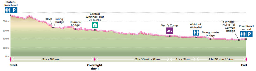
Whirinaki track elevation profile – view larger in Whirinaki walks brochure
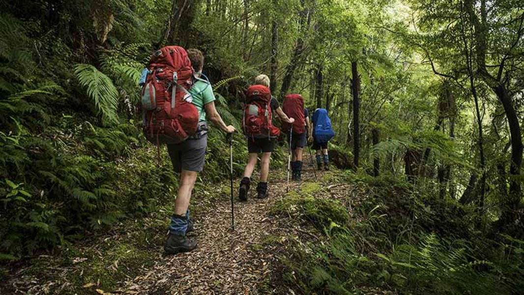
The Whirinaki Track is the premier Whirinaki experience. Following the Whirinaki River, walkers will move from beech forest to lowland podocarp forests with an overnight in Central Whirinaki Hut. As the highest standard tramping track in the park, it is relatively easy and suitable for people of low to moderate fitness levels. There are five toilets along the track.
Day 1: Plateau Rd to Central Whirinaki Hut
Time: 3 hr
Distance: 9.6 km
Begin your walk at the Plateau Road end. After 1 hour of walking, cross the Caves swing bridge. Keep an eye out for the massive cave that gives this area its name. After the swing bridge carry on with the river on the left till you reach the next major bridge named Taumutu. From the Taumutu bridge carry on till you reach Central Whirinaki Hut. This is the largest hut in the whole park and is an ideal place for an overnight stay. Relax, cook supper, and keep an eye out for whio/blue duck in the river near the hut. New Zealand forests come alive at dusk, look for pekapeka/long tailed bats flying around the hut.
Note: There is a soak hole 30 minutes south of the Central Whirinaki Hut. There is plenty room to pass however be cautious when approaching the soak hole. It is located at grid reference (E1917848 N5701039) /lat38.7821248 log176.6589134.
Day 2: Central Whirinaki Hut to River Rd
Time: 5 hr
Distance: 16 km
From Central Whirinaki Hut continue on the Whirinaki Track north to Vern’s Camp. Vern’s Camp has a shelter, toilet and is about 2 hr 30 min or 8 km from Central, so it makes a great lunch stop. After lunch carry on down the river for another hour (3 km) to the Whirinaki Waterfall. The 200 m detour to the falls is well worth the time. Across the bridge about 100 m further on, you’ll find another composting toilet and picnic tables. After visiting the falls, double back and follow the track with the river on your left side. Cross the Mangamate bridge and follow the track along the river. After about 1 hour, cross the bridge over the beautiful Te Whaiti-Nui-a-Toi Canyon. From the canyon it is only a short walk further to the River Rd carpark. Keep an ear out for Kaka/native parrot in the canopy above.
The Track is 90 km south of Rotorua.
Northern entrance – River Road carpark
- Turn off SH5 onto SH38 near Maunga Kākaramea.
- At Te Whaiti, turn into Minginui Road, then into Old Te Whaiti Road (gravel) at Minginui Village.
- Take first left into River Road and follow the signs. It's around 10 min to River Road carpark.
Southern entrance – Plateau carpark
- From Minginui Village turn into Old Te Whaiti Road (gravel)
- Take the second left into Main South road and follow the road signs for 43 km to Plateau carpark.
These roads are well signposted through to Plateau, Matakuhia, and Pukahunui carparks in the southern end of the Whirinaki Te Pua-a-Tāne Conservation Park.
Be cautious as heavy vehicles are often working in the area.
Location
NZTopo50 map sheet: BG38 (Wairapukao).
Track condition
This site may be damaged with slips, flooding or fallen trees from severe weather. Be prepared to turn back if needed.
Stay safe in the outdoors
- Choose the right trip for you. Learn about the route and make sure you have the skills for it.
- Understand the weather. Check weather forecasts.
- Pack warm clothes and extra food. Check gear lists.
- Share your plans and take ways to get help. Leave your intentions with a trusted contact and take a distress beacon.
- Take care of yourself and each other.
DOC Customer Service Centre
| Phone: | 0800 275 362 |
| Email: | easternbop@doc.govt.nz |
| Address: | Whakatāne Office |