This track is part of the Mōtū Trails and Ngā Haerenga New Zealand Cycle Trails.
20.7 km one way
Image gallery
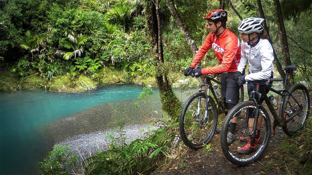
Pakihi Track is an advanced (grade 4) mountain biking adventure
There are regular rockfalls and many steep drops beside the narrow track. Do not ride this track during/soom after a storm, as falling rocks, landslides and falling trees are more common at these times.
Only ride this track if you have expert skills and experience. Mōtū Road Trail is a good alternative for intermediate mountain bikers.
The cycling direction is one-way only, starting from Motu Road. For walking or running, you can go both ways, with most doing an out-and-back trip.
Mōtū Road to Pakihi Hut (10 km)
For cyclists, the start of the Pakihi Track is from the Mōtū Road, at close to 600 m altitude. There is a small shelter and a car-parking area. The top half of the track is a steady descent, dropping over 400 m to the Pakihi Hut.
From the Mōtū Road to the hut, you cross 12 wooden bridges. It is thickly forested with trees including tawa, tōtara, rimu and rewarewa, however there are regular glimpses of far ridges. About 5 km in there are several 1.5 m wide cuttings across ridgetops. It’s impressive to think that these would have been dug by hand, over a century ago.
There are two side-tracks down to the Pakihi Hut and the stream. They’re close together and clearly signed.
Pakihi Hut to Pakihi road end (9 km)
Beyond the Pakihi Hut, the next few kilometres are the most technical for riding, and the most liable to rock falls. Take care and follow all signs.
Around 1 km after the hut you reach the Pakihi stream suspension bridge, a spectacular 32-m structure that spans a pretty gorge. On both banks, look for the remains of the abutments of the original bridge, built 1913/14 and wrecked in a massive storm in 1918.
The lower half of the track is stunning, following the Pakihi stream all the way. You may see wild trout and birds including New Zealand falcon/kārearea, North Island robin, New Zealand woodpigeon/kererū and North Island weka. There are numerous small waterways, many falling in waterfalls.
At the end of the track, there is a shelter, car park and toilet. Over the stream, Weka Wilds offers accommodation. Not far away in the Te Waiti Valley, there’s the Boulders Campsite. If you’re arranging to be picked up, it’s 23 km and a 30-minute drive from here to Ōpōtiki.
Hunters, walkers and trail runners often start from the Pakihi road end, going up and back. A popular walk is from the Pakihi road to the Mōtū Road junction, then turn around and head to Pakihi Hut for the night. This gives you a day of 30 km, with a 10 km walk out on the second day.
Cycling is one-way from Mōtū Road to Pakihi Road.
To drop cyclists off to ride the Pakihi Track: From Opotiki it’s most common to drive up the Waioeka Gorge SH2 and turn off at Matawai. Drive to the top of the hill above Mōtū, almost 800 m altitude. This is the shuttle drop-off point. From here, it’s a 9 km ride down the Mōtū Road to the top of the Pakihi Track.
Make sure you have the skills to ride Pakihi Track
Pakihi Track is an advanced (grade 4) mountain bike ride in difficult terrain. It suits riders with good off-road riding skills and considerable riding experience.
The track is narrow in places, with near-vertical drop-offs to the side. There are also obstacles like fallen trees. You need to have the skills to manage accurate line choice and control braking on loose surfaces.
Respect the track, go slow, ride with extreme caution. Most riders will need to walk some bits.
If you aren’t sure you have the experience to ride it safely, then walking is a good alternative or considering Mōtū Road Trail instead.
What to expect on the track
There are regular landslides, rockfalls and tree falls on this track. There are also steep drops beside the track in places. You will encounter:
- during rain: landslides (small and large), falling rocks and sections of the track slipping
- during substantial rain: the lower section of the track is susceptible to flash flooding
- during rain or wind: trees falling over the track
- during hot/dry weather: piles of gravel on the track.
Because of this, we strongly recommend not attempting this track during/after storms. It is best to ride/walk it during fine weather.
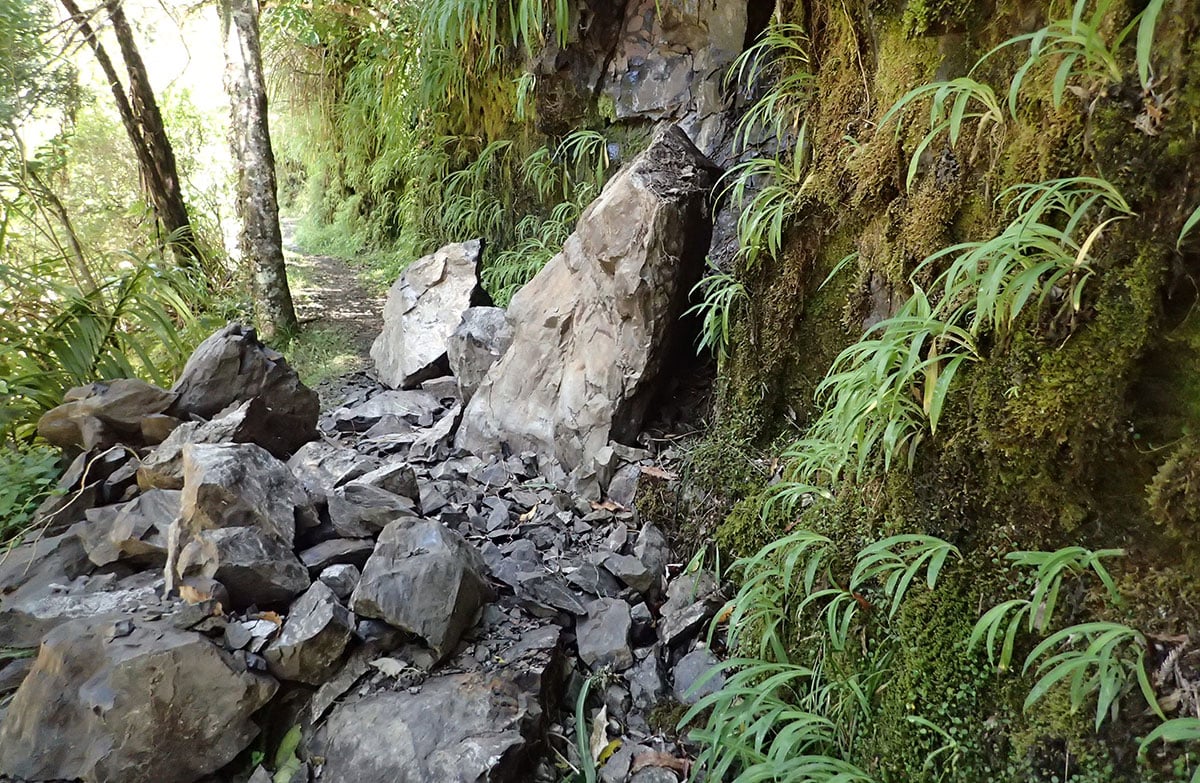
Fallen rocks on Pakihi Track
Image: Motu Trails Charitable Trust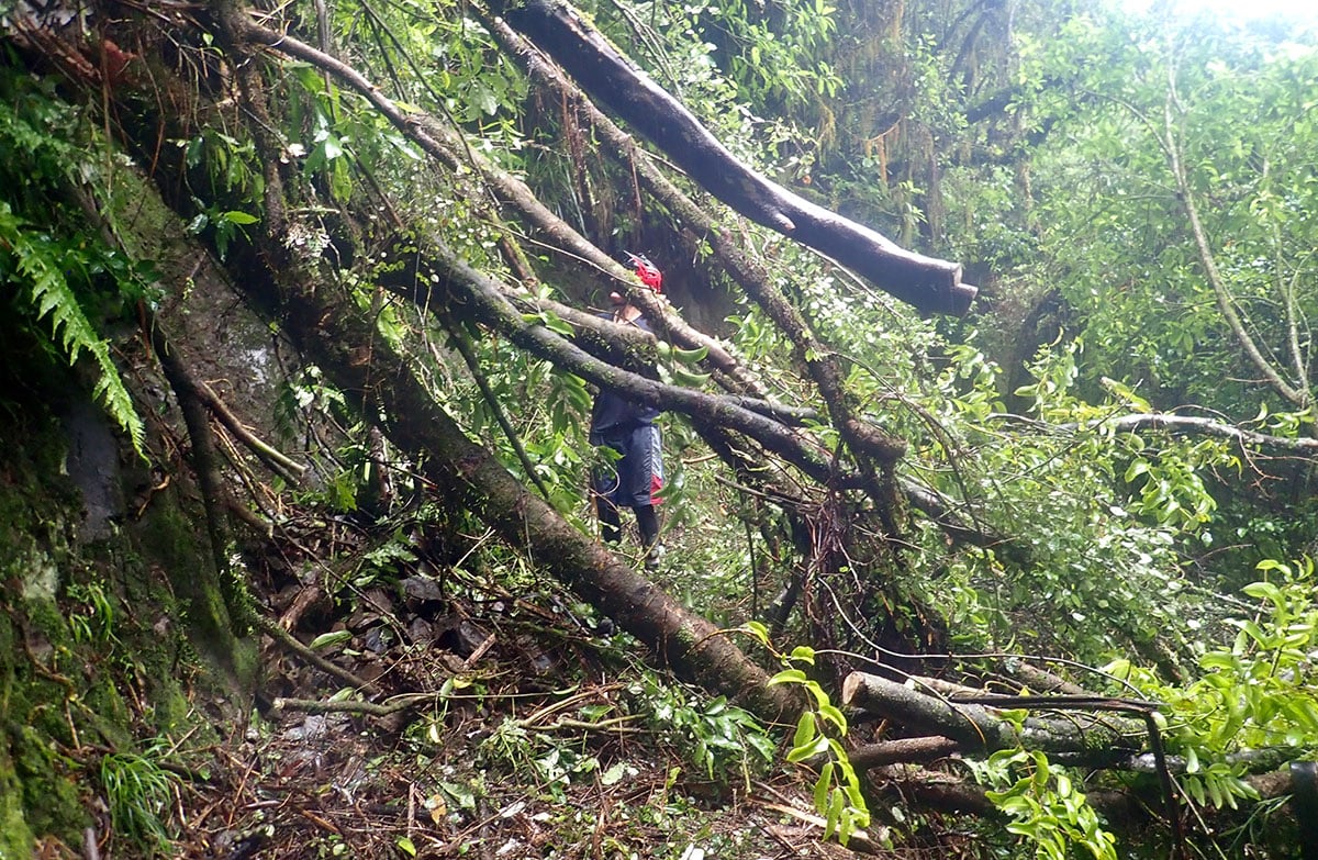
Fallen trees on Pakihi Track
Image: Motu Trails Charitable Trust
How to plan and prepare
Follow all safety signs, these show hazards and recommended walk zones. There are also often new slips, fallen rocks and fallen trees, which won't have signs.
Before you go:
- check the Motu Trails website for information about the current track conditions
- you can also contact jim@motutrails.co.nz for track updates.
Be prepared for your trip with warm clothes, a waterproof raincoat, a repair kit (for riders) and a distress beacon. There is no mobile phone coverage on the track.
Learn more about backcountry mountain biking (including suggested packing lists) on the Mountain Safety Council website. Find tramping packing lists on the DOC website.
Stay safe in the outdoors
- Choose the right trip for you. Learn about the route and make sure you have the skills for it.
- Understand the weather. Check weather forecasts.
- Pack warm clothes and extra food. Check gear lists.
- Share your plans and take ways to get help. Leave your intentions with a trusted contact and take a distress beacon.
- Take care of yourself and each other.
DOC Customer Service Centre
| Phone: | 0800 275 362 |
| Email: | easternbop@doc.govt.nz |
| Address: | Ōpōtiki Office |