This is a high protection area (HPA). Make sure you know what you can and can’t do in this area.
New marine protection
19 new marine protected areas are now in place in the Hauraki Gulf/Tīkapa Moana. These areas will contribute to a healthier Gulf for future generations.
Find boundaries and maps on this website and the marine mate app, ask your electronic chart provider or check signs at water entry points.
Motukawanui Island off the coast of Northland is free from possums, mustelids and cats, and home to a flourishing population of native birds.
This HPA extends from the mainland off the Western Coromandel Peninsula and surrounds Motukahaua/Happy Jack Island and the small islands of Motumakareta, Motuwhakakewa and up to Motupotaka/Black Rocks.
It is 11 km north of Coromandel Harbour, and 6.5 km southwest of Colville Bay.
The Motukawao Islands are reached by boat, with many boaties setting out from Papa Aroha, Waitete Bay, or Amodeo Bay.
Motukawanui Island Scenic Reserve
View a map and co-ordinates of Whakahau/Slipper Island High Protection Area.
This is a High Protection Area.
Make sure you know Hauraki Gulf protection area rules and how you can help preserve this precious ecosystem.
Report illegal or suspicious activity
Don't take, disturb, kill or damage anything within the protection areas. It is illegal. If you see people taking anything from the reserve, report it as soon as possible.
Call 0800 4 POACHER (0800 476 224) or 0800 DOCHOT (0800 362 468).
It is an offence to pollute, litter, discharge fire arms and erect structures.
Report pests
Find-A-Pest lets you report potential pest species, including marine, plant, animal and fungal species.
If you come across something out of the ordinary, upload a picture to the app and a specialist will help identify it. If it's a biosecurity threat, this will be forwarded to Biosecurity New Zealand. If possible, take photos and record the location and name of the vessel.
Or call the Ministry for Primary Industries' Pest and Diseases hotline on 0800 80 99 66.
Prevent pests from spreading
Minimise the spread of pests on land and in water by thoroughly checking and cleaning your boat and gear. Keep your favourite spots pest-free for future generations by following these guidelines:
- clean your hull out of the water before you leave, including the propeller and anchor - see guidelines for hull cleaning
- clean all recreational and boating gear
- if leaving Auckland, check the marine pests website for biodiversity rules for other regions.
Check the marine pests website for more marine biosecurity information.
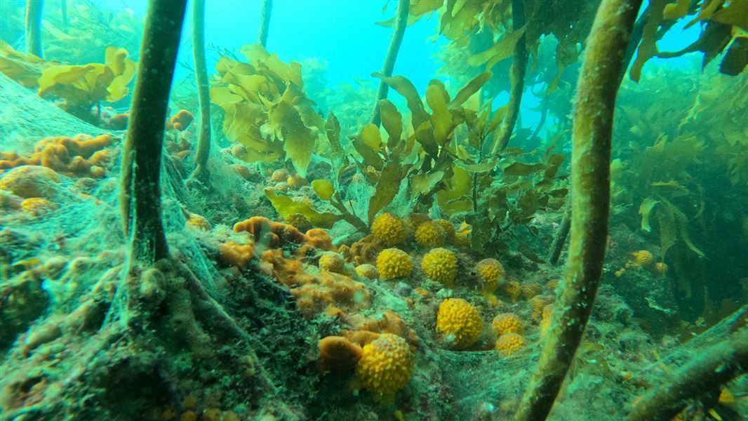
You may see seaweed forests and large populations of starfish, sea cucumbers and kina. The presence of small scallops/tīpa and flounder/karekau indicate that these bays can provide nursery habitat for some species.
You’ll also see:
- snapper/tāmure
- Jack mackerel/hautere
- red gurnard/pūwhaiau
- kahawai
- barracouta/manga.
The waters around the Motukawao were once home to undersea fields of kūtai/mussels. These bivalve molluscs were gone by the 1960s following widespread dredging. This resulted in reduced nursery habitats and nutrients. Dredging also impacted the once abundant scallop/tīpa beds.
The Motukawao group is made up of eight islands and islets. It is hoped that marine protection around these islands will improve the mauri/health of the waters, including the dog cockle beds (filter feeding molluscs) found between the islands and Coromandel Peninsula.
Motukaramarama/Bush Island has been declared an Important Bird Area by BirdLife International. This is due to the Australasian gannet/tākapu nesting site where an estimated 3500 pairs come to breed and raise their young.
The Motukawao Islands are classed as an area of Outstanding Natural Character in the Waikato Regional Coastal Plan.
Ngā Motu Aroha Trust is a local organisation actively involved in:
- habitat restoration
- invasive species control
- research and monitoring
- community engagement.
The Hauraki Gulf Marine Park/Tīkapa Moana/Te Moananui-ā-Toi has a rich history of human settlement. It includes the earliest places settled by Māori.
The area has supported the physical and spiritual wellbeing of mana whenua for centuries. Mana whenua use tikanga/customs that care for and protect the environment when collecting kaimoana/seafood. Mana whenua is the iwi or hapū that has customary authority in an area.
Volcanic in origin, the Motukawao Islands are protected by a taniwha called Ureia. A guardian to the Ngāti Hako iwi, Ureia is said to have accompanied his people across the Pacific and was seen as a symbol of the region’s abundance and mana.
Protection areas
These protection areas began in 2025. They were initiated from the Government response to the Sea Change – Tai Timu Tai Pari Hauraki Gulf Marine Spatial Plan. Sea Change was developed collaboratively by tangata whenua, environmental groups, and the fishing, aquaculture and agriculture sectors of the Hauraki Gulf between 2013 to 2017.
Help high protection areas
- No recreational or commercial fishing.
- No dumping or discharge of waste, sewage or litter.
- Take no more than a handful of shell, sand or driftwood.
- Anchoring is allowed.
- Certain Māori customary practices are allowed.
Some protection areas have exceptions to these rules.
DOC Customer Service Centre
| Phone: | 0800 275 362 |
| Email: | info@doc.govt.nz |
If you see any illegal or suspicious activity, contact the DOC emergency hotline 0800 DOC HOT (0800 362 468).